RTK GNSS Guides

Educational RTK and GNSS receiver guides for surveying, mapping, construction and field positioning decisions.

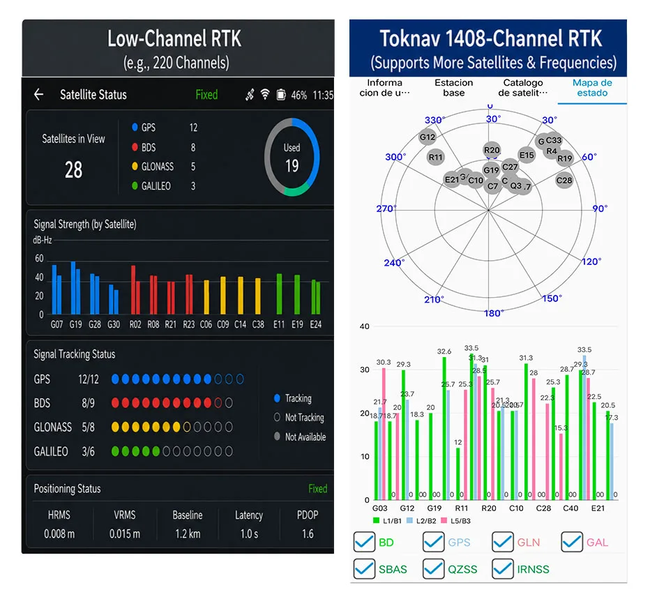
RTK channel count comparison for 1400 channels GNSS and SOC RTK chip powered receivers

Benefits of 1408 Channels: Superior RTK Performance for Modern Multi-Constellation GNSS

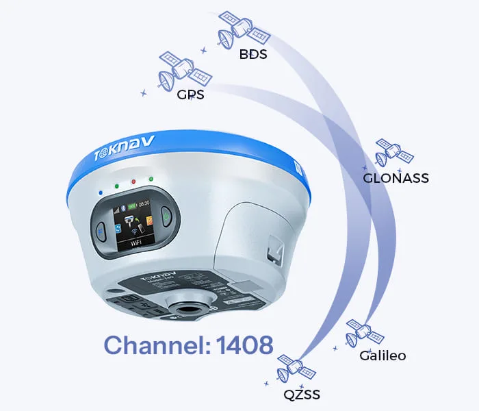
Home Benefits of 1408 Channels: Superior RTK Performance for Modern Multi-Constellation GNSS 2026-06-11 Benefits of Toknav 1408 Channels Benefits of 1408 Channels: Why Toknav’s Full RTK Lineup Leads in Multi-Constellation GNSS Positioning 1. Basic Knowledge of RTK Channel Count in GNSS Receivers 1.1 What Is an RTK Channel and Its Core Function Each RTK channel acts as an independent signal link to capture, demodulate and process satellite signals. A standard GNSS satellite transmits multiple frequency signals, and every signal requires a dedicated channel. The total RTK channel count directly decides how many satellite signals a receiver can track simultaneously in real time. RTK channel count comparison for 1400 channels GNSS and SOC RTK chip powered receivers 1.2 Drawbacks of Low-Channel Traditional RTK Devices Most old-generation RTK units only carry 100 to 600 channels. They can merely track a small number of satellites from limited constellations. In blocked areas like urban canyons or dense forests, they fail to collect enough signals, leading to slow search and frequent RTK fix loss on job sites. 1.3 How Channel Count Links to Multi-Constellation GNSS Operation Modern GNSS systems combine GPS, BeiDou, Galileo, GLONASS, QZSS and SBAS. Hundreds of satellites and diverse frequency signals operate in the air. Low-channel RTK cannot fully utilize these resources, becoming a bottleneck for high-efficiency modern positioning tasks. 2. Why 1400+ Channels Are Indispensable for Professional GNSS RTKH3: 2.1 Multi-Constellation Expansion Drives Demand for High Channel Capacity Global GNSS constellations keep expanding with new satellites and upgraded frequency signals launched each year. This clearly explains why 1400 channels GNSS has evolved from an advanced feature to a standard requirement for professional survey and positioning equipment worldwide. 2.2 1408 Channels: Full Coverage of All Mainstream GNSS Signals Toknav’s 1408 channels support full tracking of all constellations and multi-frequency signals. Unlike mid-range 800–1200 channel RTK, it never abandons weak yet valuable signals. It maximizes satellite resources to lay a foundation for stable positioning in complex scenarios. 2.3 Strong Anti-Interference and Adaptability of 1408-Channel Design Signal shielding and multipath interference are common in construction and mountainous regions. 1408 channels capture scattered satellite signals that low-channel devices miss. It optimizes satellite geometric distribution to reduce positioning errors and enhance overall reliability. 2.4 Long-Term Value: Future-Proof for Upcoming GNSS Upgradese Can Do It Satellite signal systems will continue to iterate in the next decade. A 1408-channel RTK can adapt to new satellite signals without hardware replacement. It helps users avoid repeated equipment updates and cuts long-term operating costs for engineering teams. Get 1408-Channel RTK Technical Datasheet & Quotation 3. Toknav’s SOC RTK Chip: The Core Power Supporting 1408 Full Channels 3.1 Definition and Advantages of Toknav’s Integrated SOC RTK Chip Toknav equips all RTK products with a self-developed high-performance SOC RTK chip. This system-on-chip integrates RF front-end, baseband, navigation engine and processor into one unit, replacing bulky discrete chip groups used in traditional RTK receivers. 3.2 How SOC RTK Chip Solves Multi-Channel Data Congestion Discrete chips often suffer data delay and congestion when running hundreds of channels. Toknav’s SOC RTK chip adopts optimized circuit architecture and algorithms. It distributes signal processing tasks evenly across 1408 channels to maintain ultra-low latency operation. 3.3 Power Efficiency of SOC RTK Chip for Portable RTK Devices Handheld RTK like T5 and T5Lite requires long outdoor working hours. The low-power design of Toknav’s SOC RTK chip minimizes energy consumption during full-channel operation. Users get extended battery life without sacrificing 1408-channel performance. 3.4 High Stability of SOC RTK Chip for Long-Hour Base Station Use For tBase and NET660 series base station RTK that run 24/7, the SOC RTK chip delivers stable continuous operation. It supports long-term multi-channel signal output to rovers, ensuring consistent signal transmission for large-scale CORS networks. SOC RTK chip core component supporting 1400 channels GNSS and high RTK channel count 4. Faster Satellite Acquisition and RTK Fix: The Most Obvious Benefit of 1408 Channels 4.1 Accelerated Full Satellite Search Speed Satellite acquisition is the first step of all RTK workflows. Toknav’s 1408 channels scan signals from all constellations in parallel, instead of group-by-group scanning. Field tests prove it completes full satellite search far faster than conventional low-channel RTK receivers. 4.2 Shortened RTK Fixed Solution Convergence Time RTK fix refers to centimeter-level high-precision positioning. 1408 channels collect massive valid satellite data for positioning algorithms. Rich signal samples speed up data calculation, greatly shortening the time to obtain a stable RTK fixed solution. 4.3 Rapid Reacquisition After Temporary Signal Blockage Field environments often have sudden signal occlusion from buildings or trees. Low-channel RTK needs dozens of seconds to re-search satellites. Toknav’s 1408 channels keep connecting with backup satellites and regain RTK fix within seconds to avoid work interruption. 4.4 Performance Comparison: 1408 Channels vs Ordinary Low-Channel RTK Standard 200–500 channel RTK spends 60 to 90 seconds to finish search and fix. Toknav 1408-channel RTK only needs 20 to 35 seconds for the same process. This efficiency gap directly raises daily output for surveying and mapping teams. Field test of 1400 channels GNSS RTK with great RTK channel count and SOC RTK chip 5. Toknav Entire RTK Product Line: Every Model Equipped with 1408 GNSS Channels 5.1 Economical & Handheld Portable RTK Series All lightweight handheld RTK models adopt 1408 channels, including budget-friendly T5Lite, portable T5 and engineering-standard T10Pro. They deliver fast search and fix for land planning, rural survey and basic construction measurement tasks. 5.2 High-End Laser, AR and Photogrammetry RTK Series Mid-to-high-end models T30, T40, T50 and their Pro versions integrate laser ranging, dual cameras and AR stakeout functions. Even with extra modules, they retain complete 1408 channels, keeping core positioning speed unchanged. 5.3 Professional Base Station and CORS Dedicated RTK The professional tBase base station RTK and NET660 series for CORS system construction fully support 1408 channels. For fixed base stations, abundant channels ensure stable signal coverage for multiple rovers in large engineering projects. 5.4 Special RTK for Drones, Unmanned Vehicles and Navigation NET660i-H (positioning & orientation) and NET660i-1U (unmanned vehicles) also carry 1408 channels. In drone

Benefits of 1408 Channels: Superior RTK Performance for Modern Multi-Constellation GNSS Read More »

Satellite-Based PPP Surveying for Remote Areas

Home Satellite-Based PPP Surveying for Remote Areas 2026-05-28 Executive Summary Working in the backcountry with no cell service or survey marks nearby? Precise Point Positioning (PPP) is your solution. Think of it as high-accuracy GPS that doesn’t need a local base station. Instead, your receiver gets correction data straight from satellites or pre-downloaded files. Modern multi-band receivers can use PPP to achieve centimeter-level accuracy. The catch? It takes a few minutes to “warm up.” This guide will walk you through setting up PPP, compare it to other methods, and share tips for successful remote surveys. Understanding Satellite Corrections (PPP) Ever wondered how to get precise locations without a base station? PPP is the clever answer. Unlike traditional RTK that needs a nearby reference receiver, PPP uses precise clock and orbit data from a global network. Your receiver gets this data via a satellite signal or a file you downloaded earlier. It’s perfect for places with no infrastructure. After a short initialization, you can expect 1-5 cm horizontal accuracy. You trade a slightly longer wait at the start for the freedom to work absolutely anywhere. Diagram comparing PPP surveying vs traditional RTK for high-accuracy mapping in remote areas Equipment and Configuration for PPP Surveying Getting PPP right starts with the right gear. Here’s what you’ll need: A PPP-capable GNSS Receiver: Models like the Toknav T5 or T50Pro. They must be multi-frequency to use PPP. A Good Antenna: A quality geodetic antenna minimizes signal reflection errors. Reliable Power: Long-life batteries are a must for all-day remote work. A Solid Tripod: Keeps the antenna perfectly still during the critical startup phase. A Data Collector: A rugged controller or Android device to run your survey app. Before heading out, configure your receiver: update its firmware, set your coordinate system, and input the antenna height. Then, select the ‘PPP’ or ‘RTX’ mode in the settings. If you won’t have a satellite link, remember to download the correction files for your survey dates beforehand. Comparison: PPP vs. “No-Base” RTK Method How It Connects Typical Accuracy Startup Time The Good The Not-So-Good PPP (Satellite) Satellite signal or offline files. ~1-5 cm horizontal, ~5-10 cm vertical. Several minutes. No local base needed! Works globally, even with zero cell service. Slower to start. Needs a clear view of the sky. May require a subscription. RTK (No Local Base) Needs internet (NTRIP) or long-range radio to a distant base. ~1-2 cm horizontal, ~2-4 cm vertical. Seconds to a minute. Extremely fast and accurate when the link works. A proven method. Totally dependent on a stable connection to a base or network. Fails outside coverage. Accuracy, Convergence, and What to Watch Out For PPP is impressively accurate, often hitting 2-5 cm horizontally after it initializes. That’s similar to what you expect from RTK. The key difference is convergence time—that initial wait. It usually takes a few minutes, but sometimes up to 15-20 minutes in challenging spots. The receiver needs this time to lock onto the satellite corrections and resolve ambiguities. A few things can affect your success: Keep it Still: During initialization, don’t move the antenna. Clear Sky View: Avoid trees, cliffs, or buildings that block satellites. Check Settings: A wrong antenna height entry will give wrong coordinates. Use Good Gear: A quality multi-band receiver and antenna make a huge difference. Log Raw Data: Always record raw data (RINEX format) as a backup. This lets you reprocess it later if needed. Troubleshooting Tips for Remote PPP Surveys Ran into a problem? Don’t worry, here are some fixes: Won’t Start?: Confirm you selected the right correction source and that your receiver’s service subscription is active. Poor Accuracy?: Check for signal obstructions. Move to a more open spot. Wrong Coordinates?: Re-enter your antenna height and datum (like WGS84). General Tip: Patience is key. If it’s taking a while, just let the receiver keep working. It will usually get there. By following these steps, you can confidently survey in the most remote locations. PPP trades a bit of initial patience for ultimate freedom. So go ahead, map that uncharted territory! Want to explore more about surveying? Click here: Blog – TOKNAV.  Have field experiences to share? Contact us at info@toknav.cn.

Satellite-Based PPP Surveying for Remote Areas Read More »

Smallest RTK Receiver for Survey: Top Toknav Picks for 2026

Home Smallest RTK Receiver for Survey: Top Toknav Picks for 2026 2026-05-16 Pocket RTK GPS: Why Size Matters in Surveying Mini GNSS Receiver Benefits for Field Work Compact survey gear has revolutionized modern surveying. The demand for the smallest RTK receiver for survey is rising, as professionals prioritize portability without sacrificing precision. A reliable pocket RTK GPS eliminates bulk, reducing fatigue during long field days. A well-built mini GNSS receiver fits in pockets or small bags, ideal for tight sites or remote missions. Toknav leads this trend, designing ultra-compact RTK receivers that redefine convenience. For modern field teams, compact survey gear is no longer optional—it’s essential for speed and accuracy. Top Toknav Mini GNSS Receiver Models smallest RTK receiver for survey Toknav T5 T5Lite mini GNSS receiver compact survey gear Toknav T5: Flagship Pocket RTK GPS The Toknav T5 stands as a top mini GNSS receiver for surveyors. Weighing just 630g with 100.5×100.5×72mm dimensions, it’s ultra-portable. Its magnesium alloy build and IP65 rating ensure durability in harsh conditions. The 1408-channel engine supports all GNSS constellations (GPS, BDS, GLONASS, GALILEO). Built-in 4G, Bluetooth, WIFI, and a radio module add versatility. As the flagship pocket RTK GPS, the T5’s 9600mAh battery delivers 16+ hours of runtime, perfect for all-day surveys. It’s the ultimate smallest RTK receiver for survey that doesn’t compromise performance. Get a Quote Now Toknav T5Lite: Budget-Friendly Compact Survey Gear For cost-conscious professionals, the Toknav T5Lite is ideal compact survey gear. At 600g and 100.5×100.5×69mm, it’s even lighter than the T5. It shares the same 1408-channel GNSS engine and multi-constellation support. The IMU module enables 60° tilt measurement with <2cm correction accuracy. Linux OS and 32GB storage ensure smooth operation. IP65 protection and 16+ hour battery life match premium models, making it a top budget pocket RTK GPS. If you need the smallest RTK receiver for survey on a budget, the T5Lite delivers exceptional value. Toknav T50 Series: Palm-Sized High-Tech RTK smallest RTK receiver for survey Toknav T50 series pocket RTK GPS compact survey gear The Toknav T50 series elevates the smallest RTK receiver for survey standard. These palm-sized units (Φ132×83mm, 770g) pack advanced features. The T50 adds a 100m laser module and AR camera for real-time stakeout, with 2.5cm 3D laser error at 5m. T50basic offers core AR and tilt functions, while T50Pro integrates photogrammetry (2–4cm accuracy at 2–15m). All models have IP68 rating, 6500mAh batteries (16+ hours), and 20Hz high-rate positioning. This mini GNSS receiver lineup redefines what pocket RTK GPS can achieve for complex projects. Explore Full Specifications Key Features of Toknav Pocket RTK GPS Receivers Unmatched Portability for Mini GNSS Receiver Toknav prioritizes compactness across all models. The T5Lite (600g) and T5 (630g) are among the lightest professional RTK receivers. The T50 series’ palm-sized design fits easily in one hand. This portability makes them perfect for urban surveys, construction layouts, and agricultural mapping where mobility is critical. No need for heavy tripods or large cases—just grab and go. When you choose the smallest RTK receiver for survey, you gain agility without losing precision. Precision That Rivals Full-Size Survey Gear Size doesn’t compromise accuracy with Toknav compact survey gear. All models deliver RTK accuracy of ±(8mm+1ppm) horizontal and ±(15mm+1ppm) vertical. Static precision reaches ±(2.5mm+1ppm) horizontal. The 1408-channel GNSS engine tracks all major constellations, ensuring reliable positioning in challenging environments like dense forests or urban canyons. IMU tilt correction (up to 60°) maintains accuracy without leveled poles. This pocket RTK GPS lineup proves small size and high precision can coexist. costumer feedback about grass sports field marking Request a Demo Today Rugged Durability for Field Conditions Field surveying demands tough equipment, and Toknav mini GNSS receiver units deliver. T5 and T5Lite feature magnesium alloy bodies with IP65 protection, withstanding dust, rain, and 1.5m drops. T50 series upgrades to IP68, offering full water and dust resistance. Operating temperatures range from -20°C to +60°C (T5/T5Lite) and -30°C to +65°C (T50 series), adapting to extreme climates. These rugged specs ensure reliability in any environment—critical for the smallest RTK receiver for survey that works as hard as you do. Long-Lasting Battery for All-Day Surveys Downtime from dead batteries is a surveyor’s worst enemy. Toknav pocket RTK GPS receivers include high-capacity batteries. T5 and T5Lite use 9600mAh batteries for 16+ hours of typical use, with static mode supporting 24-hour data collection. T50 series uses 6500mAh batteries, also delivering 16+ hours in controller network mode. Fast charging support minimizes downtime, keeping you productive all day. Great compact survey gear keeps you in the field, not at a charger. Advanced Connectivity & Smart Features: Modern surveying requires seamless connectivity, and Toknav compact survey gear excels here. All models include 4G full network access, Bluetooth, WIFI, and integrated radio modules. The radio supports multiple protocols (TRIMTALK, SOUTH, TRANSEOT) for flexible data transmission. Linux OS (ARM Cortex-A7 1.8GHz) enables efficient computing and feature expansion. T50 series adds AR cameras, laser modules, and photogrammetry for advanced workflows. This mini GNSS receiver lineup turns every field task into a streamlined operation. Why Choose Toknav for the Smallest RTK Receiver for Survey Unbeatable Size-to-Performance Ratio Toknav dominates the mini GNSS receiver market with an unbeatable size-to-performance ratio. Competitors often sacrifice features for compactness or vice versa. Toknav’s T5, T5Lite, and T50 series balance ultra-portability with professional-grade precision, durability, and smart features. Whether you need a basic pocket RTK GPS or a high-tech palm-sized unit, Toknav has a model to match your needs. For the smallest RTK receiver for survey, no other brand matches this balance. Versatility for Diverse Survey Applications From construction and land surveying to agriculture and GIS mapping, Toknav compact survey gear adapts to diverse applications. The T5Lite suits budget-focused land surveys. The T5 excels at general construction and topographic surveys. The T50 series shines in complex projects requiring AR stakeout, laser measurement, or photogrammetry. All models support standard NMEA-0183 and RTCM 3.X protocols, ensuring compatibility with existing workflows. One mini GNSS receiver can handle nearly every job site challenge. Contact Our Team for Details Trusted Quality

Smallest RTK Receiver for Survey: Top Toknav Picks for 2026 Read More »

What Defines Industrial Grade GNSS? Rugged RTK GPS, Heavy Duty GNSS & Outdoor Survey Tools

Home What Defines Industrial Grade GNSS? Rugged RTK GPS, Heavy Duty GNSS & Outdoor Survey Tools 2026-04-25 What Makes GNSS Truly Industrial Grade? Industrial grade GNSS is not just about precision. It is built to survive harsh field conditions while delivering consistent RTK performance. For surveyors, construction teams, and geospatial professionals, rugged RTK GPS, heavy duty GNSS, and reliable outdoor survey tools must resist water, dust, drops, and extreme temperatures. Toknav designs its receivers around these three non-negotiable pillars: IP68 waterproof/dustproof, 1.5m drop resistance, and ultra-wide operating temperature. This blog explains how these features define real industrial quality. Core Standards of Industrial Grade GNSS Durability That Outlasts Harsh Environments True industrial grade GNSS must operate reliably where consumer devices fail. It needs full sealing against dust and water, physical shock resistance, and stable performance across extreme temperatures. These features are not optional—they are mandatory for heavy duty GNSS used daily in construction, mining, mapping, and precision agriculture. Precision Meets PersistenceIndustrial GNSS combines centimeter-level RTK accuracy with 24/7 resilience. Whether used as rugged RTK GPS for stakeout or static outdoor survey tools, it must maintain fixed solutions in rain, snow, heat, or vibration. Toknav receivers deliver ±(8mm + 1ppm) horizontal RTK accuracy without compromising toughness. Pillar 1 – IP68 Rating: Fully Waterproof & Dustproof Industrial Protection IP68 Explained – Zero Intrusion, Maximum Reliability IP68 is the highest standard for portable industrial electronics. It means 100% dust tight and submersible in water under defined pressure and time. For field crews, this eliminates downtime from rain, mud, splashes, or accidental immersion. Why IP68 Matters for Outdoor Survey Tools Jobsites expose gear to blowing dust, flooding, mud, and salt spray. Lower ratings like IP65 or IP67 only resist splashes or short immersion. Toknav’s IP68 rugged RTK GPS keeps working through storms and floods, protecting internal modules and extending service life. Toknav IP68 Implementation All Toknav high end models including T10Pro, T20Pro, T30 series, T40 series, T50 series, and NET660 series use IP68 rated magnesium alloy casings. They meet strict industrial sealing standards and are certified CE, FCC, KC, and NGS for global use. This makes them trusted heavy duty GNSS for survey and monitoring worldwide. Industrial Grade GNSS Rugged RTK GPS Heavy Duty Outdoor Survey Tools IP68 Pillar 2 – 1.5m Drop Resistance: Built for Rough Handling Industrial Strength Shock Protection Field work involves drops, knocks, pole falls, and transport vibration. A single drop can break consumer grade GNSS. Industrial receivers need structured shock absorption and reinforced housing. Toknav Drop-Tested Rugged RTK GPS Jobsites expose gear to blowing dust, flooding, mud, and salt spray. Lower ratings like IP65 or IP67 only resist splashes or short immersion. Toknav’s IP68 rugged RTK GPS keeps working through storms and floods, protecting internal modules and extending service life. Drop Resistance for Heavy Duty GNSS Workflows Whether climbing, hiking, or moving across rough terrain, users cannot avoid accidents. Toknav’s shock-proof design ensures outdoor survey tools stay functional even after repeated drops. This is industrial-grade confidence. Industrial Grade GNSS Rugged RTK GPS Heavy Duty Outdoor Survey Tools IP68 Pillar 3 – Ultra-Wide Temperature: Perform in Freezing & Scorching Heat Temperature Stability Defines Industrial Grade Performance Electronics struggle in extreme cold or heat. Consumer GNSS may shut down, lose signal, or suffer battery failure. Industrial heavy duty GNSS must maintain function across wide thermal ranges. Toknav Wide-Temp Specifications Most Toknav receivers operate from -20°C to +60°C. The T50 series extends this to -30°C to +65°C, and NET660i series supports -40°C to +85°C for CORS and remote monitoring. Storage temperature reaches -40°C to +85°C across flagship lines. H3: Reliability for Year-Round Outdoor Survey Tools From Arctic winters to desert summers, Toknav GNSS works uninterrupted. Thermal stability ensures consistent RTK tracking, IMU tilt survey, and data logging. This makes it ideal for rugged RTK GPS in global field applications. Industrial Grade GNSS Outdoor Survey Tools Wide Temperature Rugged RTK GPS How Toknav Merges Ruggedness & High Performance 1408 Channels & Full Constellation Tracking Toknav receivers support GPS, GLONASS, Galileo, BDS, QZSS, SBAS, and NavIC. With 1408 tracking channels, they maintain fast lock and stable RTK fix even in challenging environments. IMU Tilt Survey (60°) Integrated IMU enables tilt compensation up to 60°, so users collect accurate data without perfect leveling. This boosts efficiency for outdoor survey tools in steep or blocked areas. H4: Long Battery Life & Fast Charging Batteries support 16–48 hours of field use. Fast charging via USB PD and adaptive power management reduces downtime. Hot swappable batteries in T40 series keep crews working continuously. Integrated 4G, WiFi, Bluetooth & Radio Built-in 4G full netcom, WiFi, Bluetooth, and high-power radio (up to 5W) ensure strong data links. Radio range exceeds 16km in open areas, ideal for rugged RTK GPS base-rover setups. Applications – Where Toknav Industrial GNSS Excels Construction & Engineering Survey IP68, drop resistance, and wide temperature make Toknav perfect for layout, excavation, and machine control. Heavy duty GNSS performs reliably on busy, dusty, and wet construction sites. H3: Mining & Geological Survey Harsh mining conditions demand extreme durability. Toknav receivers resist dust, vibration, and impact while delivering high precision positioning for mapping and monitoring. H3: Deformation Monitoring & CORS Networks NET660 series with IP68 and  40°C to +85°C operation provides stable reference data. They are ideal for long term structural monitoring and CORS base station applications. Precision Agriculture & Autonomous Systems Wide temperature and rugged sealing support agricultural machinery control, unmanned vehicles, and smart farming. Rugged RTK GPS ensures consistent positioning in all weather. Utilities, Forestry & Environmental Survey From power lines to forests, field crews face unpredictable conditions. Toknav outdoor survey tools keep working in rain, snow, heat, and rough terrain. Why Choose Toknav Industrial Grade GNSS? Verified Industrial Durability IP68, 1.5m drop resistance, and wide-temperature performance are fully tested and certified. Toknav does not compromise on build quality. High Precision RTK Performance Centimeter-level accuracy, 1408 channels, and IMU tilt survey make Toknav competitive with premium brands—at better value. True Heavy Duty Design Magnesium alloy casing, reinforced

What Defines Industrial Grade GNSS? Rugged RTK GPS, Heavy Duty GNSS & Outdoor Survey Tools Read More »

Honoring the Unsung Heroes of Precision: A Tribute to Surveying and Mapping Workers on Labor Day 2026 + Toknav Official Holiday Arrangement

Home Honoring the Unsung Heroes of Precision: 2026 Labor Day tribute to surveying workers+ Toknav Official Holiday Arrangement 2026-04-25 Introduction: Why Surveying Professionals Deserve Our Deepest Respect This Labor Day If you stop to think about it, every road, every bridge, and every new urban community all starts with one essential job: professional surveying and mapping. Behind every clear coordinate and every solid engineering benchmark, there are hardworking surveying crew members working tirelessly outdoors. They face tough weather, walk long distances across rough ground, and stay on-site all year round. Simply put, they build the invisible foundation for every construction project we rely on. Labor Day isn’t just a long weekend to relax. It’s our chance to say thank you to every hardworking person who shows up, stays focused, and gets the job done well. Especially in the surveying industry, reliable field workers keep every project safe and accurate. In this warm holiday blog, we want to sincerely honor all global surveying and mapping frontline workers. We’ll also share Toknav’s official 2026 May Day holiday schedule, so all clients, partners, and survey teams can easily plan construction, orders, and technical support in advance. The Silent Dedication of Surveying and Mapping Frontline Workers: Guarding Precision with Persistence Working in all terrains, never afraid of harsh working conditions Let’s be real, office work is comfortable, but surveying work is completely different. Most surveyors spend almost all their working hours outside in the field. They climb hills, walk through muddy land, stand beside busy roads, and work on crowded construction sites every single day. No matter if it’s burning hot summer or cold windy winter, they carry survey gear, check points, collect data, and finish every measurement task on time, no excuses. Thanks to their careful repeated checks, many hidden construction risks and geological dangers are found early before problems happen. Every step they take makes construction safer, steadier, and more standard. They never chase attention or praise. They just quietly do their best to keep cities stable and projects reliable. This Labor Day, the whole Toknav team wants to send our warmest thanks and deepest respect to every frontline surveyor around the world. 2026 Labor Day tribute to surveying workers working with Toknav high-precision GNSS surveying equipment Bearing heavy responsibilities, holding precision as the core professional bottom line In surveying work, there is simply no room for mistakes. Even a tiny coordinate error can cause big rework, safety risks, and costly project losses. That’s why frontline surveyors always stay serious, patient, and focused. They double-check data, calibrate instruments many times, and record every detail carefully. Precision is not just a rule for them, it’s their daily work habit. From large highway and bridge projects to farmland surveys, city planning, and geological safety monitoring, surveyors are always the first on-site and the last to leave. With their professional skills, they lock in precise spatial data, support every construction stage, and quietly protect the safety of urban development. Truly, they are the unseen guardians behind every infrastructure project. Low-key dedication, worthy of the most sincere Labor Day praise If you work in engineering, you know it well: surveying workers are often the quiet, unsung heroes of the whole industry. No cozy offices, no air conditioning, just sun, wind, rain, and long outdoor walks every day. But think about it, without their hard work, we would have no safe roads, no standard buildings, and no complete geographic information systems at all. Labor Day is here to celebrate every ordinary person who works hard and stays dedicated. This year, we want to shine a special light on surveying frontline workers across the globe. Thank you for your patience, your strong work ethic, and your commitment to precision. Your hard work truly makes the whole industry better. How High-Quality GNSS Surveying Tools Empower Frontline Surveying Workers Efficiently We respect every laborer’s effort, and we also believe good tools should make tough field work easier. Old traditional survey tools are heavy, slow, and easy to be disturbed by bad weather or complex terrain. They make field workers more tired and waste valuable time. Luckily, modern GNSS high-precision technology has changed everything, making daily survey work faster, simpler, and much more efficient. Today’s professional GNSS survey devices offer real-time centimeter-level accuracy, stable all-weather satellite signals, and fast cloud data sharing. They work perfectly in mountains, forests, wetlands, and crowded city areas with tall buildings. Good surveying gear lowers fatigue, cuts working time, and keeps data highly accurate. Honestly, reliable GNSS tools are the best partner every field surveyor can have. Toknav: Always Empower Global Surveying Teams with Reliable GNSS Precision Solutions At Toknav, we truly understand how hard frontline surveyors work, so we always deliver reliable high-precision GNSS surveying equipment to support them. We are a friendly, professional global supplier focused entirely on high-precision GNSS positioning, Toknav GNSS RTK receiver development, and complete professional mapping positioning solution packages. For years, we have stood side by side with survey teams, engineering companies, and mapping institutions worldwide. Our goal is simple: create durable, easy-to-use, affordable GNSS equipment and provide caring, reliable technical support to lighten your field workload while optimizing every detail for real surveying scenarios. costumer feedback about grass sports field marking Every Toknav GNSS product is carefully developed and strictly tested under real harsh outdoor conditions. Our full range of RTK receivers, CORS base stations, data controllers, antennas, and survey accessories all hold CE and FCC international certifications. They feature strong anti-interference, long-lasting batteries, and steady performance, perfectly matching your all-day outdoor survey routines. Our popular T30, T40, and T50 RTK series come with practical smart functions: laser ranging, AR visual stakeout, full-system satellite reception, and smart cloud data management. With horizontal accuracy up to ±8mm and vertical accuracy up to ±15mm, these devices easily meet strict standards for railways, bridges, water conservancy, and land survey projects. Also, our self-developed tBase CORS station runs non-stop to build stable local positioning networks for large-area surveys. The built-in PPP autonomous

Honoring the Unsung Heroes of Precision: A Tribute to Surveying and Mapping Workers on Labor Day 2026 + Toknav Official Holiday Arrangement Read More »

GNSS Signal Blocked? Try This IoT-Assisted Rapid Re-survey Method for Engineering Control Networks – Millimeter-Level Accuracy & Doubled Efficiency

Home GNSS Signal Blocked? Try This IoT-Assisted Rapid Re-survey Method for Engineering Control Networks – Millimeter-Level Accuracy & Doubled Efficiency 2025-04-14 Friends in surveying and engineering must have encountered the same frustrating problem – control network re-survey, especially in scenarios with severe GNSS signal obstruction (such as mountainous areas, factories, and dam surroundings), which is simply “an arduous task”! Control networks are like the “eyes” of a project. Regular re-survey is essential to ensure the reliability of subsequent construction and monitoring. However, common re-survey methods on the market either have limited application scenarios or are inefficient to the point of frustration. Today, I will share a practically proven solution – an IoT-assisted rapid re-survey method for engineering control networks, which achieves millimeter-level accuracy and doubles efficiency in actual tests! IoT-Assisted Rapid Re-survey Method for Engineering Control Networks System Architecture Perception layer: The protagonist is the “remote-controlled prism” – we have modified ordinary prisms to adjust their orientation remotely, eliminating the need for manual adjustment at control points, which is the key to improving efficiency; Network transmission layer: LoRa technology is adopted. You may not be familiar with this technology, but its advantages are obvious – long transmission distance and strong anti-interference ability. Even in complex environments such as mountainous areas and dams, it can stably transmit control signals. It is worth mentioning that all Toknav’s RTK devices have the same advantages as LoRa technology and can also achieve stable transmission in complex surveying scenarios. For more information, you can check out Learn more > Application layer: It is the control software we operate, with a simple interface. It can remotely control the prism orientation, view measurement data, and realize full-process visualization, making operation very simple. The entire re-survey process is also very simple: deploy remote-controlled prisms at each control point, the operator operates the total station at a fixed position, remotely adjusts the prism orientation through the application layer software, and the total station automatically completes angle and distance measurement. No need to travel back and forth between control points, completing the task in one step. Actual Test Verification: Accuracy Uncompromised, Efficiency Doubled! Talking the talk is not enough; walking the walk is. We conducted an experiment on an actual project (the plane control network of a hydropower station dam), comparing the re-survey effects of the “IoT-assisted method” and the “total station only” method. The results were really surprising! Accuracy: The re-survey accuracy of the two methods is completely consistent, reaching sub-millimeter level, which fully meets the re-survey requirements of engineering control networks, so there is no need to worry about accuracy degradation; Efficiency: Taking working hours as the indicator, the efficiency of the IoT-assisted method is about 107% higher than that of using only the total station – simply put, a re-survey task that used to take two days can now be completed in one day, saving half the time directly! More importantly, this method does not rely on GNSS signals. As long as there is line of sight between control points (a basic requirement for traditional total station measurement), it can work normally no matter how severe the surrounding obstruction is. Many actual engineering control networks are laid out as angle-distance networks, which are just suitable for this method, with broad application prospects. Summary & Future Outlook In summary, this IoT-assisted rapid re-survey method for engineering control networks perfectly solves the pain points of traditional methods: “low efficiency, tiring labor, and limited scenarios”: No manual trips to control points to adjust prisms, with full automation, reducing labor costs and safety risks; The accuracy is consistent with that of traditional total stations, reaching sub-millimeter level, meeting engineering needs; It does not rely on GNSS signals and can easily handle scenarios with severe obstruction, with a wider scope of application; Efficiency is increased by 107%, greatly shortening the re-survey period. Of course, this method still has a small regret – it has not been applied in complex terrain (such as high mountain canyons) or ultra-large-scale control networks. In the future, we will continue to improve, and strive to verify it in more complex scenarios, so that this method can help more friends in engineering and surveying. If your project also encounters problems of GNSS signal obstruction and low re-survey efficiency, you may wish to try this method – it has been proven useful in actual tests! If you have any related questions, you can also leave a message in the comment area to communicate~ Reference: [1] Zhou Jianguo, Gan Youhuizi, Chen Yanchong. IoT-Assisted Rapid Re-survey Method and System for Engineering Control Networks[J]. Science of Surveying and Mapping, 2026, 51(02): 33-40. DOI:10.16251/j.cnki.1009-2307.2026.02.004.

GNSS Signal Blocked? Try This IoT-Assisted Rapid Re-survey Method for Engineering Control Networks – Millimeter-Level Accuracy & Doubled Efficiency Read More »

TokNav T30 Pro RTK working in outdoor area

Qingming Field Survey: TokNav T30 Pro RTK for Accurate Outdoor Mapping

Home Qingming Field Survey: TokNav T30 Pro RTK for Accurate Outdoor Mapping 2026-04-05 April brings the Qingming Festival, which is not only one of China’s 24 solar terms but also a traditional festival similar to foreign memorial days like Russia’s Radonitsa, Mexico’s Día de los Muertos, and France’s All Souls’ Day—all dedicated to honoring the deceased. Falling when the sun reaches 15° celestial longitude, Qingming is a time of mild weather and fresh greenery, ideal for field surveying, topographic exploration, and land inspection. For surveyors, this season offers great opportunities but also challenges: uneven terrain, changing weather, and long work hours. Reliable, high-performance equipment is key, and the TokNav T30 Pro RTK emerges as the perfect companion for Qingming field survey. Why Choose the TokNav T30 Pro RTK for Your Field Surveys? TokNav T30 Pro RTK working in outdoor area The TokNav T30 Pro RTK’s core strength is its high-precision positioning. It features a built-in high-precision GNSS module with 1408 high-speed channels, supporting all major satellite systems (BDS, GPS, GLONASS, Galileo, QZSS). This comprehensive coverage ensures stable positioning even in wooded areas common during Qingming outings, where satellite signals may be partially blocked. The TokNav T30 Pro RTK delivers exceptional accuracy: in RTK mode, it achieves ±(8mm+1ppm) horizontal and ±(15mm+1ppm) vertical accuracy; static mode offers ±(2.5mm+1ppm) horizontal and ±(5mm+1ppm) vertical accuracy. This precision lets surveyors collect reliable geographic data for land mapping, construction layout, or resource investigation without repeated measurements. Its AR real-time stakeout function is particularly useful for Qingming field survey. Equipped with a professional ultra-wide-angle AR camera (1/2.8-inch sensor, 1920*1080 resolution), the device overlays survey data directly onto the real-world view. This eliminates cumbersome traditional stakeout methods, letting surveyors locate target points quickly—even in unmarked areas. TokNav T30 Pro RTK’s AR stakeout Battery life is critical for long Qingming field surveys in remote areas. The TokNav T30 Pro RTK has a 7.2V, 13800mAh battery, supporting over 48 hours of continuous operation in controller network mode—enough for two full workdays on one charge. It also supports fast USB PD charging (15V/2A, 5V/3A) with adaptive current adjustment, enabling quick recharges during breaks.Built for outdoor rigors, the TokNav T30 Pro RTK has an IP68 protection rating (dust-tight and water-resistant), ideal for Qingming’s sudden light rain or damp conditions. Its magnesium alloy casing with ABS/PC top cover ensures durability, withstanding 1.5m drops at normal temperatures. Its -20°C to +60°C operating range adapts to the season’s cool mornings and warm afternoons.Connectivity is another advantage: the TokNav T30 Pro RTK supports 4G full Netcom, Bluetooth, and Wi-Fi, ensuring stable connections in remote areas. Its 4G solution, based on Linux+ARM Cortex-A7, works with all major operators, while a 5W data transmission radio (410~470MHz) enables seamless data sharing with other survey tools. For image surveys, the TokNav T30 Pro RTK offers a high-performance IS camera (1/2.6-inch, 6mm focal length, 1920*1080 resolution) with high-precision inertial navigation. Paired with Android handheld devices, it delivers accurate image measurement—perfect for large areas or hard-to-reach spots like steep slopes. Its tilt measurement function, powered by a high-precision IMU module, supports up to 60° inclination with <2cm correction accuracy. This lets surveyors work on uneven terrain without keeping the device vertical, saving time during Qingming outdoor mapping. TokNav, a leader in high-precision positioning, designs the TokNav T30 Pro RTK for surveyors’ diverse needs. It runs on a Linux system for efficient computation and expandability, with 32GB storage for daily survey data and images. Qingming field survey needs accurate, reliable, easy-to-use equipment—and the TokNav T30 Pro RTK delivers. Its precision, long battery life, AR stakeout, and rugged design make it ideal for the season. Whether for land inspection, topographic mapping, or construction layout, it ensures efficient, accurate work even in complex environments. To boost your Qingming field survey efficiency and unlock intelligent positioning, consult TokNav GNSS. Visit the TokNav T30 Pro RTK product details page to learn more. Let the TokNav T30 Pro RTK be your trusted outdoor survey assistant this Qingming.

Qingming Field Survey: TokNav T30 Pro RTK for Accurate Outdoor Mapping Read More »

Toknav T20 Pro: Top-Tier Rugged Industrial GNSS Receiver for Extreme Job Sites

Home Toknav T20 Pro: Top-Tier Rugged Industrial GNSS Receiver for Extreme Job Sites 2026-03-16 In surveying and construction, equipment failure isn’t just an inconvenience—it’s a threat to safety, budgets, and deadlines. The Toknav T20 Pro isn’t another GNSS receiver with impressive specs on paper; it’s a field-proven workhorse engineered to outlast the harshest conditions, including a real-world high-voltage electrocution event that would destroy any standard device. This real incident was documented in our official post: https://www.facebook.com/share/r/1CjhnsNMFZ/ Small Form Factor, Big Performance Gone are bulky high-precision GNSS devices. TOKNAV’s compact ecosystem fuses miniaturization with uncompromised performance, fitting enterprise-grade positioning into handheld tools, unmanned systems and embedded devices. The flagship T50 (Φ134mm*86mm, ≤0.78Kg) delivers centimeter-level RTK accuracy, full-system satellite tracking and intelligent features. For OEMs, our GNSS OEM board eliminates size constraints, enabling precision integration in millimeter-critical designs. TOKNAV T20Pro GNSS reciever Compact GNSS Receiver Use Cases: Real-World Applications TOKNAV’s compact solutions drive efficiency in real high-stakes projects across industries: Urban Engineering: Shanghai’s municipal team used T50 for road/bridge surveying, cutting field time by 40% in tight urban spaces with IP68 ruggedness and anti-signal-blockage performance. Geological Monitoring: Sichuan’s landslide project embedded TOKNAV RTK OEM board into mini terminals, slashing size by 60% and extending battery life to 30+ days for unattended mountain monitoring. Smart Agriculture: Xinjiang’s agricultural drone OEM integrated our high precision GNSS board, boosting crop yield by 15% with centimeter-level navigation for precision sowing/spraying. Utility Inspection: A power grid maker upgraded handheld tools with our compact modules, speeding up mountain tower inspection with tilt compensation and reliable remote signal reception. Unmatched Precision & Performance for Critical Surveys Powered by a 1408-channel multi-constellation engine, the T20 Pro tracks GPS, GLONASS, BDS, Galileo, QZSS, SBAS, and NavIC (IRNSS) to deliver fast, reliable fixes even in dense urban canyons or remote wilderness. Its RTK positioning accuracy hits ±(8mm + 1ppm) horizontal and ±(15mm + 1ppm) vertical, while static surveys reach industry-leading ±(2.5mm + 0.5ppm) horizontal and ±(5mm + 0.5ppm) vertical precision. A 60° tilt compensation feature ensures ≤2cm accuracy without perfect vertical alignment, letting you collect data faster on uneven terrain. The T20 Pro’s 1.8GHz ARM Cortex-A7 processor and Linux OS enable smooth operation and flexible customization, with 20Hz data updates and sub-1-second signal reacquisition. Its 5W internal radio extends communication to 16km in open areas, paired with global 4G LTE, Wi-Fi, and Bluetooth for seamless data sharing. A 6500mAh battery delivers 18+ hours of continuous rover use, eliminating mid-shift charging and maximizing productivity. IP68 Ruggedness: Engineered to Survive the Unsurvivable Beyond raw performance, the T20 Pro’s magnesium alloy body and IP68 ingress protection make it impervious to dust, water, vibration, and extreme temperatures (operating: -20°C to +60°C; storage: -40°C to +85°C). It withstands 1.5-meter pole drops, proving durability isn’t just a marketing claim—it’s a design mandate. But the ultimate test came on a live job site, when the entire survey kit made direct contact with high-voltage lines. This real accident is fully recorded in our Facebook post: https://www.facebook.com/share/r/1CjhnsNMFZ/ reveals the aftermath: the RTK pole melted completely, and the outer chassis was charred by an electrical explosion. Any other device would have been rendered useless, but the T20 Pro’s reinforced internal shielding protected critical circuits from heat and surge damage. https://toknavgnss.com/wp-content/uploads/2026/03/微信视频2026-03-25_163113_949.mp4 demonstrates it still powers on, locks satellites, and outputs full RTK fixes with uncompromised precision—no data loss, no downtime, no compromise. Why Professionals Choose the T20 Pro In an industry where every minute counts, the T20 Pro isn’t just a tool—it’s a safety net. Its engineering toughness, uninterrupted continuity, and manufacturing quality set it apart from competitors: Engineering Toughness: A layered internal design shields core components from electricity, heat, and mechanical shock. Uninterrupted Continuity: While other devices fail in crisis, the T20 Pro keeps delivering data to keep projects on track. Manufacturing Quality: Industrial-grade materials resist electrical and physical damage, making it a long-term investment for the toughest construction sites. A professional engineer doesn’t choose a device that looks tough on paper—they choose one that doesn’t let them down in critical moments. The T20 Pro is that device. Ready to Secure Your Indestructible GNSS Receiver? Don’t let equipment failure derail your next project. The Toknav T20 Pro is the only GNSS receiver that’s been battle-tested in the most extreme conditions and emerged victorious. Fill out our website inquiry form now to send us your questions, request a demo, or lock in your order. Our team will get back to you promptly to help you equip your job site with the reliability it deserves.

Toknav T20 Pro: Top-Tier Rugged Industrial GNSS Receiver for Extreme Job Sites Read More »

Toknav High Precision GNSS Receiver

Toknav High Precision GNSS Receiver: 7 Keys Features of great RTK GNSS Receiver

Home Toknav High Precision GNSS Receiver: Key Features of Professional RTK GNSS Receiver 2026-03-26 Toknav High Precision GNSS Receiver As your Toknav overseas distributor technical consultant, I work with surveyors, construction teams, precision agriculture operators, robotics engineers, and OEM manufacturers every day. One of the most common questions I answer is: What truly defines a reliable, high precision positioning solution? After years of field testing, real project deployment, and supporting customers across challenging environments—from dense urban canyons to remote farmlands and harsh construction sites—I can confirm: a professional high precision GNSS receiver delivers verified accuracy, stable signal tracking, rugged durability, and easy integration. In this guide, I will share the essential key features of a high-performance  high precision GNSS receiver, using 100% real datasheet specifications from Toknav’s flagship models: T10Pro, T20Pro, T30Pro, T40Pro, and tBase. These are the same performance details I use to advise my customers to choose the right positioning solution. Toknav High Precision GNSS Receiver:Full Constellation & Multi-Frequency Tracking (1408 Channels) Full Constellation & Multi-Frequency Tracking (1408 Channels) From my experience, the biggest reason standard GNSS receivers fail in challenging environments is limited satellite and frequency support. A true high precision GNSS receiver must track all global systems and multiple bands to minimize errors and maintain availability. All Toknav receivers come with a 1408-channel high-speed measurement engine, supporting GPS, BDS, GLONASS, Galileo, QZSS, SBAS, and NavIC. Multi frequency technology effectively cancels ionospheric delay, so your Toknav high precision GNSS receiver holds a fix even under trees, near tall buildings, or in open fields with low sky visibility. Verified Centimeter-Level RTK & Static AccuracyAccuracy is non negotiable—and it must be measurable, repeatable, and backed by real datasheet values. As your technical consultant, I only recommend products with published, reliable performance.Here are the official accuracy figures from Toknav’s datasheets:RTK Mode: Horizontal ±(8mm + 1ppm), Vertical ±(15mm + 1ppm)Static Survey: Horizontal ±(2.5mm + 1ppm), Vertical ±(5mm + 1ppm)These numbers apply to all  precision GNSS receiver models, ensuring surveying and machine control tasks meet strict professional standards. Surveyors from Tanzania are using a Toknav High Precision GNSS Receiver. IMU Tilt Compensation & AR Surveying (Field-Proven Efficiency)In real field work, holding the pole perfectly vertical all day is tiring and slow. That’s why I always recommend IMU integrated Toknav high precision GNSS receiver units to my customers.Toknav’s professional models support 60° tilt measurement with correction error <2cm and AR real scene stakeout (T30Pro / T40Pro). GNSS INS fusion ensures continuous positioning during short term signal blockages. From customer feedback, this feature greatly improves efficiency for users of Toknav  GNSS receiver. A surveyor using Toknav T30Pro with tilt measurement and AR stakeout screen. 4. Industrial Rugged Design & IP68 ProtectionField equipment must survive drops, rain, dust, and extreme temperatures. I have seen many receivers fail because they were not built for real working conditions. The Toknav high precision GNSS receiver is engineered for durability: IP68 waterproof and dustproof, magnesium alloy body, 1.5m drop resistance, and operating temperature from -30°C to +65°C. Whether used in mining, agriculture, or marine environments, the Toknav high precision GNSS receiver maintains stable performance in harsh conditions. Multi-Link Communication & Long-Range UHF Radio RTK positioning depends entirely on stable correction data. As a technical consultant, I always emphasize: communication = reliability. The Toknav GNSS receiver supports fully redundant links: 4G full network, Bluetooth 5.0, WiFi, and integrated UHF radio with open area range up to 16km (T20Pro). It also supports NTRIP, RTCM3.x, and mainstream industry protocols, keeping your Toknav high precision GNSS receiver connected anywhere on site. High Update Rate & Powerful Linux Platform For industrial control, machine control, and dynamic surveying, you need fast, smooth positioning output. The Toknav high precision GNSS receiver runs on ARM Cortex A7 1.8GHz processor with Linux OS, supports 20Hz high update rate, and provides 32GB storage for data logging. This stable platform makes the Toknav high precision GNSS receiver ideal for industrial automation and professional measurement applications. All-Day Battery Life & Hot-Swappable Design Nothing stops a job faster than a dead battery. Based on real field usage, I always confirm endurance before recommending a model. The Toknav high precision GNSS receiver offers outstanding battery performance: T10Pro 6500mAh (>18 hours), T30Pro 13800mAh (up to 48 hours), and T40Pro hot swappable battery for nonstop work. Users of Toknav GNSS receiver can work a full day without mid shift charging. RTK OEM GNSS Receiver Flexibility (For Manufacturers) Many of my partners are OEMs and integrators building industrial machines, agricultural equipment, and professional terminals. For them, the RTK OEM version of Toknav high precision GNSS receiver is the core component. It features compact module form factor, standard interfaces, raw data output, and full factory support. I help customers integrate the GNSS receiver quickly and reduce development time. My Final Recommendation (As Toknav Technical Consultant) If you are looking for a reliable positioning solution, Toknav high precision GNSS receiver stands out with verified accuracy, rugged design, strong communication, and field-proven efficiency. From my years of experience supporting global clients: Whether you need a portable rover, a reliable base station, or an embedded RTK OEM version, Toknav high precision GNSS receiver provides the stability and precision professional users demand. Ready to upgrade your positioning system?Visit: Explore Toknav Full GNSS Receiver Lineup → (https://www.toknav.com/gnss-receivers) Contact your local Toknav distributor for professional technical support and project solutions. 2026-03-26 Toknav High Precision GNSS Receiver

Toknav High Precision GNSS Receiver: 7 Keys Features of great RTK GNSS Receiver Read More »

T50 GNSS Receiver

Compact GNSS Receiver & OEM Board: Miniature High Precision Design

Home Compact GNSS Receiver & OEM Board: Miniature High Precision Design 2026-03-16 Compact GNSS Receiver & OEM Board In the precision positioning industry, demand for compact GNSS receiver and high-performance GNSS OEM board solutions is surging. TOKNAV redefines compact positioning with ultra-small form factors, industrial-grade RTK performance, full multi-constellation support and versatile connectivity. Our high precision GNSS board and compact receivers deliver professional-grade precision, empowering manufacturers and end-users with space-efficient positioning excellence. Small Form Factor, Big Performance Gone are bulky high-precision GNSS devices. TOKNAV’s compact ecosystem fuses miniaturization with uncompromised performance, fitting enterprise-grade positioning into handheld tools, unmanned systems and embedded devices. The flagship T50 (Φ134mm*86mm, ≤0.78Kg) delivers centimeter-level RTK accuracy, full-system satellite tracking and intelligent features. For OEMs, our GNSS OEM board eliminates size constraints, enabling precision integration in millimeter-critical designs. Compact GNSS Receiver Use Cases: Real-World Applications TOKNAV’s compact solutions drive efficiency in real high-stakes projects across industries: Urban Engineering: Shanghai’s municipal team used T50 for road/bridge surveying, cutting field time by 40% in tight urban spaces with IP68 ruggedness and anti-signal-blockage performance. Geological Monitoring: Sichuan’s landslide project embedded TOKNAV RTK OEM board into mini terminals, slashing size by 60% and extending battery life to 30+ days for unattended mountain monitoring. Smart Agriculture: Xinjiang’s agricultural drone OEM integrated our high precision GNSS board, boosting crop yield by 15% with centimeter-level navigation for precision sowing/spraying. Utility Inspection: A power grid maker upgraded handheld tools with our compact modules, speeding up mountain tower inspection with tilt compensation and reliable remote signal reception. A Step Forward in TOKNAV’s Mission GNSS OEM Board Technical Advantages TOKNAV’s RTK OEM board and high precision GNSS boards are built for seamless integration, running on a Linux+ARM Cortex-A7 platform for efficient computation and scalable functionality. The 1408-channel module supports full multi-constellation signals (BDS/GPS/GLONASS/Galileo/QZSS/SBAS/NavIC), ensuring uninterrupted positioning in urban canyons, forests and remote areas. Industrial-grade IP68 durability, -30°C~+65°C operation and versatile connectivity (4G/Bluetooth/WIFI/radio) suit harsh environments, while pre-integrated tilt compensation, AR stakeout and laser measurement cut development costs for manufacturers. A Step Forward in TOKNAV’s Mission High Precision GNSS Board Specs Precision is foundational to our OEM boards, with industry-leading specs: RTK accuracy (Horizontal: ±(8mm+1ppm), Vertical: ±(15mm+1ppm)); static mode precision (Horizontal: ±(2.5mm+1ppm), Vertical: ±(5mm+1ppm)); <1s reacquisition, <10s RTK initialization and 20Hz positioning frequency. The ARM Cortex-A7/Linux hardware, 8GB storage and 7.4V 6500mAh battery (16+ hours work time) deliver stable performance, with magnesium alloy casing, 1.5m drop resistance and IP68 protection for extreme environment reliability. Integration Guide for Device Makers TOKNAV streamlines high precision GNSS board and compact receiver integration for manufacturers, with standardized protocols (NMEA-0183/RTCM3.X) and universal interfaces eliminating compatibility barriers. The process: select tailored modules → leverage technical docs for hardware/parameter configuration → activate core features. Our Linux platform supports customization, with dedicated technical support for firmware setup, debugging and optimization. Access full resources on our OEM / module page. TOKNAV Module Lineup Our lineup covers all high-precision positioning needs: the T50 portable receiver for field surveying, and a diverse range of GNSS OEM board and RTK OEM board options in varying form factors/tiers. Every product adheres to miniaturization, professional accuracy, rugged durability and seamless connectivity standards, with an electronic fence system for regional compliance and full manufacturer support for updates and maintenance. Conclusion & Call to Action TOKNAV’s compact GNSS receiver and GNSS OEM board blend miniature design with high-performance engineering, shattering the myth that small size means compromised precision. We deliver centimeter-level RTK accuracy, multi-constellation reliability and industrial durability for space-constrained designs. Whether you’re a field professional or OEM innovator, TOKNAV has tailored positioning solutions. Ready to elevate your positioning capabilities? Visit our product page to browse our lineup, download specs and connect with our team for custom integration—power your innovation with TOKNAV’s compact high-precision GNSS excellence.

Compact GNSS Receiver & OEM Board: Miniature High Precision Design Read More »

Become TOKNAV global distributors!

With a proven track record in surveying industry, we’re now looking for passionate distributors to join our global success story.