RTK GNSS Guides

Educational RTK and GNSS receiver guides for surveying, mapping, construction and field positioning decisions.

Vergleich der RTK-Kanalanzahl bei Empfängern mit 1400-Kanal-GNSS und SOC-RTK-Chip

Vorteile von 1408 Kanälen: Überragende RTK-Leistung für moderne GNSS-Systeme mit mehreren Konstellationen

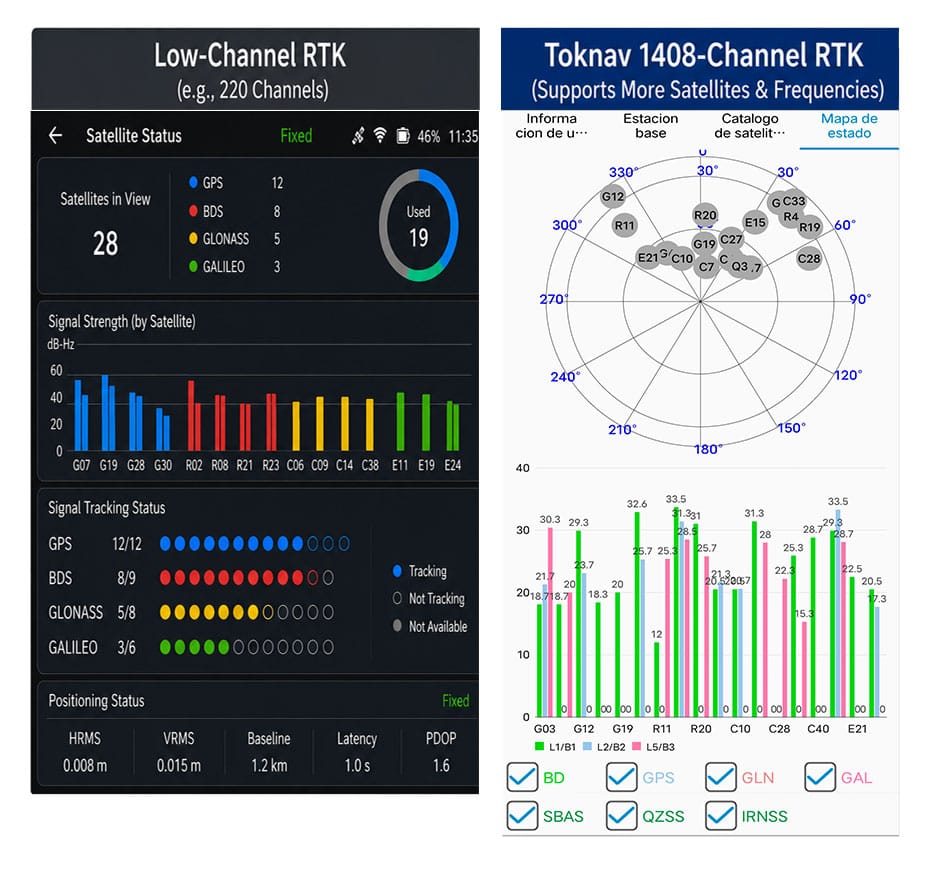
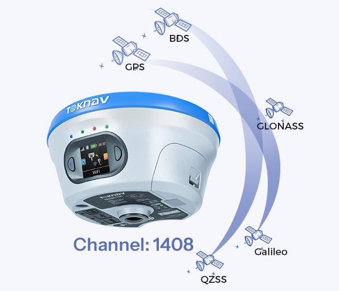
Startseite Vorteile der 1408 Kanäle: Überragende RTK-Leistung für moderne Multi-Konstellations-GNSS 11.06.2026 Vorteile der 1408 Kanäle von Toknav Vorteile der 1408 Kanäle: Warum die komplette RTK-Produktpalette von Toknav bei der Multi-Konstellations-GNSS-Positionsbestimmung führend ist 1. Grundlegendes zur Anzahl der RTK-Kanäle in GNSS-Empfängern 1.1 Was ist ein RTK-Kanal und welche Kernfunktion hat er? Jeder RTK-Kanal fungiert als unabhängige Signalverbindung zum Empfang, zur Demodulation und zur Verarbeitung von Satellitensignalen. Ein Standard-GNSS-Satellit sendet Signale auf mehreren Frequenzen aus, und jedes Signal benötigt einen eigenen Kanal. Die Gesamtzahl der RTK-Kanäle bestimmt direkt, wie viele Satellitensignale ein Empfänger gleichzeitig in Echtzeit verfolgen kann. Vergleich der RTK-Kanalanzahl bei Empfängern mit 1.400 Kanälen (GNSS) und Empfängern mit SOC-RTK-Chip 1.2 Nachteile herkömmlicher RTK-Geräte mit geringer Kanalanzahl Die meisten RTK-Geräte älterer Generation verfügen nur über 100 bis 600 Kanäle. Sie können lediglich eine geringe Anzahl von Satelliten aus begrenzten Konstellationen verfolgen. In abgeschirmten Bereichen wie städtischen Schluchten oder dichten Wäldern können sie nicht genügend Signale erfassen, was zu einer langsamen Suche und häufigen Verlusten der RTK-Position auf Baustellen führt. 1.3 Wie die Kanalanzahl mit dem Betrieb mehrerer GNSS-Konstellationen zusammenhängt Moderne GNSS-Systeme kombinieren GPS, BeiDou, Galileo, GLONASS, QZSS und SBAS. Hunderte von Satelliten und vielfältige Frequenzsignale sind am Himmel im Einsatz. RTK-Systeme mit geringer Kanalanzahl können diese Ressourcen nicht vollständig nutzen und werden so zu einem Engpass für hocheffiziente moderne Positionierungsaufgaben. 2. Warum mehr als 1.400 Kanäle für professionelles GNSS-RTK unverzichtbar sind: 2.1 Die Erweiterung um mehrere Konstellationen treibt die Nachfrage nach hoher Kanalkapazität an Globale GNSS-Konstellationen werden kontinuierlich erweitert, wobei jedes Jahr neue Satelliten und verbesserte Frequenzsignale in Betrieb genommen werden. Dies erklärt eindeutig, warum GNSS mit 1.400 Kanälen sich weltweit von einer fortschrittlichen Funktion zu einer Standardanforderung für professionelle Vermessungs- und Positionierungsgeräte entwickelt hat. 2.2 1.408 Kanäle: Vollständige Abdeckung aller gängigen GNSS-Signale Die 1.408 Kanäle von Toknav unterstützen die vollständige Verfolgung aller Konstellationen und Multifrequenzsignale. Im Gegensatz zu RTK-Geräten der Mittelklasse mit 800–1.200 Kanälen werden schwache, aber wertvolle Signale niemals außer Acht gelassen. Es nutzt die Satellitenressourcen optimal aus und schafft so die Grundlage für eine stabile Positionsbestimmung in komplexen Szenarien. 2.3 Hohe Störfestigkeit und Anpassungsfähigkeit des 1408-Kanal-Designs Signalabschirmung und Mehrwegstörungen sind im Bauwesen und in bergigen Regionen weit verbreitet. 1408 Kanäle erfassen gestreute Satellitensignale, die Geräte mit geringer Kanalanzahl übersehen. Es optimiert die geometrische Verteilung der Satelliten, um Positionsfehler zu reduzieren und die allgemeine Zuverlässigkeit zu verbessern. 2.4 Langfristiger Wert: Zukunftssicher für kommende GNSS-Upgrades – „Can Do It“ Satellitensignalsysteme werden sich im nächsten Jahrzehnt weiterentwickeln. Ein RTK-System mit 1408 Kanälen kann sich ohne Hardware-Austausch an neue Satellitensignale anpassen. Dies erspart Anwendern wiederholte Geräte-Updates und senkt die langfristigen Betriebskosten für Ingenieurteams. Technisches Datenblatt und Angebot für das 1408-Kanal-RTK-System anfordern 3. Der SOC-RTK-Chip von Toknav: Die Kernkomponente für die Unterstützung von 1408 Vollkanälen 3.1 Definition und Vorteile des integrierten SOC-RTK-Chips von Toknav Toknav stattet alle RTK-Produkte mit einem selbst entwickelten, leistungsstarken SOC-RTK-Chip aus. Dieser System-on-Chip integriert RF-Frontend, Basisband, Navigations-Engine und Prozessor in einer Einheit und ersetzt damit die sperrigen, diskreten Chipgruppen, die in herkömmlichen RTK-Empfängern verwendet werden. 3.2 Wie der SOC-RTK-Chip Datenstaus bei mehreren Kanälen löst Diskrete Chips leiden häufig unter Datenverzögerungen und -staus, wenn Hunderte von Kanälen betrieben werden. Der SOC-RTK-Chip von Toknav nutzt eine optimierte Schaltungsarchitektur und Algorithmen. Er verteilt die Signalverarbeitungsaufgaben gleichmäßig auf 1408 Kanäle, um einen Betrieb mit extrem geringer Latenz zu gewährleisten. 3.3 Energieeffizienz des SOC-RTK-Chips für tragbare RTK-Geräte Handheld-RTK-Geräte wie T5 und T5Lite erfordern lange Einsatzzeiten im Freien. Das stromsparende Design des SOC-RTK-Chips von Toknav minimiert den Energieverbrauch im Vollkanalbetrieb. Anwender profitieren von einer verlängerten Akkulaufzeit, ohne Abstriche bei der 1.408-Kanal-Leistung machen zu müssen. 3.4 Hohe Stabilität des SOC-RTK-Chips für den lang andauernden Einsatz als Basisstation Für RTK-Basisstationen der Serien tBase und NET660, die rund um die Uhr in Betrieb sind, gewährleistet der SOC-RTK-Chip einen stabilen Dauerbetrieb. Er unterstützt die langfristige Mehrkanal-Signalausgabe an Rover und gewährleistet so eine konsistente Signalübertragung für großflächige CORS-Netzwerke. SOC-RTK-Chip als Kernkomponente mit Unterstützung für 1.400 GNSS-Kanäle und hoher RTK-Kanalanzahl 4. Schnellere Satellitenerfassung und RTK-Fix: Der offensichtlichste Vorteil von 1.408 Kanälen 4.1 Beschleunigte Geschwindigkeit bei der vollständigen Satellitensuche Die Satellitenerfassung ist der erste Schritt aller RTK-Arbeitsabläufe. Die 1.408 Kanäle von Toknav scannen Signale aller Konstellationen parallel, anstatt gruppenweise zu scannen. Feldtests belegen, dass die vollständige Satellitensuche weitaus schneller abgeschlossen wird als bei herkömmlichen RTK-Empfängern mit geringer Kanalanzahl. 4.2 Verkürzte Konvergenzzeit der RTK-Fix-Lösung Ein RTK-Fix bezeichnet eine hochpräzise Positionierung im Zentimeterbereich. Die 1.408 Kanäle erfassen umfangreiche gültige Satellitendaten für die Positionsberechnung. Die große Anzahl an Signalproben beschleunigt die Datenverarbeitung und verkürzt die Zeit bis zum Erhalt einer stabilen RTK-Festsolution erheblich. 4.3 Schnelle Wiedererfassung nach vorübergehender Signalblockade Im Gelände kommt es häufig zu plötzlichen Signalblockaden durch Gebäude oder Bäume. RTK-Empfänger mit geringer Kanalanzahl benötigen Dutzende von Sekunden, um Satelliten erneut zu suchen. Die 1408 Kanäle von Toknav stellen kontinuierlich eine Verbindung zu Ersatzsatelliten her und stellen die RTK-Fix-Lösung innerhalb von Sekunden wieder her, um Arbeitsunterbrechungen zu vermeiden. 4.4 Leistungsvergleich: 1408 Kanäle vs. herkömmliches RTK mit geringer Kanalanzahl Herkömmliches RTK mit 200–500 Kanälen benötigt 60 bis 90 Sekunden, um die Suche und Positionsbestimmung abzuschließen. Das Toknav-RTK mit 1408 Kanälen benötigt für denselben Vorgang nur 20 bis 35 Sekunden. Dieser Effizienzunterschied steigert direkt die tägliche Arbeitsleistung von Vermessungs- und Kartierungsteams. Feldtest eines GNSS-RTK-Systems mit 1.400 Kanälen, hoher RTK-Kanalanzahl und SOC-RTK-Chip 5. Die gesamte RTK-Produktpalette von Toknav: Jedes Modell ist mit 1.408 GNSS-Kanälen ausgestattet 5.1 Kostengünstige und tragbare Handheld-RTK-Serie Alle leichten Handheld-RTK-Modelle verfügen über 1.408 Kanäle, darunter das preisgünstige T5Lite, das tragbare T5 und das für den Ingenieurbereich konzipierte T10Pro. Sie bieten schnelle Positionsermittlung und -fixierung für Aufgaben in der Landplanung, der ländlichen Vermessung und bei grundlegenden Bauvermessungen. 5.2 High-End-RTK-Serie für Laser, AR und Photogrammetrie Die Modelle der mittleren bis oberen Preisklasse T30, T40, T50 und ihre Pro-Versionen integrieren Laserentfernungsmessung, zwei Kameras und AR-Absteckfunktionen. Selbst mit zusätzlichen Modulen behalten sie die volle Anzahl von 1408 Kanälen bei, wodurch die Kernpositionierungsgeschwindigkeit unverändert bleibt. 5.3 Professionelle Basisstation und CORS-spezifisches RTK Die professionelle tBase-Basisstation für RTK und die NET660-Serie für den Aufbau von CORS-Systemen unterstützen 1408 Kanäle vollständig. Bei festen Basisstationen gewährleisten die zahlreichen Kanäle eine stabile Signalabdeckung für mehrere Rover in großen Ingenieurprojekten. 5.4 Spezielles RTK für Drohnen, unbemannte Fahrzeuge und Navigation NET660i-H (Positionierung und Orientierung) und NET660i-1U (unbemannte Fahrzeuge) verfügen ebenfalls über 1408 Kanäle. Bei Drohnen

Vorteile von 1408 Kanälen: Überragende RTK-Leistung für moderne GNSS-Systeme mit mehreren Konstellationen Weiterlesen »

Satellitengestützte PPP-Vermessung für entlegene Gebiete

Startseite Satellitengestützte PPP-Vermessung für abgelegene Gebiete 28.05.2026 Zusammenfassung Arbeiten Sie in unwegsamem Gelände ohne Mobilfunkempfang und ohne Vermessungspunkte in der Nähe? Dann ist Precise Point Positioning (PPP) die Lösung für Sie. Stellen Sie sich das als hochpräzises GPS vor, das keine lokale Basisstation benötigt. Stattdessen erhält Ihr Empfänger Korrekturdaten direkt von Satelliten oder aus vorab heruntergeladenen Dateien. Moderne Multiband-Empfänger können mit PPP eine Genauigkeit im Zentimeterbereich erreichen. Der Haken? Das “Aufwärmen” dauert ein paar Minuten. Dieser Leitfaden führt Sie durch die Einrichtung von PPP, vergleicht es mit anderen Methoden und gibt Tipps für erfolgreiche Vermessungen in abgelegenen Gebieten. Satellitenkorrekturen (PPP) verstehen Haben Sie sich schon einmal gefragt, wie man ohne Basisstation präzise Standorte ermitteln kann? PPP ist die clevere Antwort. Im Gegensatz zum herkömmlichen RTK, das einen Referenzempfänger in der Nähe benötigt, nutzt PPP präzise Uhr- und Umlaufbahndaten aus einem globalen Netzwerk. Dein Empfänger erhält diese Daten über ein Satellitensignal oder eine zuvor heruntergeladene Datei. Das ist ideal für Orte ohne Infrastruktur. Nach einer kurzen Initialisierung kannst du mit einer horizontalen Genauigkeit von 1–5 cm rechnen. Du nimmst eine etwas längere Wartezeit zu Beginn in Kauf und gewinnst dafür die Freiheit, absolut überall arbeiten zu können. Diagramm zum Vergleich von PPP-Vermessung und herkömmlichem RTK für hochpräzise Kartierung in abgelegenen Gebieten Ausrüstung und Konfiguration für die PPP-Vermessung Der richtige Einsatz von PPP beginnt mit der richtigen Ausrüstung. Das benötigen Sie: Einen PPP-fähigen GNSS-Empfänger: Modelle wie den Toknav T5 oder T50Pro. Diese müssen multifrequenzfähig sein, um PPP nutzen zu können. Eine gute Antenne: Eine hochwertige geodätische Antenne minimiert Fehler durch Signalreflexionen. Zuverlässige Stromversorgung: Langlebige Akkus sind ein Muss für ganztägige Arbeiten in abgelegenen Gebieten. Ein stabiles Stativ: Hält die Antenne während der kritischen Startphase vollkommen ruhig. Ein Datenerfassungsgerät: Ein robuster Controller oder ein Android-Gerät, auf dem Sie Ihre Vermessungs-App ausführen können. Bevor Sie losziehen, konfigurieren Sie Ihren Empfänger: Aktualisieren Sie die Firmware, legen Sie Ihr Koordinatensystem fest und geben Sie die Antennenhöhe ein. Wählen Sie anschließend in den Einstellungen den Modus ‘PPP’ oder ‘RTX’ aus. Falls Sie keine Satellitenverbindung haben, denken Sie daran, die Korrekturdateien für Ihre Vermessungstage im Voraus herunterzuladen. Vergleich: PPP vs. “No-Base”-RTK-Methode Funktionsweise Typische Genauigkeit Startzeit Die Vorteile Die Nachteile PPP (Satellit) Satellitensignal oder Offline-Dateien. ~1–5 cm horizontal, ~5–10 cm vertikal. Mehrere Minuten. Keine lokale Basisstation erforderlich! Funktioniert weltweit, auch ohne Mobilfunkempfang. Langsamere Startzeit. Benötigt freie Sicht zum Himmel. Erfordert möglicherweise ein Abonnement. RTK (ohne lokale Basisstation) Benötigt Internet (NTRIP) oder eine Fernfunkverbindung zu einer entfernten Basisstation. ~1–2 cm horizontal, ~2–4 cm vertikal. Sekunden bis zu einer Minute. Extrem schnell und genau, wenn die Verbindung funktioniert. Eine bewährte Methode. Völlig abhängig von einer stabilen Verbindung zu einer Basisstation oder einem Netzwerk. Funktioniert außerhalb der Netzabdeckung nicht. Genauigkeit, Konvergenz und worauf Sie achten sollten PPP ist beeindruckend genau und erreicht nach der Initialisierung oft 2–5 cm in der Horizontalen. Das entspricht in etwa dem, was Sie von RTK erwarten. Der entscheidende Unterschied ist die Konvergenzzeit – also die anfängliche Wartezeit. Normalerweise dauert dies einige Minuten, an schwierigen Standorten jedoch manchmal bis zu 15–20 Minuten. Der Empfänger benötigt diese Zeit, um die Satellitenkorrekturen zu erfassen und Mehrdeutigkeiten aufzulösen. Einige Faktoren können den Erfolg beeinflussen: Halten Sie die Antenne ruhig: Bewegen Sie die Antenne während der Initialisierung nicht. Freier Blick zum Himmel: Vermeiden Sie Bäume, Felsen oder Gebäude, die die Sicht auf die Satelliten versperren. Einstellungen prüfen: Eine falsche Eingabe der Antennenhöhe führt zu falschen Koordinaten. Verwenden Sie hochwertiges Equipment: Ein hochwertiger Multiband-Empfänger und eine entsprechende Antenne machen einen großen Unterschied. Rohdaten protokollieren: Zeichnen Sie immer Rohdaten (RINEX-Format) als Sicherung auf. So können Sie diese bei Bedarf später erneut verarbeiten. Tipps zur Fehlerbehebung bei PPP-Vermessungen aus der Ferne Sind Sie auf ein Problem gestoßen? Keine Sorge, hier sind einige Lösungen: Lässt sich das Gerät nicht starten?: Vergewissern Sie sich, dass Sie die richtige Korrekturquelle ausgewählt haben und dass das Serviceabonnement Ihres Empfängers aktiv ist. Geringe Genauigkeit?: Prüfen Sie, ob das Signal gestört wird. Begeben Sie sich an einen offeneren Ort. Falsche Koordinaten?: Geben Sie die Antennenhöhe und das Bezugssystem (z. B. WGS84) erneut ein. Allgemeiner Tipp: Geduld ist der Schlüssel zum Erfolg. Wenn es eine Weile dauert, lassen Sie den Empfänger einfach weiterarbeiten. In der Regel kommt er ans Ziel. Wenn Sie diese Schritte befolgen, können Sie selbst an den entlegensten Orten zuverlässig vermessen. PPP tauscht ein wenig anfängliche Geduld gegen ultimative Freiheit ein. Also los, kartieren Sie dieses unerforschte Gebiet! Möchten Sie mehr über Vermessung erfahren? Klicken Sie hier: Blog – TOKNAV. Haben Sie Erfahrungen aus der Praxis, die Sie teilen möchten? Kontaktieren Sie uns unter info@toknav.cn.

Satellitengestützte PPP-Vermessung für entlegene Gebiete Weiterlesen »

Kleinster RTK-Empfänger für die Vermessung: Toknavs Top-Auswahl für 2026

Home Smallest RTK Receiver for Survey: Top Toknav Picks for 2026 2026-05-16 Pocket RTK GPS: Why Size Matters in Surveying Mini GNSS Receiver Benefits for Field Work Compact survey gear has revolutionized modern surveying. The demand for the smallest RTK receiver for survey is rising, as professionals prioritize portability without sacrificing precision. A reliable pocket RTK GPS eliminates bulk, reducing fatigue during long field days. A well-built mini GNSS receiver fits in pockets or small bags, ideal for tight sites or remote missions. Toknav leads this trend, designing ultra-compact RTK receivers that redefine convenience. For modern field teams, compact survey gear is no longer optional—it’s essential for speed and accuracy. Top Toknav Mini GNSS Receiver Models smallest RTK receiver for survey Toknav T5 T5Lite mini GNSS receiver compact survey gear Toknav T5: Flagship Pocket RTK GPS The Toknav T5 stands as a top mini GNSS receiver for surveyors. Weighing just 630g with 100.5×100.5×72mm dimensions, it’s ultra-portable. Its magnesium alloy build and IP65 rating ensure durability in harsh conditions. The 1408-channel engine supports all GNSS constellations (GPS, BDS, GLONASS, GALILEO). Built-in 4G, Bluetooth, WIFI, and a radio module add versatility. As the flagship pocket RTK GPS, the T5’s 9600mAh battery delivers 16+ hours of runtime, perfect for all-day surveys. It’s the ultimate smallest RTK receiver for survey that doesn’t compromise performance. Get a Quote Now Toknav T5Lite: Budget-Friendly Compact Survey Gear For cost-conscious professionals, the Toknav T5Lite is ideal compact survey gear. At 600g and 100.5×100.5×69mm, it’s even lighter than the T5. It shares the same 1408-channel GNSS engine and multi-constellation support. The IMU module enables 60° tilt measurement with <2cm correction accuracy. Linux OS and 32GB storage ensure smooth operation. IP65 protection and 16+ hour battery life match premium models, making it a top budget pocket RTK GPS. If you need the smallest RTK receiver for survey on a budget, the T5Lite delivers exceptional value. Toknav T50 Series: Palm-Sized High-Tech RTK smallest RTK receiver for survey Toknav T50 series pocket RTK GPS compact survey gear The Toknav T50 series elevates the smallest RTK receiver for survey standard. These palm-sized units (Φ132×83mm, 770g) pack advanced features. The T50 adds a 100m laser module and AR camera for real-time stakeout, with 2.5cm 3D laser error at 5m. T50basic offers core AR and tilt functions, while T50Pro integrates photogrammetry (2–4cm accuracy at 2–15m). All models have IP68 rating, 6500mAh batteries (16+ hours), and 20Hz high-rate positioning. This mini GNSS receiver lineup redefines what pocket RTK GPS can achieve for complex projects. Explore Full Specifications Key Features of Toknav Pocket RTK GPS Receivers Unmatched Portability for Mini GNSS Receiver Toknav prioritizes compactness across all models. The T5Lite (600g) and T5 (630g) are among the lightest professional RTK receivers. The T50 series’ palm-sized design fits easily in one hand. This portability makes them perfect for urban surveys, construction layouts, and agricultural mapping where mobility is critical. No need for heavy tripods or large cases—just grab and go. When you choose the smallest RTK receiver for survey, you gain agility without losing precision. Precision That Rivals Full-Size Survey Gear Size doesn’t compromise accuracy with Toknav compact survey gear. All models deliver RTK accuracy of ±(8mm+1ppm) horizontal and ±(15mm+1ppm) vertical. Static precision reaches ±(2.5mm+1ppm) horizontal. The 1408-channel GNSS engine tracks all major constellations, ensuring reliable positioning in challenging environments like dense forests or urban canyons. IMU tilt correction (up to 60°) maintains accuracy without leveled poles. This pocket RTK GPS lineup proves small size and high precision can coexist. costumer feedback about grass sports field marking Request a Demo Today Rugged Durability for Field Conditions Field surveying demands tough equipment, and Toknav mini GNSS receiver units deliver. T5 and T5Lite feature magnesium alloy bodies with IP65 protection, withstanding dust, rain, and 1.5m drops. T50 series upgrades to IP68, offering full water and dust resistance. Operating temperatures range from -20°C to +60°C (T5/T5Lite) and -30°C to +65°C (T50 series), adapting to extreme climates. These rugged specs ensure reliability in any environment—critical for the smallest RTK receiver for survey that works as hard as you do. Long-Lasting Battery for All-Day Surveys Downtime from dead batteries is a surveyor’s worst enemy. Toknav pocket RTK GPS receivers include high-capacity batteries. T5 and T5Lite use 9600mAh batteries for 16+ hours of typical use, with static mode supporting 24-hour data collection. T50 series uses 6500mAh batteries, also delivering 16+ hours in controller network mode. Fast charging support minimizes downtime, keeping you productive all day. Great compact survey gear keeps you in the field, not at a charger. Advanced Connectivity & Smart Features: Modern surveying requires seamless connectivity, and Toknav compact survey gear excels here. All models include 4G full network access, Bluetooth, WIFI, and integrated radio modules. The radio supports multiple protocols (TRIMTALK, SOUTH, TRANSEOT) for flexible data transmission. Linux OS (ARM Cortex-A7 1.8GHz) enables efficient computing and feature expansion. T50 series adds AR cameras, laser modules, and photogrammetry for advanced workflows. This mini GNSS receiver lineup turns every field task into a streamlined operation. Why Choose Toknav for the Smallest RTK Receiver for Survey Unbeatable Size-to-Performance Ratio Toknav dominates the mini GNSS receiver market with an unbeatable size-to-performance ratio. Competitors often sacrifice features for compactness or vice versa. Toknav’s T5, T5Lite, and T50 series balance ultra-portability with professional-grade precision, durability, and smart features. Whether you need a basic pocket RTK GPS or a high-tech palm-sized unit, Toknav has a model to match your needs. For the smallest RTK receiver for survey, no other brand matches this balance. Versatility for Diverse Survey Applications From construction and land surveying to agriculture and GIS mapping, Toknav compact survey gear adapts to diverse applications. The T5Lite suits budget-focused land surveys. The T5 excels at general construction and topographic surveys. The T50 series shines in complex projects requiring AR stakeout, laser measurement, or photogrammetry. All models support standard NMEA-0183 and RTCM 3.X protocols, ensuring compatibility with existing workflows. One mini GNSS receiver can handle nearly every job site challenge. Contact Our Team for Details Trusted Quality

Kleinster RTK-Empfänger für die Vermessung: Toknavs Top-Auswahl für 2026 Weiterlesen »

Was macht GNSS in Industriequalität aus? Robustes RTK-GPS, Hochleistungs-GNSS und Vermessungswerkzeuge für den Außenbereich

Home What Defines Industrial Grade GNSS? Rugged RTK GPS, Heavy Duty GNSS & Outdoor Survey Tools 2026-04-25 What Makes GNSS Truly Industrial Grade? Industrial grade GNSS is not just about precision. It is built to survive harsh field conditions while delivering consistent RTK performance. For surveyors, construction teams, and geospatial professionals, rugged RTK GPS, heavy duty GNSS, and reliable outdoor survey tools must resist water, dust, drops, and extreme temperatures. Toknav designs its receivers around these three non-negotiable pillars: IP68 waterproof/dustproof, 1.5m drop resistance, and ultra-wide operating temperature. This blog explains how these features define real industrial quality. Core Standards of Industrial Grade GNSS Durability That Outlasts Harsh Environments True industrial grade GNSS must operate reliably where consumer devices fail. It needs full sealing against dust and water, physical shock resistance, and stable performance across extreme temperatures. These features are not optional—they are mandatory for heavy duty GNSS used daily in construction, mining, mapping, and precision agriculture. Precision Meets PersistenceIndustrial GNSS combines centimeter-level RTK accuracy with 24/7 resilience. Whether used as rugged RTK GPS for stakeout or static outdoor survey tools, it must maintain fixed solutions in rain, snow, heat, or vibration. Toknav receivers deliver ±(8mm + 1ppm) horizontal RTK accuracy without compromising toughness. Pillar 1 – IP68 Rating: Fully Waterproof & Dustproof Industrial Protection IP68 Explained – Zero Intrusion, Maximum Reliability IP68 is the highest standard for portable industrial electronics. It means 100% dust tight and submersible in water under defined pressure and time. For field crews, this eliminates downtime from rain, mud, splashes, or accidental immersion. Why IP68 Matters for Outdoor Survey Tools Jobsites expose gear to blowing dust, flooding, mud, and salt spray. Lower ratings like IP65 or IP67 only resist splashes or short immersion. Toknav’s IP68 rugged RTK GPS keeps working through storms and floods, protecting internal modules and extending service life. Toknav IP68 Implementation All Toknav high end models including T10Pro, T20Pro, T30 series, T40 series, T50 series, and NET660 series use IP68 rated magnesium alloy casings. They meet strict industrial sealing standards and are certified CE, FCC, KC, and NGS for global use. This makes them trusted heavy duty GNSS for survey and monitoring worldwide. Industrial Grade GNSS Rugged RTK GPS Heavy Duty Outdoor Survey Tools IP68 Pillar 2 – 1.5m Drop Resistance: Built for Rough Handling Industrial Strength Shock Protection Field work involves drops, knocks, pole falls, and transport vibration. A single drop can break consumer grade GNSS. Industrial receivers need structured shock absorption and reinforced housing. Toknav Drop-Tested Rugged RTK GPS Jobsites expose gear to blowing dust, flooding, mud, and salt spray. Lower ratings like IP65 or IP67 only resist splashes or short immersion. Toknav’s IP68 rugged RTK GPS keeps working through storms and floods, protecting internal modules and extending service life. Drop Resistance for Heavy Duty GNSS Workflows Whether climbing, hiking, or moving across rough terrain, users cannot avoid accidents. Toknav’s shock-proof design ensures outdoor survey tools stay functional even after repeated drops. This is industrial-grade confidence. Industrial Grade GNSS Rugged RTK GPS Heavy Duty Outdoor Survey Tools IP68 Pillar 3 – Ultra-Wide Temperature: Perform in Freezing & Scorching Heat Temperature Stability Defines Industrial Grade Performance Electronics struggle in extreme cold or heat. Consumer GNSS may shut down, lose signal, or suffer battery failure. Industrial heavy duty GNSS must maintain function across wide thermal ranges. Toknav Wide-Temp Specifications Most Toknav receivers operate from -20°C to +60°C. The T50 series extends this to -30°C to +65°C, and NET660i series supports -40°C to +85°C for CORS and remote monitoring. Storage temperature reaches -40°C to +85°C across flagship lines. H3: Reliability for Year-Round Outdoor Survey Tools From Arctic winters to desert summers, Toknav GNSS works uninterrupted. Thermal stability ensures consistent RTK tracking, IMU tilt survey, and data logging. This makes it ideal for rugged RTK GPS in global field applications. Industrial Grade GNSS Outdoor Survey Tools Wide Temperature Rugged RTK GPS How Toknav Merges Ruggedness & High Performance 1408 Channels & Full Constellation Tracking Toknav receivers support GPS, GLONASS, Galileo, BDS, QZSS, SBAS, and NavIC. With 1408 tracking channels, they maintain fast lock and stable RTK fix even in challenging environments. IMU Tilt Survey (60°) Integrated IMU enables tilt compensation up to 60°, so users collect accurate data without perfect leveling. This boosts efficiency for outdoor survey tools in steep or blocked areas. H4: Long Battery Life & Fast Charging Batteries support 16–48 hours of field use. Fast charging via USB PD and adaptive power management reduces downtime. Hot swappable batteries in T40 series keep crews working continuously. Integrated 4G, WiFi, Bluetooth & Radio Built-in 4G full netcom, WiFi, Bluetooth, and high-power radio (up to 5W) ensure strong data links. Radio range exceeds 16km in open areas, ideal for rugged RTK GPS base-rover setups. Applications – Where Toknav Industrial GNSS Excels Construction & Engineering Survey IP68, drop resistance, and wide temperature make Toknav perfect for layout, excavation, and machine control. Heavy duty GNSS performs reliably on busy, dusty, and wet construction sites. H3: Mining & Geological Survey Harsh mining conditions demand extreme durability. Toknav receivers resist dust, vibration, and impact while delivering high precision positioning for mapping and monitoring. H3: Deformation Monitoring & CORS Networks NET660 series with IP68 and  40°C to +85°C operation provides stable reference data. They are ideal for long term structural monitoring and CORS base station applications. Precision Agriculture & Autonomous Systems Wide temperature and rugged sealing support agricultural machinery control, unmanned vehicles, and smart farming. Rugged RTK GPS ensures consistent positioning in all weather. Utilities, Forestry & Environmental Survey From power lines to forests, field crews face unpredictable conditions. Toknav outdoor survey tools keep working in rain, snow, heat, and rough terrain. Why Choose Toknav Industrial Grade GNSS? Verified Industrial Durability IP68, 1.5m drop resistance, and wide-temperature performance are fully tested and certified. Toknav does not compromise on build quality. High Precision RTK Performance Centimeter-level accuracy, 1408 channels, and IMU tilt survey make Toknav competitive with premium brands—at better value. True Heavy Duty Design Magnesium alloy casing, reinforced

Was macht GNSS in Industriequalität aus? Robustes RTK-GPS, Hochleistungs-GNSS und Vermessungswerkzeuge für den Außenbereich Weiterlesen »

Ehrung der unbesungenen Helden der Präzision: Ein Tribut an die Vermessungs- und Kartierungsarbeiter am Tag der Arbeit 2026 + Toknav Official Holiday Arrangement

Home Honoring the Unsung Heroes of Precision: 2026 Labor Day tribute to surveying workers+ Toknav Official Holiday Arrangement 2026-04-25 Introduction: Why Surveying Professionals Deserve Our Deepest Respect This Labor Day If you stop to think about it, every road, every bridge, and every new urban community all starts with one essential job: professional surveying and mapping. Behind every clear coordinate and every solid engineering benchmark, there are hardworking surveying crew members working tirelessly outdoors. They face tough weather, walk long distances across rough ground, and stay on-site all year round. Simply put, they build the invisible foundation for every construction project we rely on. Labor Day isn’t just a long weekend to relax. It’s our chance to say thank you to every hardworking person who shows up, stays focused, and gets the job done well. Especially in the surveying industry, reliable field workers keep every project safe and accurate. In this warm holiday blog, we want to sincerely honor all global surveying and mapping frontline workers. We’ll also share Toknav’s official 2026 May Day holiday schedule, so all clients, partners, and survey teams can easily plan construction, orders, and technical support in advance. The Silent Dedication of Surveying and Mapping Frontline Workers: Guarding Precision with Persistence Working in all terrains, never afraid of harsh working conditions Let’s be real, office work is comfortable, but surveying work is completely different. Most surveyors spend almost all their working hours outside in the field. They climb hills, walk through muddy land, stand beside busy roads, and work on crowded construction sites every single day. No matter if it’s burning hot summer or cold windy winter, they carry survey gear, check points, collect data, and finish every measurement task on time, no excuses. Thanks to their careful repeated checks, many hidden construction risks and geological dangers are found early before problems happen. Every step they take makes construction safer, steadier, and more standard. They never chase attention or praise. They just quietly do their best to keep cities stable and projects reliable. This Labor Day, the whole Toknav team wants to send our warmest thanks and deepest respect to every frontline surveyor around the world. 2026 Labor Day tribute to surveying workers working with Toknav high-precision GNSS surveying equipment Bearing heavy responsibilities, holding precision as the core professional bottom line In surveying work, there is simply no room for mistakes. Even a tiny coordinate error can cause big rework, safety risks, and costly project losses. That’s why frontline surveyors always stay serious, patient, and focused. They double-check data, calibrate instruments many times, and record every detail carefully. Precision is not just a rule for them, it’s their daily work habit. From large highway and bridge projects to farmland surveys, city planning, and geological safety monitoring, surveyors are always the first on-site and the last to leave. With their professional skills, they lock in precise spatial data, support every construction stage, and quietly protect the safety of urban development. Truly, they are the unseen guardians behind every infrastructure project. Low-key dedication, worthy of the most sincere Labor Day praise If you work in engineering, you know it well: surveying workers are often the quiet, unsung heroes of the whole industry. No cozy offices, no air conditioning, just sun, wind, rain, and long outdoor walks every day. But think about it, without their hard work, we would have no safe roads, no standard buildings, and no complete geographic information systems at all. Labor Day is here to celebrate every ordinary person who works hard and stays dedicated. This year, we want to shine a special light on surveying frontline workers across the globe. Thank you for your patience, your strong work ethic, and your commitment to precision. Your hard work truly makes the whole industry better. How High-Quality GNSS Surveying Tools Empower Frontline Surveying Workers Efficiently We respect every laborer’s effort, and we also believe good tools should make tough field work easier. Old traditional survey tools are heavy, slow, and easy to be disturbed by bad weather or complex terrain. They make field workers more tired and waste valuable time. Luckily, modern GNSS high-precision technology has changed everything, making daily survey work faster, simpler, and much more efficient. Today’s professional GNSS survey devices offer real-time centimeter-level accuracy, stable all-weather satellite signals, and fast cloud data sharing. They work perfectly in mountains, forests, wetlands, and crowded city areas with tall buildings. Good surveying gear lowers fatigue, cuts working time, and keeps data highly accurate. Honestly, reliable GNSS tools are the best partner every field surveyor can have. Toknav: Always Empower Global Surveying Teams with Reliable GNSS Precision Solutions At Toknav, we truly understand how hard frontline surveyors work, so we always deliver reliable high-precision GNSS surveying equipment to support them. We are a friendly, professional global supplier focused entirely on high-precision GNSS positioning, Toknav GNSS RTK receiver development, and complete professional mapping positioning solution packages. For years, we have stood side by side with survey teams, engineering companies, and mapping institutions worldwide. Our goal is simple: create durable, easy-to-use, affordable GNSS equipment and provide caring, reliable technical support to lighten your field workload while optimizing every detail for real surveying scenarios. costumer feedback about grass sports field marking Every Toknav GNSS product is carefully developed and strictly tested under real harsh outdoor conditions. Our full range of RTK receivers, CORS base stations, data controllers, antennas, and survey accessories all hold CE and FCC international certifications. They feature strong anti-interference, long-lasting batteries, and steady performance, perfectly matching your all-day outdoor survey routines. Our popular T30, T40, and T50 RTK series come with practical smart functions: laser ranging, AR visual stakeout, full-system satellite reception, and smart cloud data management. With horizontal accuracy up to ±8mm and vertical accuracy up to ±15mm, these devices easily meet strict standards for railways, bridges, water conservancy, and land survey projects. Also, our self-developed tBase CORS station runs non-stop to build stable local positioning networks for large-area surveys. The built-in PPP autonomous

Ehrung der unbesungenen Helden der Präzision: Ein Tribut an die Vermessungs- und Kartierungsarbeiter am Tag der Arbeit 2026 + Toknav Official Holiday Arrangement Weiterlesen »

GNSS-Signal blockiert? Versuchen Sie diese IoT-gestützte Methode zur schnellen Neuvermessung für technische Kontrollnetze - Genauigkeit im Millimeterbereich und doppelte Effizienz

Home GNSS Signal Blocked? Try This IoT-Assisted Rapid Re-survey Method for Engineering Control Networks – Millimeter-Level Accuracy & Doubled Efficiency 2025-04-14 Friends in surveying and engineering must have encountered the same frustrating problem – control network re-survey, especially in scenarios with severe GNSS signal obstruction (such as mountainous areas, factories, and dam surroundings), which is simply “an arduous task”! Control networks are like the “eyes” of a project. Regular re-survey is essential to ensure the reliability of subsequent construction and monitoring. However, common re-survey methods on the market either have limited application scenarios or are inefficient to the point of frustration. Today, I will share a practically proven solution – an IoT-assisted rapid re-survey method for engineering control networks, which achieves millimeter-level accuracy and doubles efficiency in actual tests! IoT-Assisted Rapid Re-survey Method for Engineering Control Networks System Architecture Perception layer: The protagonist is the “remote-controlled prism” – we have modified ordinary prisms to adjust their orientation remotely, eliminating the need for manual adjustment at control points, which is the key to improving efficiency; Network transmission layer: LoRa technology is adopted. You may not be familiar with this technology, but its advantages are obvious – long transmission distance and strong anti-interference ability. Even in complex environments such as mountainous areas and dams, it can stably transmit control signals. It is worth mentioning that all Toknav’s RTK devices have the same advantages as LoRa technology and can also achieve stable transmission in complex surveying scenarios. For more information, you can check out Learn more > Application layer: It is the control software we operate, with a simple interface. It can remotely control the prism orientation, view measurement data, and realize full-process visualization, making operation very simple. The entire re-survey process is also very simple: deploy remote-controlled prisms at each control point, the operator operates the total station at a fixed position, remotely adjusts the prism orientation through the application layer software, and the total station automatically completes angle and distance measurement. No need to travel back and forth between control points, completing the task in one step. Actual Test Verification: Accuracy Uncompromised, Efficiency Doubled! Talking the talk is not enough; walking the walk is. We conducted an experiment on an actual project (the plane control network of a hydropower station dam), comparing the re-survey effects of the “IoT-assisted method” and the “total station only” method. The results were really surprising! Accuracy: The re-survey accuracy of the two methods is completely consistent, reaching sub-millimeter level, which fully meets the re-survey requirements of engineering control networks, so there is no need to worry about accuracy degradation; Efficiency: Taking working hours as the indicator, the efficiency of the IoT-assisted method is about 107% higher than that of using only the total station – simply put, a re-survey task that used to take two days can now be completed in one day, saving half the time directly! More importantly, this method does not rely on GNSS signals. As long as there is line of sight between control points (a basic requirement for traditional total station measurement), it can work normally no matter how severe the surrounding obstruction is. Many actual engineering control networks are laid out as angle-distance networks, which are just suitable for this method, with broad application prospects. Summary & Future Outlook In summary, this IoT-assisted rapid re-survey method for engineering control networks perfectly solves the pain points of traditional methods: “low efficiency, tiring labor, and limited scenarios”: No manual trips to control points to adjust prisms, with full automation, reducing labor costs and safety risks; The accuracy is consistent with that of traditional total stations, reaching sub-millimeter level, meeting engineering needs; It does not rely on GNSS signals and can easily handle scenarios with severe obstruction, with a wider scope of application; Efficiency is increased by 107%, greatly shortening the re-survey period. Of course, this method still has a small regret – it has not been applied in complex terrain (such as high mountain canyons) or ultra-large-scale control networks. In the future, we will continue to improve, and strive to verify it in more complex scenarios, so that this method can help more friends in engineering and surveying. If your project also encounters problems of GNSS signal obstruction and low re-survey efficiency, you may wish to try this method – it has been proven useful in actual tests! If you have any related questions, you can also leave a message in the comment area to communicate~ Reference: [1] Zhou Jianguo, Gan Youhuizi, Chen Yanchong. IoT-Assisted Rapid Re-survey Method and System for Engineering Control Networks[J]. Science of Surveying and Mapping, 2026, 51(02): 33-40. DOI:10.16251/j.cnki.1009-2307.2026.02.004.

GNSS-Signal blockiert? Versuchen Sie diese IoT-gestützte Methode zur schnellen Neuvermessung für technische Kontrollnetze - Genauigkeit im Millimeterbereich und doppelte Effizienz Weiterlesen »

TokNav T30 Pro RTK im Einsatz im Außenbereich

Qingming Feldvermessung: TokNav T30 Pro RTK für exakte Kartierung im Freien

Home Qingming Field Survey: TokNav T30 Pro RTK for Accurate Outdoor Mapping 2026-04-05 April brings the Qingming Festival, which is not only one of China’s 24 solar terms but also a traditional festival similar to foreign memorial days like Russia’s Radonitsa, Mexico’s Día de los Muertos, and France’s All Souls’ Day—all dedicated to honoring the deceased. Falling when the sun reaches 15° celestial longitude, Qingming is a time of mild weather and fresh greenery, ideal for field surveying, topographic exploration, and land inspection. For surveyors, this season offers great opportunities but also challenges: uneven terrain, changing weather, and long work hours. Reliable, high-performance equipment is key, and the TokNav T30 Pro RTK emerges as the perfect companion for Qingming field survey. Why Choose the TokNav T30 Pro RTK for Your Field Surveys? TokNav T30 Pro RTK working in outdoor area The TokNav T30 Pro RTK’s core strength is its high-precision positioning. It features a built-in high-precision GNSS module with 1408 high-speed channels, supporting all major satellite systems (BDS, GPS, GLONASS, Galileo, QZSS). This comprehensive coverage ensures stable positioning even in wooded areas common during Qingming outings, where satellite signals may be partially blocked. The TokNav T30 Pro RTK delivers exceptional accuracy: in RTK mode, it achieves ±(8mm+1ppm) horizontal and ±(15mm+1ppm) vertical accuracy; static mode offers ±(2.5mm+1ppm) horizontal and ±(5mm+1ppm) vertical accuracy. This precision lets surveyors collect reliable geographic data for land mapping, construction layout, or resource investigation without repeated measurements. Its AR real-time stakeout function is particularly useful for Qingming field survey. Equipped with a professional ultra-wide-angle AR camera (1/2.8-inch sensor, 1920*1080 resolution), the device overlays survey data directly onto the real-world view. This eliminates cumbersome traditional stakeout methods, letting surveyors locate target points quickly—even in unmarked areas. TokNav T30 Pro RTK’s AR stakeout Battery life is critical for long Qingming field surveys in remote areas. The TokNav T30 Pro RTK has a 7.2V, 13800mAh battery, supporting over 48 hours of continuous operation in controller network mode—enough for two full workdays on one charge. It also supports fast USB PD charging (15V/2A, 5V/3A) with adaptive current adjustment, enabling quick recharges during breaks.Built for outdoor rigors, the TokNav T30 Pro RTK has an IP68 protection rating (dust-tight and water-resistant), ideal for Qingming’s sudden light rain or damp conditions. Its magnesium alloy casing with ABS/PC top cover ensures durability, withstanding 1.5m drops at normal temperatures. Its -20°C to +60°C operating range adapts to the season’s cool mornings and warm afternoons.Connectivity is another advantage: the TokNav T30 Pro RTK supports 4G full Netcom, Bluetooth, and Wi-Fi, ensuring stable connections in remote areas. Its 4G solution, based on Linux+ARM Cortex-A7, works with all major operators, while a 5W data transmission radio (410~470MHz) enables seamless data sharing with other survey tools. For image surveys, the TokNav T30 Pro RTK offers a high-performance IS camera (1/2.6-inch, 6mm focal length, 1920*1080 resolution) with high-precision inertial navigation. Paired with Android handheld devices, it delivers accurate image measurement—perfect for large areas or hard-to-reach spots like steep slopes. Its tilt measurement function, powered by a high-precision IMU module, supports up to 60° inclination with <2cm correction accuracy. This lets surveyors work on uneven terrain without keeping the device vertical, saving time during Qingming outdoor mapping. TokNav, a leader in high-precision positioning, designs the TokNav T30 Pro RTK for surveyors’ diverse needs. It runs on a Linux system for efficient computation and expandability, with 32GB storage for daily survey data and images. Qingming field survey needs accurate, reliable, easy-to-use equipment—and the TokNav T30 Pro RTK delivers. Its precision, long battery life, AR stakeout, and rugged design make it ideal for the season. Whether for land inspection, topographic mapping, or construction layout, it ensures efficient, accurate work even in complex environments. To boost your Qingming field survey efficiency and unlock intelligent positioning, consult TokNav GNSS. Visit the TokNav T30 Pro RTK product details page to learn more. Let the TokNav T30 Pro RTK be your trusted outdoor survey assistant this Qingming.

Qingming Feldvermessung: TokNav T30 Pro RTK für exakte Kartierung im Freien Weiterlesen »

Toknav T20 Pro: Robuster Industrie-GNSS-Empfänger der Spitzenklasse für extreme Baustellen

Home Toknav T20 Pro: Top-Tier Rugged Industrial GNSS Receiver for Extreme Job Sites 2026-03-16 In surveying and construction, equipment failure isn’t just an inconvenience—it’s a threat to safety, budgets, and deadlines. The Toknav T20 Pro isn’t another GNSS receiver with impressive specs on paper; it’s a field-proven workhorse engineered to outlast the harshest conditions, including a real-world high-voltage electrocution event that would destroy any standard device. This real incident was documented in our official post: https://www.facebook.com/share/r/1CjhnsNMFZ/ Small Form Factor, Big Performance Gone are bulky high-precision GNSS devices. TOKNAV’s compact ecosystem fuses miniaturization with uncompromised performance, fitting enterprise-grade positioning into handheld tools, unmanned systems and embedded devices. The flagship T50 (Φ134mm*86mm, ≤0.78Kg) delivers centimeter-level RTK accuracy, full-system satellite tracking and intelligent features. For OEMs, our GNSS OEM board eliminates size constraints, enabling precision integration in millimeter-critical designs. TOKNAV T20Pro GNSS reciever Compact GNSS Receiver Use Cases: Real-World Applications TOKNAV’s compact solutions drive efficiency in real high-stakes projects across industries: Urban Engineering: Shanghai’s municipal team used T50 for road/bridge surveying, cutting field time by 40% in tight urban spaces with IP68 ruggedness and anti-signal-blockage performance. Geological Monitoring: Sichuan’s landslide project embedded TOKNAV RTK OEM board into mini terminals, slashing size by 60% and extending battery life to 30+ days for unattended mountain monitoring. Smart Agriculture: Xinjiang’s agricultural drone OEM integrated our high precision GNSS board, boosting crop yield by 15% with centimeter-level navigation for precision sowing/spraying. Utility Inspection: A power grid maker upgraded handheld tools with our compact modules, speeding up mountain tower inspection with tilt compensation and reliable remote signal reception. Unmatched Precision & Performance for Critical Surveys Powered by a 1408-channel multi-constellation engine, the T20 Pro tracks GPS, GLONASS, BDS, Galileo, QZSS, SBAS, and NavIC (IRNSS) to deliver fast, reliable fixes even in dense urban canyons or remote wilderness. Its RTK positioning accuracy hits ±(8mm + 1ppm) horizontal and ±(15mm + 1ppm) vertical, while static surveys reach industry-leading ±(2.5mm + 0.5ppm) horizontal and ±(5mm + 0.5ppm) vertical precision. A 60° tilt compensation feature ensures ≤2cm accuracy without perfect vertical alignment, letting you collect data faster on uneven terrain. The T20 Pro’s 1.8GHz ARM Cortex-A7 processor and Linux OS enable smooth operation and flexible customization, with 20Hz data updates and sub-1-second signal reacquisition. Its 5W internal radio extends communication to 16km in open areas, paired with global 4G LTE, Wi-Fi, and Bluetooth for seamless data sharing. A 6500mAh battery delivers 18+ hours of continuous rover use, eliminating mid-shift charging and maximizing productivity. IP68 Ruggedness: Engineered to Survive the Unsurvivable Beyond raw performance, the T20 Pro’s magnesium alloy body and IP68 ingress protection make it impervious to dust, water, vibration, and extreme temperatures (operating: -20°C to +60°C; storage: -40°C to +85°C). It withstands 1.5-meter pole drops, proving durability isn’t just a marketing claim—it’s a design mandate. But the ultimate test came on a live job site, when the entire survey kit made direct contact with high-voltage lines. This real accident is fully recorded in our Facebook post: https://www.facebook.com/share/r/1CjhnsNMFZ/ reveals the aftermath: the RTK pole melted completely, and the outer chassis was charred by an electrical explosion. Any other device would have been rendered useless, but the T20 Pro’s reinforced internal shielding protected critical circuits from heat and surge damage. https://toknavgnss.com/wp-content/uploads/2026/03/微信视频2026-03-25_163113_949.mp4 demonstrates it still powers on, locks satellites, and outputs full RTK fixes with uncompromised precision—no data loss, no downtime, no compromise. Why Professionals Choose the T20 Pro In an industry where every minute counts, the T20 Pro isn’t just a tool—it’s a safety net. Its engineering toughness, uninterrupted continuity, and manufacturing quality set it apart from competitors: Engineering Toughness: A layered internal design shields core components from electricity, heat, and mechanical shock. Uninterrupted Continuity: While other devices fail in crisis, the T20 Pro keeps delivering data to keep projects on track. Manufacturing Quality: Industrial-grade materials resist electrical and physical damage, making it a long-term investment for the toughest construction sites. A professional engineer doesn’t choose a device that looks tough on paper—they choose one that doesn’t let them down in critical moments. The T20 Pro is that device. Ready to Secure Your Indestructible GNSS Receiver? Don’t let equipment failure derail your next project. The Toknav T20 Pro is the only GNSS receiver that’s been battle-tested in the most extreme conditions and emerged victorious. Fill out our website inquiry form now to send us your questions, request a demo, or lock in your order. Our team will get back to you promptly to help you equip your job site with the reliability it deserves.

Toknav T20 Pro: Robuster Industrie-GNSS-Empfänger der Spitzenklasse für extreme Baustellen Weiterlesen »

Toknav-Hochpräzisions-GNSS-Empfänger

Toknav Hochpräzisions-GNSS-Empfänger: Die 7 wichtigsten Merkmale eines hervorragenden RTK-GNSS-Empfängers

Home Toknav High Precision GNSS Receiver: Key Features of Professional RTK GNSS Receiver 2026-03-26 Toknav High Precision GNSS Receiver As your Toknav overseas distributor technical consultant, I work with surveyors, construction teams, precision agriculture operators, robotics engineers, and OEM manufacturers every day. One of the most common questions I answer is: What truly defines a reliable, high precision positioning solution? After years of field testing, real project deployment, and supporting customers across challenging environments—from dense urban canyons to remote farmlands and harsh construction sites—I can confirm: a professional high precision GNSS receiver delivers verified accuracy, stable signal tracking, rugged durability, and easy integration. In this guide, I will share the essential key features of a high-performance  high precision GNSS receiver, using 100% real datasheet specifications from Toknav’s flagship models: T10Pro, T20Pro, T30Pro, T40Pro, and tBase. These are the same performance details I use to advise my customers to choose the right positioning solution. Toknav High Precision GNSS Receiver:Full Constellation & Multi-Frequency Tracking (1408 Channels) Full Constellation & Multi-Frequency Tracking (1408 Channels) From my experience, the biggest reason standard GNSS receivers fail in challenging environments is limited satellite and frequency support. A true high precision GNSS receiver must track all global systems and multiple bands to minimize errors and maintain availability. All Toknav receivers come with a 1408-channel high-speed measurement engine, supporting GPS, BDS, GLONASS, Galileo, QZSS, SBAS, and NavIC. Multi frequency technology effectively cancels ionospheric delay, so your Toknav high precision GNSS receiver holds a fix even under trees, near tall buildings, or in open fields with low sky visibility. Verified Centimeter-Level RTK & Static AccuracyAccuracy is non negotiable—and it must be measurable, repeatable, and backed by real datasheet values. As your technical consultant, I only recommend products with published, reliable performance.Here are the official accuracy figures from Toknav’s datasheets:RTK Mode: Horizontal ±(8mm + 1ppm), Vertical ±(15mm + 1ppm)Static Survey: Horizontal ±(2.5mm + 1ppm), Vertical ±(5mm + 1ppm)These numbers apply to all  precision GNSS receiver models, ensuring surveying and machine control tasks meet strict professional standards. Surveyors from Tanzania are using a Toknav High Precision GNSS Receiver. IMU Tilt Compensation & AR Surveying (Field-Proven Efficiency)In real field work, holding the pole perfectly vertical all day is tiring and slow. That’s why I always recommend IMU integrated Toknav high precision GNSS receiver units to my customers.Toknav’s professional models support 60° tilt measurement with correction error <2cm and AR real scene stakeout (T30Pro / T40Pro). GNSS INS fusion ensures continuous positioning during short term signal blockages. From customer feedback, this feature greatly improves efficiency for users of Toknav  GNSS receiver. A surveyor using Toknav T30Pro with tilt measurement and AR stakeout screen. 4. Industrial Rugged Design & IP68 ProtectionField equipment must survive drops, rain, dust, and extreme temperatures. I have seen many receivers fail because they were not built for real working conditions. The Toknav high precision GNSS receiver is engineered for durability: IP68 waterproof and dustproof, magnesium alloy body, 1.5m drop resistance, and operating temperature from -30°C to +65°C. Whether used in mining, agriculture, or marine environments, the Toknav high precision GNSS receiver maintains stable performance in harsh conditions. Multi-Link Communication & Long-Range UHF Radio RTK positioning depends entirely on stable correction data. As a technical consultant, I always emphasize: communication = reliability. The Toknav GNSS receiver supports fully redundant links: 4G full network, Bluetooth 5.0, WiFi, and integrated UHF radio with open area range up to 16km (T20Pro). It also supports NTRIP, RTCM3.x, and mainstream industry protocols, keeping your Toknav high precision GNSS receiver connected anywhere on site. High Update Rate & Powerful Linux Platform For industrial control, machine control, and dynamic surveying, you need fast, smooth positioning output. The Toknav high precision GNSS receiver runs on ARM Cortex A7 1.8GHz processor with Linux OS, supports 20Hz high update rate, and provides 32GB storage for data logging. This stable platform makes the Toknav high precision GNSS receiver ideal for industrial automation and professional measurement applications. All-Day Battery Life & Hot-Swappable Design Nothing stops a job faster than a dead battery. Based on real field usage, I always confirm endurance before recommending a model. The Toknav high precision GNSS receiver offers outstanding battery performance: T10Pro 6500mAh (>18 hours), T30Pro 13800mAh (up to 48 hours), and T40Pro hot swappable battery for nonstop work. Users of Toknav GNSS receiver can work a full day without mid shift charging. RTK OEM GNSS Receiver Flexibility (For Manufacturers) Many of my partners are OEMs and integrators building industrial machines, agricultural equipment, and professional terminals. For them, the RTK OEM version of Toknav high precision GNSS receiver is the core component. It features compact module form factor, standard interfaces, raw data output, and full factory support. I help customers integrate the GNSS receiver quickly and reduce development time. My Final Recommendation (As Toknav Technical Consultant) If you are looking for a reliable positioning solution, Toknav high precision GNSS receiver stands out with verified accuracy, rugged design, strong communication, and field-proven efficiency. From my years of experience supporting global clients: Whether you need a portable rover, a reliable base station, or an embedded RTK OEM version, Toknav high precision GNSS receiver provides the stability and precision professional users demand. Ready to upgrade your positioning system?Visit: Explore Toknav Full GNSS Receiver Lineup → (https://www.toknav.com/gnss-receivers) Contact your local Toknav distributor for professional technical support and project solutions. 2026-03-26 Toknav High Precision GNSS Receiver

Toknav Hochpräzisions-GNSS-Empfänger: Die 7 wichtigsten Merkmale eines hervorragenden RTK-GNSS-Empfängers Weiterlesen »

T50 GNSS-Empfänger

Kompakter GNSS-Empfänger und OEM-Karte: Miniatur-Hochpräzisionsdesign

Startseite Kompakter GNSS-Empfänger & OEM-Platine: Hochpräzises Miniaturdesign 16.03.2026 Kompakter GNSS-Empfänger & OEM-Platine In der Präzisionsortungsbranche steigt die Nachfrage nach kompakten GNSS-Empfängern und leistungsstarken GNSS-OEM-Platinenlösungen rasant an. TOKNAV definiert kompakte Positionierung neu – mit ultrakleinen Formfaktoren, RTK-Leistung in Industriequalität, vollständiger Unterstützung mehrerer Konstellationen und vielseitigen Anschlussmöglichkeiten. Unsere hochpräzisen GNSS-Platinen und kompakten Empfänger bieten professionelle Präzision und ermöglichen Herstellern und Endnutzern eine platzsparende Positionierung auf höchstem Niveau. Kleiner Formfaktor, große Leistung Vorbei sind die Zeiten sperriger, hochpräziser GNSS-Geräte. Das kompakte Ökosystem von TOKNAV verbindet Miniaturisierung mit kompromissloser Leistung und integriert Positionierung auf Unternehmensniveau in Handgeräte, unbemannte Systeme und eingebettete Geräte. Das Flaggschiff T50 (Φ134 mm × 86 mm, ≤ 0,78 kg) bietet RTK-Genauigkeit im Zentimeterbereich, Satellitenverfolgung im gesamten System und intelligente Funktionen. Für OEMs beseitigt unsere GNSS-OEM-Platine Größenbeschränkungen und ermöglicht eine präzise Integration in Designs, bei denen es auf Millimeter ankommt. Anwendungsbeispiele für kompakte GNSS-Empfänger: Anwendungen in der Praxis: Die kompakten Lösungen von TOKNAV steigern die Effizienz in realen, hochkritischen Projekten branchenübergreifend: Stadtbau: Das städtische Team von Shanghai setzte den T50 für die Vermessung von Straßen und Brücken ein und verkürzte die Arbeitszeit vor Ort um 40% in beengten städtischen Räumen – dank IP68-Zertifizierung und Schutz vor Signalblockaden. Geologische Überwachung: Im Rahmen eines Erdrutschprojekts in Sichuan wurde die TOKNAV RTK-OEM-Karte in Mini-Terminals eingebaut, wodurch die Größe um 60% reduziert und die Akkulaufzeit für die unbeaufsichtigte Bergüberwachung auf über 30 Tage verlängert wurde. Intelligente Landwirtschaft: Ein OEM-Hersteller von Agrardrohnen aus Xinjiang integrierte unsere hochpräzise GNSS-Karte und steigerte den Ernteertrag um 15% durch zentimetergenaue Navigation für präzises Säen und Sprühen. Inspektion von Versorgungsnetzen: Ein Hersteller von Stromnetzen rüstete seine Handgeräte mit unseren kompakten Modulen auf und beschleunigte so die Inspektion von Bergmasten durch Neigungskompensation und zuverlässigen Fernsignalempfang. Ein Schritt vorwärts in der Mission von TOKNAV – Technische Vorteile der GNSS-OEM-Boards Die RTK-OEM-Boards und hochpräzisen GNSS-Boards von TOKNAV sind für eine nahtlose Integration ausgelegt und laufen auf einer Linux+ARM-Cortex-A7-Plattform, die effiziente Rechenleistung und skalierbare Funktionalität bietet. Das Modul mit 1.408 Kanälen unterstützt Signale aller Konstellationen (BDS/GPS/GLONASS/Galileo/QZSS/SBAS/NavIC) und gewährleistet so eine unterbrechungsfreie Positionsbestimmung in städtischen Schluchten, Wäldern und abgelegenen Gebieten. Die für den industriellen Einsatz geeignete Schutzklasse IP68, der Betriebsbereich von -30 °C bis +65 °C und vielseitige Konnektivitätsoptionen (4G/Bluetooth/WLAN/Funk) eignen sich für raue Umgebungen, während vorintegrierte Neigungskompensation, AR-Absteckung und Lasermessung die Entwicklungskosten für Hersteller senken. Ein Schritt vorwärts in der Mission von TOKNAV – Spezifikationen der hochpräzisen GNSS-Karte Präzision ist das Fundament unserer OEM-Karten mit branchenführenden Spezifikationen: RTK-Genauigkeit (horizontal: ±(8 mm + 1 ppm), vertikal: ±(15 mm + 1 ppm)); Genauigkeit im statischen Modus (horizontal: ±(2,5 mm + 1 ppm), vertikal: ±(5 mm + 1 ppm)); Wiedererfassung in <1 s, RTK-Initialisierung in <10 s und eine Positionsbestimmungsfrequenz von 20 Hz. Die ARM Cortex-A7/Linux-Hardware, 8 GB Speicher und ein 7,4-V-Akku mit 6500 mAh (über 16 Stunden Betriebszeit) sorgen für stabile Leistung. Das Gehäuse aus Magnesiumlegierung, die Fallfestigkeit bis zu 1,5 m und die Schutzart IP68 gewährleisten Zuverlässigkeit auch unter extremen Umgebungsbedingungen. Integrationsleitfaden für Gerätehersteller TOKNAV vereinfacht die Integration von hochpräzisen GNSS-Boards und kompakten Empfängern für Hersteller durch standardisierte Protokolle (NMEA-0183/RTCM3.X) und universelle Schnittstellen, die Kompatibilitätsbarrieren beseitigen. Der Prozess: Auswahl maßgeschneiderter Module → Nutzung der technischen Dokumentation zur Hardware-/Parameterkonfiguration → Aktivierung der Kernfunktionen. Unsere Linux-Plattform unterstützt die individuelle Anpassung und bietet dedizierten technischen Support für die Firmware-Einrichtung, Fehlerbehebung und Optimierung. Alle Ressourcen finden Sie auf unserer OEM-/Modul-Seite. TOKNAV-Modulpalette Unser Angebot deckt alle Anforderungen an hochpräzise Positionsbestimmung ab: den tragbaren Empfänger T50 für Vermessungen im Gelände sowie eine vielfältige Auswahl an GNSS-OEM-Platinen und RTK-OEM-Platinen in verschiedenen Formfaktoren und Leistungsklassen. Jedes Produkt erfüllt die Standards für Miniaturisierung, professionelle Genauigkeit, robuste Haltbarkeit und nahtlose Konnektivität und verfügt über ein elektronisches Zaunsystem zur Einhaltung regionaler Vorschriften sowie umfassenden Hersteller-Support für Updates und Wartung. Fazit & Aufruf zum Handeln Die kompakten GNSS-Empfänger und GNSS-OEM-Boards von TOKNAV verbinden Miniaturdesign mit leistungsstarker Technik und widerlegen damit den Mythos, dass geringe Größe mit Einbußen bei der Präzision einhergeht. Wir bieten RTK-Genauigkeit im Zentimeterbereich, Zuverlässigkeit durch Unterstützung mehrerer Konstellationen und industrielle Robustheit für Anwendungen mit begrenztem Platzangebot. Ob Sie nun im Außendienst tätig sind oder als OEM-Innovator arbeiten – TOKNAV bietet maßgeschneiderte Positionierungslösungen. Sind Sie bereit, Ihre Positionierungsfähigkeiten auf ein neues Niveau zu heben? Besuchen Sie unsere Produktseite, um unser Sortiment zu entdecken, technische Daten herunterzuladen und sich mit unserem Team bezüglich einer maßgeschneiderten Integration in Verbindung zu setzen – treiben Sie Ihre Innovation mit der kompakten, hochpräzisen GNSS-Exzellenz von TOKNAV voran.

Kompakter GNSS-Empfänger und OEM-Karte: Miniatur-Hochpräzisionsdesign Weiterlesen »

Werden Sie TOKNAV-Vertriebspartner weltweit!

Mit einer bewährten Erfolgsbilanz in der Vermessungsbranche suchen wir jetzt nach leidenschaftlichen Vertriebsmitarbeitern, die an unserer globalen Erfolgsgeschichte teilhaben möchten.