
LiDAR and Reality Capture

LiDAR scanner, SLAM mapping and reality capture content for 3D surveying and geospatial documentation.

best rtk & slam 2026

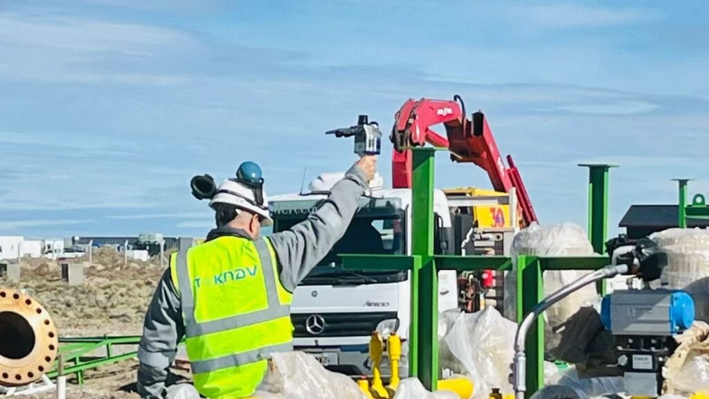
TOKNAV RTK & SLAM Solutions Drive Surveying Success in Argentina – tBase, T45 & TSR20 Field Performance

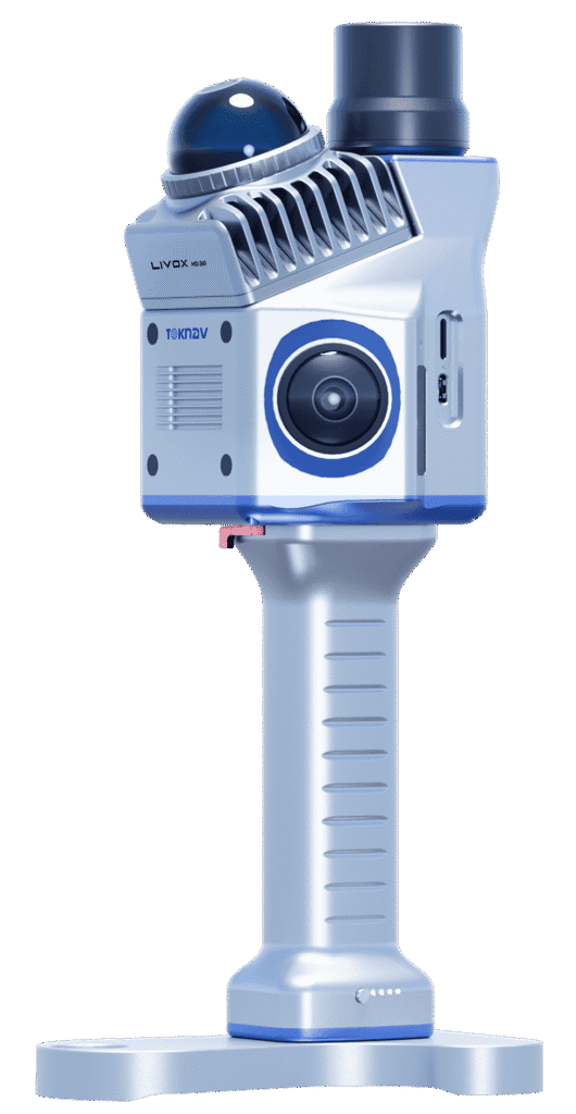
Home TOKNAV RTK & SLAM Solutions Drive Surveying Success in Argentina – tBase, T45 & TSR20 Field Performance 2026-04-20 Argentina is a country of incredible geographic diversity: from the fertile plains of the Pampas to the rugged slopes of the Andes, from dense forests in the north to urban centers like Buenos Aires, and from large-scale agriculture to heavy construction and infrastructure projects. For surveyors, engineers, construction managers, and agricultural teams across Argentina, reliable high-precision positioning equipment is not just useful—it is essential. Teams need tools that deliver centimeter-level accuracy, work reliably under tree cover or in city canyons, survive harsh weather, and fit real-world workflows. Today, we are proud to share real feedback, photos, and video results from our authorized TOKNAV dealer in Argentina, who has deployed TOKNAV’s flagship products: the tBase GNSS base station, T45 multi-functional RTK receiver, and TSR20 handheld SLAM LiDAR scanner. These tools are proving themselves daily across Argentine projects, and they are quickly becoming the go-to choice for professionals who want the best RTK & SLAM 2026 has to offer, without paying premium international prices. Why TOKNAV Is the Top Choice for Argentine Surveyors & Construction Teams Discover the Best RTK & SLAM 2026 for Your Projects TOKNAV is a global leader in high-precision GNSS, RTK, and SLAM mapping solutions, designed specifically for professional land surveying, construction, precision agriculture, infrastructure inspection, and digital twin creation. Unlike consumer-grade GPS tools, TOKNAV builds industrial-grade hardware with full-constellation satellite tracking, advanced IMU integration, and multi-mode data processing. For Argentine users, this means stability where other receivers fail: under heavy canopy, on steep slopes, in dusty construction zones, and under changing weather conditions. The combination of T45 RTK receiver, tBase base station, and TSR20 SLAM scanner creates a complete end-to-end positioning workflow that covers every job—from static control surveys and topographic mapping to 3D reality capture and construction stakeout. Argentine professionals report fewer dropouts, faster fix times, longer battery life, and easier operation than competing brands they have used in the past. For small survey firms, large construction companies, agricultural operations, and government projects, TOKNAV delivers performance and value that aligns perfectly with local needs. TOKNAV RTK Products: T45 & tBase Base and Rover Kit for High-Precision Work When teams in Argentina search for the best RTK GPS receiver 2026, they prioritize three non-negotiable features: proven accuracy, rugged build quality, and strong signal performance in difficult environments. The TOKNAV T45 and tBase affordable RTK base and rover kit checks every box. Built for professional use, the T45 is a portable, powerful GNSS RTK receiver powered by a high-performance Linux platform and equipped with 1408 channel GNSS tracking. This high channel count allows ultra-fast satellite acquisition and stable tracking even in dense forests, urban canyons, or mountain regions where signals are often weak or blocked. For Argentine surveyors working in remote areas or challenging terrain, this means fewer interruptions, faster RTK fixed solutions, and more productive hours in the field. Best RTK GPS Receiver 2026 for Argentina’s Diverse Terrain The best RTK GPS receiver 2026 must perform reliably across Argentina’s varied landscapes, and the T45 delivers. It supports full multi-constellation tracking: GPS, GLONASS, Galileo, BeiDou, and other global satellite systems. This full coverage ensures that the receiver can lock onto signals no matter where the job takes it. The tBase professional GNSS base station is built for long-range, stable differential coverage. With a high-power internal radio, it provides consistent communication over long distances—ideal for large agricultural fields, road construction, mining surveys, and infrastructure projects common across Argentina. Together, the T45 and tBase form a complete RTK base and rover kit that supports both UHF radio and 4G network connections using NTRIP and CORS. This dual-link design ensures constant RTK corrections even in rural areas with limited internet, a major advantage for teams working far from urban centers. TOKNAV T45 & tBase RTK Base Rover Kit in Argentina Survey IMU Tilt Compensation RTK for Faster Survey on Slopes Much of Argentina’s land is sloped—from vineyards in Mendoza to road construction along mountainous areas. Traditional RTK receivers require surveyors to perfectly level the pole for every measurement, slowing work and increasing fatigue. The TOKNAV T45 eliminates this problem with IMU tilt compensation RTK technology, delivering accurate measurements even when tilted up to 60 degrees. The correction error remains under 2 centimeters, meeting strict accuracy standards for cadastral surveying, construction layout, and infrastructure work. Argentine field crews report reducing field time by 30–40% on sloped projects because they no longer need to stop and level the pole repeatedly. This IMU tilt compensation feature also eliminates “fly points” common with older equipment, ensuring clean, reliable data that imports smoothly into CAD and GIS software. For any team working on uneven ground, this feature alone makes TOKNAV a smarter choice. IP68 Rugged RTK Receiver for Extreme Environments Argentina’s climate varies widely, from extreme heat in the northern plains to cold, wet conditions in Patagonia and high-altitude mountain zones. Survey equipment must resist dust, moisture, drops, and temperature changes. Both the T45 receiver and tBase base station feature IP68 rugged RTK receiver construction with a durable magnesium alloy casing. They are fully waterproof, dustproof, and shock-resistant, able to withstand drops from 1.5 meters. The operating temperature range spans from -30°C to +65°C, making them suitable for summer heat and winter cold alike. The TSR20 SLAM scanner shares this rugged build quality, operating reliably from -20°C to +55°C. For Argentine field crews working long days in harsh conditions, this rugged design means less downtime, fewer repairs, and a lower total cost of ownership over time. TSR20 Handheld SLAM Scanner: 3D Mapping in GNSS-Denied Areas in Argentina Many Argentine projects require mapping in areas where GNSS signals are weak or unavailable: building interiors, underground parking facilities, tunnels, dense forests, and urban canyons surrounded by tall buildings. This is where the TOKNAV TSR20 handheld SLAM LiDAR scanner becomes indispensable. Designed for SLAM laser scanner performance without relying on satellite signals, the TSR20 captures precise 3D point clouds
TOKNAV RTK & SLAM Solutions Drive Surveying Success in Argentina – tBase, T45 & TSR20 Field Performance Read More »

SLAM-Powered LiDAR Solutions: Redefining 3D Reality Capture for Global Projects

Home SLAM-Powered LiDAR Solutions: Redefining 3D Reality Capture for Global Projects 2026-04-18 In today’s fast-evolving industries, digital twins, smart infrastructure, BIM, industrial inspection, and cultural heritage preservation demand high-efficiency, high-accuracy, and universally adaptable 3D reality capture. Traditional surveying and mapping methods depend heavily on GNSS signals, suffer from low field efficiency, and struggle to perform in complex, confined, or signal-blocked environments. To address these global challenges, Toknav introduces two professional, field-proven SLAM-Powered LiDAR Solutions: the TSR20 Handheld SLAM LiDAR Scanner and the TSL150 Terrestrial Laser Scanner. Built for international users, these integrated systems combine mobility, precision, and intelligent workflow to set new standards for real world 3D reconstruction across continents, sectors, and mission-critical projects. SLAM Powered LiDAR Solutions: Toknav TSR20 Handheld Scanner in Field Use Core Challenges in Global 3D Reality Capture Projects around the world face three persistent bottlenecks: GNSS-denied environments including indoor facilities, underground structures, tunnels, dense urban canyons, forests, and enclosed spaces block conventional positioning systems. Speed and accuracy are difficult to balance — mobile scanners often lack precision, while static terrestrial scanners are slow to deploy and require heavy post-processing. Complex, labor-intensive workflows extend project timelines, increase operational risks, and drive up overall costs. The Toknav TSR20 and TSL150 solve these problems in tandem: mobile SLAM scanning for broad, rapid coverage and static terrestrial scanning for ultra-high-precision details. Together, they form a complete end-to-end SLAM-Powered LiDAR Solutions for professional 3D modeling and spatial data delivery. TSR20 Handheld SLAM LiDAR Scanner: Mobility and Real-Time Mapping Excellence Designed for dynamic, on-the-move data acquisition, the TSR20 integrates advanced SLAM algorithms with the Livox Mid-360 LiDAR sensor to generate dense, precise 3D point clouds in real time—with or without GNSS coverage. Key Advantages Multi-Mode SLAM PerformanceSupporting SLAM, RTK-SLAM, and PPK-SLAM modes, the system fuses LiDAR, high-frequency IMU, and multi-constellation GNSS to deliver ≤3cm relative accuracy and ≤5cm absolute accuracy, fully satisfying professional BIM, digital twin, and engineering survey requirements. Unlimited Environmental AdaptabilityWith 360° non-repetitive scanning, a 40m measurement range, and strong point penetration, the TSR20 performs reliably in underground spaces, interior rooms, stairwells, parking facilities, power line corridors, and low-canopy forests. Ultra-Lightweight and ErgonomicAt only 1.0kg with a compact form factor, the scanner allows comfortable, all-day handheld operation by a single user. Its rugged design and low power consumption ensure stable performance in harsh field conditions. True-Color 3D RealityDual 20MP ultra-wide cameras with 200° fields of view capture synchronized image data, producing photorealistic, textured 3D models with sharp geometric and visual detail. All-in-One Workflow64GB internal storage plus 128GB expandable SD card, wireless WiFi data transfer, and dedicated post-processing software enable seamless acquisition, visualization, classification, filtering, and modeling in one unified pipeline. Ideal Applications Underground space mapping, indoor 3D reconstruction, building surveying, power line inspection, forestry mapping, emergency response mapping, and large-area mobile survey projects. TSL150 Terrestrial Laser Scanner: Millimeter-Precision Static Scanning Engineered for high-precision static measurement, the TSL150 combines long-range laser ranging, professional HDR imaging, and on-board intelligent processing to deliver survey-grade results for demanding engineering and documentation tasks. Key Advantages Millimeter-Level AccuracyWith a maximum range of 150m, the system achieves 2mm accuracy@50m and 3mm accuracy@100m, making it ideal for structural monitoring, heritage digitization, precise BIM reverse engineering, and industrial metrology. High-Speed Data CaptureA 1.2MHz pulse repetition rate and 100 lines/sec scanning speed drastically reduce field time while producing dense, high-quality point clouds. On-Site Intelligent ProcessingBuilt-in software supports real-time point cloud registration, automatic multi-station adjustment, and visual measurement, minimizing office post-processing and ensuring data integrity before leaving the site. Compact and Flexible DeploymentWeighing just 3.3kg with a small footprint, the TSL150 supports both upright and inverted mounting for use in confined spaces, elevated positions, and challenging access areas. Its IP54 rating ensures durability in tough environments. Multi-Sensor FusionA 100MP HDR panoramic camera, MEMS IMU, and multi-GNSS support deliver precisely georeferenced, color-rich point clouds ready for professional mapping and modeling. SLAM-Powered LiDAR Solutions: Toknav TSL150 Terrestrial Laser Scanner Ideal Applications Cultural heritage preservation, building deformation monitoring, high-precision BIM modeling, pipeline surveying, earthwork calculation, landslide investigation, and industrial facility measurement. The Ultimate Combination: TSR20 + TSL150 For global 3D reality capture projects, the TSR20 handheld SLAM scanner and TSL150 terrestrial scanner complement each other perfectly: The TSR20 rapidly covers large, complex, or hard-to-reach areas with efficient mobile scanning. The TSL150 delivers millimeter-level detail for critical structures, key components, and high-precision documentation. Combined, they provide full-coverage, high-accuracy 3D modeling with significantly reduced time, labor, and cost. This powerful pairing supports digital construction, smart infrastructure, industrial digital transformation, and heritage conservation projects worldwide. SLAM-Powered LiDAR Solutions: TSR20 & TSL150 Combined Workflow Why Choose Toknav? Professional SLAM and sensor fusion algorithms ensure stable, high-precision performance in diverse environments. Global design supports multi-GNSS compatibility and operates reliably across different climate and field conditions. End-to-end workflow integrates acquisition, processing, and modeling to reduce complexity and improve efficiency. Rugged, portable hardware is built for daily professional use in international field projects. Global customer support ensures smooth deployment, training, and long-term reliability. Explore Toknav 3D Reality Capture Solutions Discover how the TSR20 and TSL150 can improve accuracy, speed, and efficiency for your projects.Search keywords: Toknav TSR20, Toknav TSL150, handheld SLAM LiDAR, terrestrial laser scanner, 3D reality capture, SLAM scanning system. Toknav provides professional, reliable, and future-ready SLAM-Powered LiDAR Solutions to turn physical spaces into precise, usable digital assets.

SLAM-Powered LiDAR Solutions: Redefining 3D Reality Capture for Global Projects Read More »

Toknav TSR20 Handheld LiDAR Scanner

TOKNAV TSR20 Handheld LiDAR Scanner In-Depth Review

Home TOKNAV TSR20 Handheld LiDAR Scanner In-Depth Review The Ultimate Solution for High-Precision Mapping in 2026 Are cumbersome traditional survey tools, insufficient data accuracy, and poor adaptability between indoor and outdoor work slowing you down?Based on three months of rigorous field testing, the TOKNAV TSR20 Handheld LiDAR Scanner is redefining portable 3D mapping. This review details how its ultra-lightweight 1.0kg design, ≤3cm relative accuracy, and multi-mode mapping capabilities tackle critical industry challenges. Furthermore, we include exclusive application cases—from integrating Ground-Penetrating Radar for underground utility detection to leveraging GPS RTK for power line surveys—to support your decision-making. How the TSR20 Addresses Core Industry Pain Points Exploring the Advantages of the TSR20 Handheld LiDAR Scanner Pain Point 1: Low Efficiency Caused by Bulky EquipmentUnlike traditional static scanners often exceeding 10kg and requiring tripods, the TSR20 weighs only 1.0kg with compact dimensions (16.5×12.0×32.4cm), enabling true single-handed operation. This portability facilitates efficient automated scanning. Consequently, our tests recorded a 50% increase in single-person daily output. Notably, testers reported zero fatigue even after two hours of continuous use in stairwells.Pain Point 2: Incomplete Data Capture in Complex EnvironmentsEquipped with a Livox Mid-360 LiDAR sensor, a 40m range, and a 200,000 pts/sec acquisition rate, the TSR20 ensures comprehensive detail capture in low-light or cluttered scenes. For instance, during forestry surveys, the point cloud loss rate under dense canopies remained below 5%.Pain Point 3: The Trade-off Between Accuracy and SpeedThe scanner’s multi-mode mapping (SLAM/RTK-SLAM/PPK-SLAM) allows seamless switching to balance precision and pace: SLAM Mode:​ Maintains ≤5cm absolute accuracy in GNSS-denied areas like indoors. RTK-SLAM Mode:​ Achieves ≤2cm outdoor accuracy when paired with a TOKNAV Net660i base station.In a real-world building facade survey, the margin of error was merely ±1.5cm—significantly surpassing the industry average of ±5cm Interpreting Core Specifications: A Data-Driven Professional Guide The TSR20’s specifications translate into measurable, real-world reliability. Here are the key takeaways: Accuracy You Can TrustIn a BIM project, its ≤3cm relative accuracy met LOD 300 (detailed design) requirements. Additionally, third-party testing per ISO 17123-5 showed a high error distribution concentration of up to 98%.Superior Stability in MotionA 200Hz POS update rate ensures high dynamic attitude accuracy (Pitch: 0.05°, Heading: 0.03°). Compared to competitors using 100Hz systems, the TSR20 reduces motion jitter error by approximately 60%.Extended Endurance for Demanding JobsWith a 25W low-power design, it supports 4 hours of runtime—extendable to 8 hours with a dual-battery pack. Even in a -10°C test, the point cloud frame loss rate was <0.1%, outperforming most rivals (avg. 3%). Pro Tip:​ Beginners should start with SLAM mode, while professionals seeking centimeter-level results should prioritize RTK-SLAM. Application Cases: Solving Real-World Problems These cases come from active projects, complete with data and operational tips. Case 1: Underground Space Surveying for Mine Safety Challenge:​ GPS signal failure caused critical data gaps in tunnel deformation monitoring. Solution:​ Using SLAM mode with high-penetration lasers generated a detailed 3D model for displacement analysis. Result:​ A 100m tunnel segment was scanned in 30 minutes, achieving 95% accuracy for early hazard warnings. Case 2: Safer, More Efficient Power Line Inspection Challenge:​ Traditional high-altitude manual inspections are both costly and risky. Technique:​ Dual 20MP cameras enabled synchronized image capture and automatic damage identification. Impact:​ A 2025 Green Grid project reported 70% lower labor costs and triple the inspection efficiency. Case 3: Building Digitalization for Heritage Conservation Innovation:​ Merging TSR20 point clouds with historical archives helps reconstruct architectural evolution. Outcome:​ At a Qing Dynasty residence in Hangzhou, scans revealed hidden structural cracks, providing a solid foundation for restoration plans. Getting Started: A Practical, Replicable Workflow Optimal Mode Selection Strategy For Indoors/Underground:​ Use SLAM mode (no GNSS required). For Open Outdoors:​ Activate RTK-SLAM for maximum accuracy. Crucial Avoidance:​ Do not force RTK mode in signal-blocked areas to prevent data jumps. Effective Data Acquisition Techniques Maintain a steady walking speed of about 0.5m/s and navigate around obstacles carefully. Use a phone mount for real-time preview to ensure complete target coverage. Post-Processing Optimization Tips Utilize software like PointCloudCreator for auto-filtering to reduce noise effectively. Export data in .las format to ensure seamless compatibility with mainstream BIM platforms. Solving Your Surveying Challenges, Together The TSR20 is more than a tool; it is a catalyst for intelligent surveying. By harmonizing portability, environmental adaptability, and an integrated workflow, it balances the critical triangle of accuracy, efficiency, and cost.If you are evaluating equipment, share your specific scenario in the comments (e.g., “Which mode is best for mine monitoring?”) and we’ll provide tailored advice.

TOKNAV TSR20 Handheld LiDAR Scanner In-Depth Review Read More »

Become TOKNAV global distributors!

With a proven track record in surveying industry, we’re now looking for passionate distributors to join our global success story.