
LiDAR and Reality Capture

LiDAR scanner, SLAM mapping and reality capture content for 3D surveying and geospatial documentation.

أفضل أنظمة RTK وSlam لعام 2026

تقود حلول TOKNAV RTK و SLAM نجاح المسح في الأرجنتين - الأداء الميداني لـ tBase و T45 و TSR20

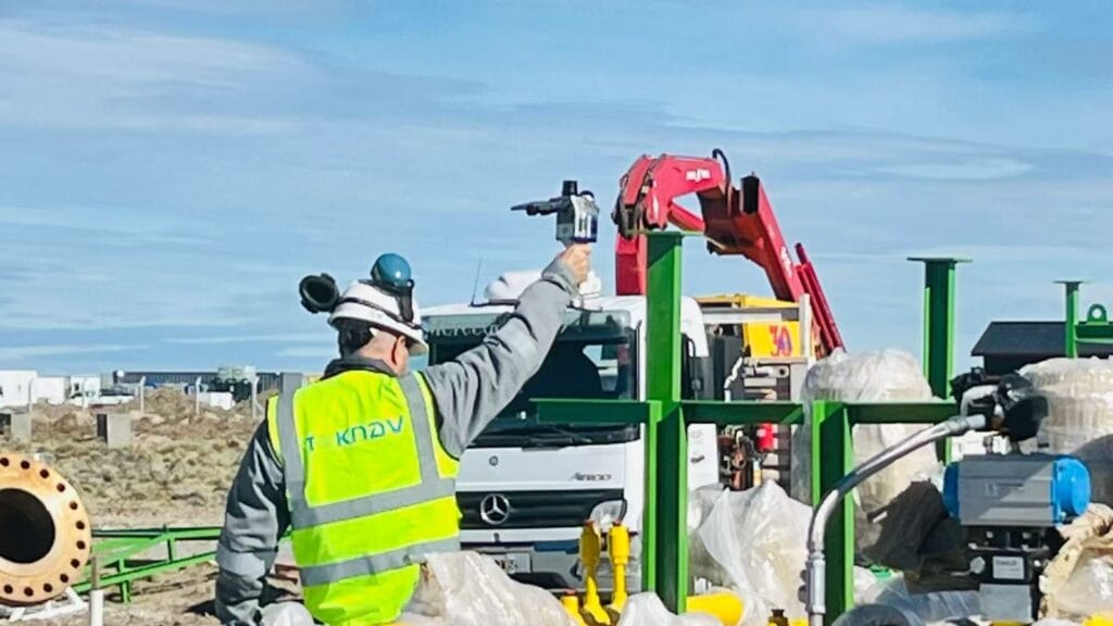
Home TOKNAV RTK & SLAM Solutions Drive Surveying Success in Argentina – tBase, T45 & TSR20 Field Performance 2026-04-20 Argentina is a country of incredible geographic diversity: from the fertile plains of the Pampas to the rugged slopes of the Andes, from dense forests in the north to urban centers like Buenos Aires, and from large-scale agriculture to heavy construction and infrastructure projects. For surveyors, engineers, construction managers, and agricultural teams across Argentina, reliable high-precision positioning equipment is not just useful—it is essential. Teams need tools that deliver centimeter-level accuracy, work reliably under tree cover or in city canyons, survive harsh weather, and fit real-world workflows. Today, we are proud to share real feedback, photos, and video results from our authorized TOKNAV dealer in Argentina, who has deployed TOKNAV’s flagship products: the tBase GNSS base station, T45 multi-functional RTK receiver, and TSR20 handheld SLAM LiDAR scanner. These tools are proving themselves daily across Argentine projects, and they are quickly becoming the go-to choice for professionals who want the best RTK & SLAM 2026 has to offer, without paying premium international prices. Why TOKNAV Is the Top Choice for Argentine Surveyors & Construction Teams Discover the Best RTK & SLAM 2026 for Your Projects TOKNAV is a global leader in high-precision GNSS, RTK, and SLAM mapping solutions, designed specifically for professional land surveying, construction, precision agriculture, infrastructure inspection, and digital twin creation. Unlike consumer-grade GPS tools, TOKNAV builds industrial-grade hardware with full-constellation satellite tracking, advanced IMU integration, and multi-mode data processing. For Argentine users, this means stability where other receivers fail: under heavy canopy, on steep slopes, in dusty construction zones, and under changing weather conditions. The combination of T45 RTK receiver, tBase base station, and TSR20 SLAM scanner creates a complete end-to-end positioning workflow that covers every job—from static control surveys and topographic mapping to 3D reality capture and construction stakeout. Argentine professionals report fewer dropouts, faster fix times, longer battery life, and easier operation than competing brands they have used in the past. For small survey firms, large construction companies, agricultural operations, and government projects, TOKNAV delivers performance and value that aligns perfectly with local needs. TOKNAV RTK Products: T45 & tBase Base and Rover Kit for High-Precision Work When teams in Argentina search for the best RTK GPS receiver 2026, they prioritize three non-negotiable features: proven accuracy, rugged build quality, and strong signal performance in difficult environments. The TOKNAV T45 and tBase affordable RTK base and rover kit checks every box. Built for professional use, the T45 is a portable, powerful GNSS RTK receiver powered by a high-performance Linux platform and equipped with 1408 channel GNSS tracking. This high channel count allows ultra-fast satellite acquisition and stable tracking even in dense forests, urban canyons, or mountain regions where signals are often weak or blocked. For Argentine surveyors working in remote areas or challenging terrain, this means fewer interruptions, faster RTK fixed solutions, and more productive hours in the field. Best RTK GPS Receiver 2026 for Argentina’s Diverse Terrain The best RTK GPS receiver 2026 must perform reliably across Argentina’s varied landscapes, and the T45 delivers. It supports full multi-constellation tracking: GPS, GLONASS, Galileo, BeiDou, and other global satellite systems. This full coverage ensures that the receiver can lock onto signals no matter where the job takes it. The tBase professional GNSS base station is built for long-range, stable differential coverage. With a high-power internal radio, it provides consistent communication over long distances—ideal for large agricultural fields, road construction, mining surveys, and infrastructure projects common across Argentina. Together, the T45 and tBase form a complete RTK base and rover kit that supports both UHF radio and 4G network connections using NTRIP and CORS. This dual-link design ensures constant RTK corrections even in rural areas with limited internet, a major advantage for teams working far from urban centers. TOKNAV T45 & tBase RTK Base Rover Kit in Argentina Survey IMU Tilt Compensation RTK for Faster Survey on Slopes Much of Argentina’s land is sloped—from vineyards in Mendoza to road construction along mountainous areas. Traditional RTK receivers require surveyors to perfectly level the pole for every measurement, slowing work and increasing fatigue. The TOKNAV T45 eliminates this problem with IMU tilt compensation RTK technology, delivering accurate measurements even when tilted up to 60 degrees. The correction error remains under 2 centimeters, meeting strict accuracy standards for cadastral surveying, construction layout, and infrastructure work. Argentine field crews report reducing field time by 30–40% on sloped projects because they no longer need to stop and level the pole repeatedly. This IMU tilt compensation feature also eliminates “fly points” common with older equipment, ensuring clean, reliable data that imports smoothly into CAD and GIS software. For any team working on uneven ground, this feature alone makes TOKNAV a smarter choice. IP68 Rugged RTK Receiver for Extreme Environments Argentina’s climate varies widely, from extreme heat in the northern plains to cold, wet conditions in Patagonia and high-altitude mountain zones. Survey equipment must resist dust, moisture, drops, and temperature changes. Both the T45 receiver and tBase base station feature IP68 rugged RTK receiver construction with a durable magnesium alloy casing. They are fully waterproof, dustproof, and shock-resistant, able to withstand drops from 1.5 meters. The operating temperature range spans from -30°C to +65°C, making them suitable for summer heat and winter cold alike. The TSR20 SLAM scanner shares this rugged build quality, operating reliably from -20°C to +55°C. For Argentine field crews working long days in harsh conditions, this rugged design means less downtime, fewer repairs, and a lower total cost of ownership over time. TSR20 Handheld SLAM Scanner: 3D Mapping in GNSS-Denied Areas in Argentina Many Argentine projects require mapping in areas where GNSS signals are weak or unavailable: building interiors, underground parking facilities, tunnels, dense forests, and urban canyons surrounded by tall buildings. This is where the TOKNAV TSR20 handheld SLAM LiDAR scanner becomes indispensable. Designed for SLAM laser scanner performance without relying on satellite signals, the TSR20 captures precise 3D point clouds
تقود حلول TOKNAV RTK و SLAM نجاح المسح في الأرجنتين - الأداء الميداني لـ tBase و T45 و TSR20 قراءة المزيد »

حلول ليدار المدعومة بتقنية SLAM: إعادة تعريف التقاط الواقع ثلاثي الأبعاد للمشاريع العالمية

Home SLAM-Powered LiDAR Solutions: Redefining 3D Reality Capture for Global Projects 2026-04-18 In today’s fast-evolving industries, digital twins, smart infrastructure, BIM, industrial inspection, and cultural heritage preservation demand high-efficiency, high-accuracy, and universally adaptable 3D reality capture. Traditional surveying and mapping methods depend heavily on GNSS signals, suffer from low field efficiency, and struggle to perform in complex, confined, or signal-blocked environments. To address these global challenges, Toknav introduces two professional, field-proven SLAM-Powered LiDAR Solutions: the TSR20 Handheld SLAM LiDAR Scanner and the TSL150 Terrestrial Laser Scanner. Built for international users, these integrated systems combine mobility, precision, and intelligent workflow to set new standards for real world 3D reconstruction across continents, sectors, and mission-critical projects. SLAM Powered LiDAR Solutions: Toknav TSR20 Handheld Scanner in Field Use Core Challenges in Global 3D Reality Capture Projects around the world face three persistent bottlenecks: GNSS-denied environments including indoor facilities, underground structures, tunnels, dense urban canyons, forests, and enclosed spaces block conventional positioning systems. Speed and accuracy are difficult to balance — mobile scanners often lack precision, while static terrestrial scanners are slow to deploy and require heavy post-processing. Complex, labor-intensive workflows extend project timelines, increase operational risks, and drive up overall costs. The Toknav TSR20 and TSL150 solve these problems in tandem: mobile SLAM scanning for broad, rapid coverage and static terrestrial scanning for ultra-high-precision details. Together, they form a complete end-to-end SLAM-Powered LiDAR Solutions for professional 3D modeling and spatial data delivery. TSR20 Handheld SLAM LiDAR Scanner: Mobility and Real-Time Mapping Excellence Designed for dynamic, on-the-move data acquisition, the TSR20 integrates advanced SLAM algorithms with the Livox Mid-360 LiDAR sensor to generate dense, precise 3D point clouds in real time—with or without GNSS coverage. Key Advantages Multi-Mode SLAM PerformanceSupporting SLAM, RTK-SLAM, and PPK-SLAM modes, the system fuses LiDAR, high-frequency IMU, and multi-constellation GNSS to deliver ≤3cm relative accuracy and ≤5cm absolute accuracy, fully satisfying professional BIM, digital twin, and engineering survey requirements. Unlimited Environmental AdaptabilityWith 360° non-repetitive scanning, a 40m measurement range, and strong point penetration, the TSR20 performs reliably in underground spaces, interior rooms, stairwells, parking facilities, power line corridors, and low-canopy forests. Ultra-Lightweight and ErgonomicAt only 1.0kg with a compact form factor, the scanner allows comfortable, all-day handheld operation by a single user. Its rugged design and low power consumption ensure stable performance in harsh field conditions. True-Color 3D RealityDual 20MP ultra-wide cameras with 200° fields of view capture synchronized image data, producing photorealistic, textured 3D models with sharp geometric and visual detail. All-in-One Workflow64GB internal storage plus 128GB expandable SD card, wireless WiFi data transfer, and dedicated post-processing software enable seamless acquisition, visualization, classification, filtering, and modeling in one unified pipeline. Ideal Applications Underground space mapping, indoor 3D reconstruction, building surveying, power line inspection, forestry mapping, emergency response mapping, and large-area mobile survey projects. TSL150 Terrestrial Laser Scanner: Millimeter-Precision Static Scanning Engineered for high-precision static measurement, the TSL150 combines long-range laser ranging, professional HDR imaging, and on-board intelligent processing to deliver survey-grade results for demanding engineering and documentation tasks. Key Advantages Millimeter-Level AccuracyWith a maximum range of 150m, the system achieves 2mm accuracy@50m and 3mm accuracy@100m, making it ideal for structural monitoring, heritage digitization, precise BIM reverse engineering, and industrial metrology. High-Speed Data CaptureA 1.2MHz pulse repetition rate and 100 lines/sec scanning speed drastically reduce field time while producing dense, high-quality point clouds. On-Site Intelligent ProcessingBuilt-in software supports real-time point cloud registration, automatic multi-station adjustment, and visual measurement, minimizing office post-processing and ensuring data integrity before leaving the site. Compact and Flexible DeploymentWeighing just 3.3kg with a small footprint, the TSL150 supports both upright and inverted mounting for use in confined spaces, elevated positions, and challenging access areas. Its IP54 rating ensures durability in tough environments. Multi-Sensor FusionA 100MP HDR panoramic camera, MEMS IMU, and multi-GNSS support deliver precisely georeferenced, color-rich point clouds ready for professional mapping and modeling. SLAM-Powered LiDAR Solutions: Toknav TSL150 Terrestrial Laser Scanner Ideal Applications Cultural heritage preservation, building deformation monitoring, high-precision BIM modeling, pipeline surveying, earthwork calculation, landslide investigation, and industrial facility measurement. The Ultimate Combination: TSR20 + TSL150 For global 3D reality capture projects, the TSR20 handheld SLAM scanner and TSL150 terrestrial scanner complement each other perfectly: The TSR20 rapidly covers large, complex, or hard-to-reach areas with efficient mobile scanning. The TSL150 delivers millimeter-level detail for critical structures, key components, and high-precision documentation. Combined, they provide full-coverage, high-accuracy 3D modeling with significantly reduced time, labor, and cost. This powerful pairing supports digital construction, smart infrastructure, industrial digital transformation, and heritage conservation projects worldwide. SLAM-Powered LiDAR Solutions: TSR20 & TSL150 Combined Workflow Why Choose Toknav? Professional SLAM and sensor fusion algorithms ensure stable, high-precision performance in diverse environments. Global design supports multi-GNSS compatibility and operates reliably across different climate and field conditions. End-to-end workflow integrates acquisition, processing, and modeling to reduce complexity and improve efficiency. Rugged, portable hardware is built for daily professional use in international field projects. Global customer support ensures smooth deployment, training, and long-term reliability. Explore Toknav 3D Reality Capture Solutions Discover how the TSR20 and TSL150 can improve accuracy, speed, and efficiency for your projects.Search keywords: Toknav TSR20, Toknav TSL150, handheld SLAM LiDAR, terrestrial laser scanner, 3D reality capture, SLAM scanning system. Toknav provides professional, reliable, and future-ready SLAM-Powered LiDAR Solutions to turn physical spaces into precise, usable digital assets.

حلول ليدار المدعومة بتقنية SLAM: إعادة تعريف التقاط الواقع ثلاثي الأبعاد للمشاريع العالمية قراءة المزيد »

ماسح ليدار محمول باليد Toknav TSR20

مراجعة متعمقة للماسح الضوئي المحمول باليد TOKNAV TSR20 LiDAR

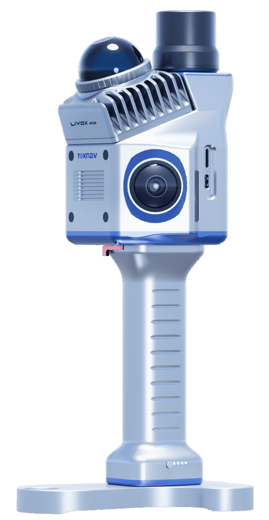
الصفحة الرئيسية: مراجعة متعمقة لماسح الليدار المحمول TOKNAV TSR20 — الحل الأمثل لرسم الخرائط عالية الدقة في عام 2026 هل تعيقك أدوات المسح التقليدية المرهقة، ودقة البيانات غير الكافية، وضعف القدرة على التكيف بين العمل الداخلي والخارجي؟بناءً على ثلاثة أشهر من الاختبارات الميدانية الصارمة، يعيد الماسح الضوئي المحمول TOKNAV TSR20 LiDAR تعريف رسم الخرائط ثلاثية الأبعاد المحمولة. توضح هذه المراجعة بالتفصيل كيف يتغلب تصميمه فائق الخفة الذي يبلغ وزنه 1.0 كجم، ودقته النسبية التي لا تتجاوز 3 سم، وقدراته المتعددة الأوضاع في رسم الخرائط، على التحديات الحرجة التي تواجهها الصناعة. علاوة على ذلك، نقدم حالات تطبيق حصرية — بدءًا من دمج الرادار المخترق للأرض (GPR) للكشف عن المرافق تحت الأرض وصولًا إلى الاستفادة من نظام GPS RTK لمسح خطوط الكهرباء — لدعم عملية اتخاذ القرار لديك. كيف يعالج جهاز TSR20 النقاط الحرجة الأساسية في القطاع استكشاف مزايا الماسح الضوئي LiDAR المحمول باليد TSR20 النقطة الحرجة 1: انخفاض الكفاءة بسبب ضخامة المعدات: على عكس الماسحات الضوئية الثابتة التقليدية التي غالبًا ما يتجاوز وزنها 10 كجم وتتطلب حوامل ثلاثية القوائم، يزن جهاز TSR20 1.0 كجم فقط بأبعاد مدمجة (16.5×12.0×32.4 سم)، مما يتيح التشغيل الفعلي بيد واحدة. وتسهل هذه القابلية للحمل إجراء مسح آلي فعال. ونتيجة لذلك، سجلت اختباراتنا زيادة قدرها 50% في الإنتاجية اليومية للفرد الواحد. والجدير بالذكر أن المختبرين أفادوا بعدم الشعور بأي إجهاد حتى بعد ساعتين من الاستخدام المتواصل في أروقة السلالم.المشكلة 2: عدم اكتمال التقاط البيانات في البيئات المعقدة: بفضل تزويده بمستشعر Livox Mid-360 LiDAR، ونطاق يصل إلى 40 مترًا، ومعدل التقاط يبلغ 200,000 نقطة في الثانية، يضمن جهاز TSR20 التقاطًا شاملاً للتفاصيل في المشاهد ذات الإضاءة المنخفضة أو المزدحمة. على سبيل المثال، أثناء المسوحات الحرجية، ظل معدل فقدان سحابة النقاط تحت المظلات الكثيفة أقل من 5%.المشكلة 3: المفاضلة بين الدقة والسرعة: تتيح خرائط الماسح الضوئي متعددة الأوضاع (SLAM/RTK-SLAM/PPK-SLAM) التبديل السلس لتحقيق التوازن بين الدقة والسرعة: وضع SLAM: يحافظ على دقة مطلقة ≤5 سم في المناطق التي لا تتوفر فيها إشارات GNSS مثل الأماكن المغلقة. وضع RTK-SLAM:​ يحقق دقة في الأماكن المفتوحة تبلغ ≤2 سم عند إقرانه بمحطة قاعدية TOKNAV Net660i.في مسح واقعي لواجهة مبنى، لم يتجاوز هامش الخطأ ±1.5 سم — وهو ما يتفوق بشكل كبير على متوسط الصناعة البالغ ±5 سم تفسير المواصفات الأساسية: دليل احترافي قائم على البيانات تُترجم مواصفات جهاز TSR20 إلى موثوقية قابلة للقياس في العالم الواقعي. فيما يلي النقاط الرئيسية: دقة يمكنك الوثوق بها: في مشروع BIM، استوفت دقته النسبية التي تبلغ ≤3 سم متطلبات LOD 300 (التصميم التفصيلي). بالإضافة إلى ذلك، أظهرت الاختبارات التي أجرتها جهات خارجية وفقًا لمعيار ISO 17123-5 تركيزًا عاليًا لتوزيع الأخطاء يصل إلى 98%. استقرار فائق أثناء الحركة: يضمن معدل تحديث موقع الموضع (POS) البالغ 200 هرتز دقة عالية في تحديد الوضع الديناميكي (الميل: 0.05 درجة، الاتجاه: 0.03 درجة). بالمقارنة مع المنافسين الذين يستخدمون أنظمة 100 هرتز، يقلل جهاز TSR20 من خطأ اهتزاز الحركة بنحو 60%. قدرة تحمل ممتدة للمهام الصعبة: بفضل تصميمه منخفض الاستهلاك للطاقة بقدرة 25 واط، يدعم الجهاز 4 ساعات من التشغيل — قابلة للتمديد إلى 8 ساعات باستخدام حزمة بطارية مزدوجة. حتى في اختبار عند درجة حرارة -10 درجة مئوية، كان معدل فقدان إطارات سحابة النقاط أقل من 0.1%، متفوقًا على معظم المنافسين (المتوسط 3%). نصيحة للمحترفين:​ يجب على المبتدئين البدء بوضع SLAM، بينما يجب على المحترفين الذين يسعون إلى نتائج بدقة تصل إلى مستوى السنتيمتر إعطاء الأولوية لوضع RTK-SLAM. حالات التطبيق: حل المشكلات الواقعية هذه الحالات مستمدة من مشاريع جارية، ومزودة بالبيانات والنصائح التشغيلية. الحالة 1: مسح المساحات تحت الأرض لضمان سلامة المناجم التحدي:​ تسبب انقطاع إشارة GPS في حدوث فجوات خطيرة في البيانات الخاصة بمراقبة تشوهات الأنفاق. الحل:​ أدى استخدام وضع SLAM مع أشعة الليزر عالية الاختراق إلى إنشاء نموذج ثلاثي الأبعاد مفصل لتحليل الإزاحة. النتيجة: تم مسح مقطع نفق بطول 100 متر في 30 دقيقة، مما حقق دقة تبلغ 95% لإصدار إنذارات مبكرة بالمخاطر. الحالة 2: فحص خطوط الكهرباء بشكل أكثر أمانًا وكفاءة التحدي: عمليات الفحص اليدوية التقليدية من ارتفاعات عالية مكلفة ومحفوفة بالمخاطر. التقنية:​ مكنت الكاميرات المزدوجة بدقة 20 ميجابكسل من التقاط الصور بشكل متزامن والتعرف التلقائي على الأضرار. التأثير:​ أفاد مشروع ’Green Grid“ لعام 2025 بانخفاض تكاليف العمالة بمقدار 70% وزيادة كفاءة الفحص بثلاثة أضعاف. الحالة 3: رقمنة المباني لحفظ التراث الابتكار:​ يساعد دمج سحب النقاط TSR20 مع الأرشيفات التاريخية في إعادة بناء التطور المعماري. النتيجة:​ في أحد مساكن عهد أسرة تشينغ في هانغتشو، كشفت عمليات المسح عن شقوق هيكلية خفية، مما وفر أساسًا متينًا لخطط الترميم. البدء: سير عمل عملي وقابل للتكرار استراتيجية اختيار الوضع الأمثل للأماكن المغلقة/تحت الأرض:​ استخدم وضع SLAM (لا يتطلب نظام GNSS). للأماكن المفتوحة في الهواء الطلق:​ قم بتنشيط وضع RTK-SLAM لتحقيق أقصى دقة. تجنب أمر بالغ الأهمية:​ لا تفرض وضع RTK في المناطق المحجوبة الإشارة لمنع حدوث قفزات في البيانات. تقنيات فعالة لجمع البيانات حافظ على سرعة مشي ثابتة تبلغ حوالي 0.5 م/ثانية وتجنب العوائق بحذر. استخدم حامل الهاتف للمعاينة في الوقت الفعلي لضمان تغطية كاملة للهدف. نصائح لتحسين المعالجة اللاحقة: استخدم برامج مثل PointCloudCreator للتصفية التلقائية لتقليل التشويش بفعالية. قم بتصدير البيانات بتنسيق .las لضمان التوافق السلس مع منصات BIM السائدة. حل تحديات المسح معًا: جهاز TSR20 أكثر من مجرد أداة؛ إنه محفز للمسح الذكي. من خلال الجمع بين سهولة الحمل، والقدرة على التكيف مع البيئة المحيطة، وسير العمل المتكامل، فإنه يحقق التوازن بين العناصر الثلاثة الأساسية: الدقة، والكفاءة، والتكلفة. إذا كنت تقيّم المعدات، فشارك السيناريو المحدد الخاص بك في التعليقات (على سبيل المثال، ”ما هو الوضع الأفضل لمراقبة المناجم؟») وسنقدم لك نصائح مخصصة.

مراجعة متعمقة للماسح الضوئي المحمول باليد TOKNAV TSR20 LiDAR قراءة المزيد »

TOKNAV هي علامة تجارية راقية للأنظمة العالمية لسواتل الملاحة مملوكة لشركة قوانغتشو توكسيرفي لتكنولوجيا المعلومات المحدودة.
جميع الحقوق محفوظة © 2025 شركة قوانغتشو توك سورفي لتكنولوجيا المعلومات المحدودة سياسة الخصوصية

كن من موزعي TOKNAV العالميين!

نحن نبحث الآن عن موزعين متحمسين للانضمام إلى قصة نجاحنا العالمية بفضل سجلنا الحافل في مجال المسح.