Hydrographic Survey and USV

Hydrographic survey, echo sounder, USV and unmanned survey boat content for water mapping and positioning projects.

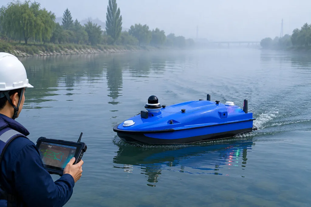
Professional echo sounder working for river surveying and hydrographic survey on field site

Best Echo Sounder for River Surveying: Practical Hydrographic Survey Guide

Home Best Echo Sounder for River Surveying: Practical Hydrographic Survey Guide 2026-06-03 1. Quick Overview: Why Echo Sounders Power River Hydrographic Surveys At Toknav, we know echo sounders are the primary depth-sensing tool in hydrographic surveys, especially for riverbed mapping. In this guide, we break down the latest survey-grade models. We also discuss practical workflows for river surveying. We’ve built a detailed spec comparison table, picked the top 3 echo sounders for river use, and explained how your choice impacts survey accuracy and efficiency. We’ve added clear links and CTAs to help you explore our USV and support services for turnkey solutions. Professional echo sounder working for river surveying and hydrographic survey on field site Hydrographic surveying maps underwater depths, terrain, and hidden obstacles. This ensures navigation safety and supports waterway engineering projects. Rivers and shallow waterways present tricky challenges, including vegetation, turbidity, and shifting depths. That’s why high-frequency 200 kHz echo sounders are our go-to for precise shallow-water detection. Integrated GPS and RTK positioning are also must-haves. They tag every depth reading with accurate geographic coordinates for reliable mapping results. 2. Key Factors to Choose an Echo Sounder for River Surveying Picking a suitable echo sounder makes all the difference for smooth field work. Below are the core factors every river surveyor should check before making a choice. 2.1 Frequency & Signal Penetration High-frequency systems around 200 kHz deliver sharp detail in shallow river water. Lower frequencies (24–33 kHz) cut through murky water but use wider signal beams. Dual-frequency echo sounders combine both strengths, letting you capture clear data no matter if the river is clear or filled with sediment and turbidity. 2.2 Beam Angle Narrow beams (3–5°) capture finer spatial details for precise river mapping. Wider beams (8–20°) cover more ground per ping but reduce detail level. For example, our integrated echo sounder for Tboat USVs uses an 8° beam at 200 kHz, striking a perfect balance between wide coverage and clear survey data for river routes. 2.3 Depth Range Most river surveys only require a 0–100 m depth range. Still, models supporting 200 m or deeper add great flexibility for deep river channels. Our echo sounder covers 0.3–200 m, handling regular shallow rivers and deeper water sections without switching devices. 2.4 Accuracy & Resolution Professional survey-grade echo sounders reach centimeter-level accuracy. Our model offers ±2 cm depth accuracy for highly reliable river data. Most modern devices hit ±0.01 m or 0.1% of measured depth, with 10–20 Hz ping rates boosting data density for fast-flowing river environments. 2.5 Integration & Interface Quality echo sounders support standard NMEA or Ethernet data output, like RS-232 and TCP/IP. This allows for seamless connection with GNSS receivers and survey software. All-in-one portable units that combine echo sounder and GNSS simplify setup. They are perfect for small survey boats working along narrow river sections. Your echo sounder selection directly impacts final bathymetry results. A precise device delivers clear maps, while poor transducer choices can cause data errors or missing terrain features. Get Free Professional Advice | Inquire About Echo Sounder Selection 3. Echo Sounder Spec Comparison for River Surveys We’ve sorted mainstream river survey echo sounders into a clear table below, with specs pulled directly from official product data for your easy reference. Main echo sounder models for river surveying and hydrographic survey specification display Model Frequency Beam Angle Depth Range Accuracy Interface Ideal Use-Case TSBES (Single-beam Echosounder) 200k Hz 8°  0.5m-200m 1cm+0.1%h Lan,RS232(Baudrate9600-230400) For shallow mapping and portable small-boat hydrography. TMBES (Advanced Multibeam Echosounder) 400k Hz 8°  0.2m-150m 2cm+1ppm(RTK)0.6m(SBAS)//1.2m(single point) RS-232 High-resolution 3D mapping in shallow waters; multifunctional surveys from rivers to coastal areas. SDE (Portable Dual Frequency Echo Sounder) 200k Hz & 20k Hz standard 200k Hz: 7°20k Hz: 20° 200k Hz: 0.3m-200m 20k Hz: 0.5m-600m 200 kHz: ±1cm±0.1%D 20 kHz: ±10cm±0.1%D (D is the depth value) 3* RS232, 1* RS485, 1 power supply interface, 1 transducer port and 1 LAN port High frequency for shallow mapping & silt thickness; low frequency for rivers to deep seas. Each model has its own strengths for different river survey scenarios. Check your on-site conditions and working tools to pick the most matched solution for your team. Request Full Datasheets | Get Custom Price Quote 4. Top 3 Recommended Echo Sounders for River Survey Projects After comparing performance, portability and field adaptability, we’ve picked 3 top models tailored for daily river hydrographic survey work. 4.1 TSBES (Single-beam Echosounder) This single-beam sounder is built exclusively for our Tboat USVs, delivering centimeter-level precision for shallow river mapping.Its 8° beam suits narrow river channels well. Built-in GNSS and RTK sync plus noise filters keep data stable even in turbid river water.The plug-and-play design works perfectly with our USVs, cutting down setup time and improving overall safety during long professional survey missions.It stands out for ultra-precise river bathymetry, letting you get detailed underwater terrain with minimal manual operation from your team. 4.2 TMBES (Advanced Multibeam Echosounder) This portable dual-frequency echo sounder comes with built-in data logging, ideal for mobile river survey teams.Running at 400 kHz with a 8° beam, it covers 0.2–150 m depth and maintains ±2cm (±0.1%) accuracy across full ranges.Its compact all-in-one body fits small boats, kayaks and jet skis. Advanced DSP supports 20 Hz ping rate and clear echograms to tell river vegetation apart from real riverbeds.Independent surveyors love this rugged device. It’s easy to deploy, records complete data and connects smoothly with external GPS units for shallow river channel mapping. 4.3 SDE (Portable Dual Frequency Echo Sounder) This dual-channel echo sounder features a wide frequency range from 20 kHz to 200k Hz for flexible field use.Pair it with a 200k Hz transducer for a narrow 20° beam. It supports depths from 0.3m shallow water up to 600m for multi-scene surveys.As a trusted industry workhorse, it reaches 20k Hz ping rate and steady ±0.01 m (±0.1%) accuracy at 200k Hz.Multiple interfaces including RS-232 and Ethernet ensure easy connection with GPS and survey software. It works reliably from narrow rivers to deep waterways.All three models

Best Echo Sounder for River Surveying: Practical Hydrographic Survey Guide Read More »
Southeast Asia USV Distributor Toknav Tboat USV Philippines Client Feedback

Toknav Tboat Series USV: Philippines Client Approved| Southeast Asia Distributor Recruitment

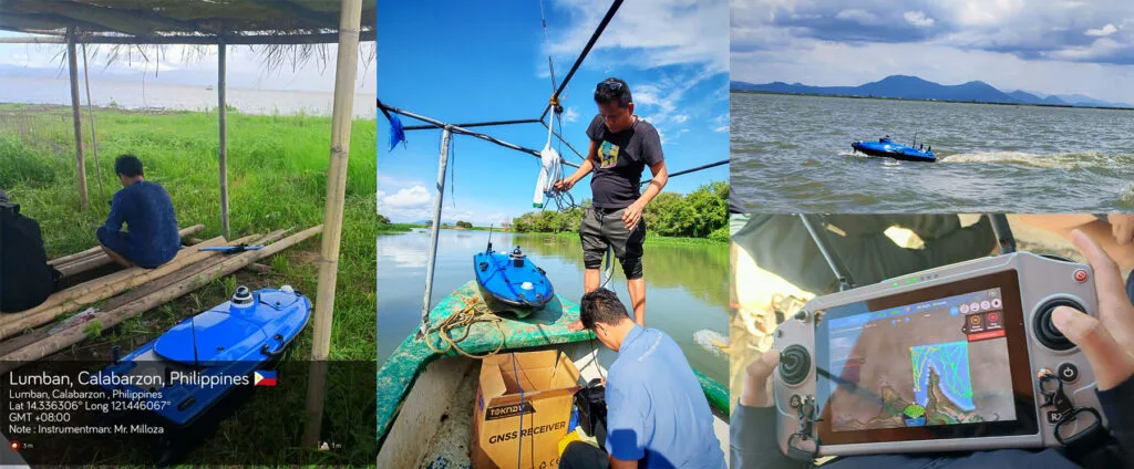
Home Toknav Tboat Series USV: Philippines Client Approved| Southeast Asia Distributor Recruitment 2026-06-03 Why Toknav Tboat USV Leads Southeast Asia Aquatic Survey & Monitoring Southeast Asia has a fast-growing demand for reliable unmanned surface vehicles (USVs) for bathymetry, water quality monitoring, and coastal patrol. Toknav’s Tboat10 and Tboat20 series are tailored to local water conditions, with high automation and strong disturbance resistance. These USVs support full-system RTK positioning and multiple payloads to cover 99% of aquatic operation needs. High-Precision RTK Positioning for Philippine & Southeast Asian Waters Toknav USVs use multi-frequency signal tracking for BDS, GPS, GLONASS, GALILEO, SBAS, and QZSS. The RTK positioning reaches ±8mm horizontal +1ppm and ±15mm vertical +1ppm, ideal for Philippine coastal mapping and river surveying. It ensures stable data collection even in narrow waterways and bridge areas. Rugged Design Adapted to Southeast Asian Coastal & River Conditions Tboat10 uses a double-hull M-type carbon fiber body; Tboat20 adopts a full-curved V-shaped hull. Both have IP67 protection, omnidirectional bumpers, and reinforced bow/keel designs. They resist wind force 3–4 and wave height 2–3, perfect for Southeast Asia’s variable coastal and inland water environments. Tboat10 vs Tboat20: Full-Spec USV Models for Diverse Maritime Tasks Toknav provides two professional USV platforms to match different project scales. Tboat10 is compact and portable for small surveys, while Tboat20 is a heavy-duty model for large-scale, long-duration tasks. Both support hot-swap batteries and one-key control for easy field use. Southeast Asia USV Distributor Toknav Tboat10 Tboat20 USV Parameter Comparison Tboat10 Compact USV: Lightweight & High-Efficiency for Small-Scale Projects Tboat10 has a 980520254mm hull, 7kg hull weight, and 35kg max payload. It runs 3 hours at 2m/s and 7 hours at 1.5m/s per battery set, with a 7m/s top speed. It fits echo sounders, water quality sensors, and 360° night vision cameras for shallow-water survey and sampling in the Philippines. Tboat20 Professional USV: All-In-One Solution for 99% Industry Demands Tboat20 measures 1280580430mm, with 12kg hull weight and 50kg max payload. It carries side-scan sonars, multibeam echo sounders, and ADCP for full-terrain topography and hydrological monitoring. Its 7-hour endurance and 6m/s speed meet large-area coastal and reservoir operations in Southeast Asia. Request USV Distributor Quote Philippines Client Testimonials: Real Visual Feedback & On-Site Performance We have received abundant positive feedback and visual materials from Philippine clients using Tboat USVs. Their reviews confirm the stable performance and high accuracy of our products in local water projects. Southeast Asia USV Distributor Toknav Tboat USV Philippines Client Feedback Philippine bathymetry teams shared photos and videos showing Tboat10’s smooth operation in coastal shallow waters. The RTK positioning delivered consistent depth data with ±1cm +0.1% D accuracy, greatly improving survey efficiency. Clients praised its easy transport and plug-and-use design. Water quality monitoring clients in the Philippines highlighted Tboat20’s reliable sampling and data transmission. The 4G/2.4G communication ensures real-time video and data feedback, even in remote island areas. The obstacle avoidance radar enhances safety in complex water environments. Many Philippine partners noted that Tboat USVs reduce manual risks and cut operational costs by over 40% compared with traditional survey boats. The durable carbon fiber hull requires low maintenance, suiting long-term daily use in Southeast Asia’s humid climate. Client video clips show Tboat USVs completing automatic route planning, breakpoint resume, and one-key return-to-home without manual intervention. These intelligent features make them friendly for new users with limited training. Philippine dealers also recognized the strong market competitiveness of Toknav USVs. The open SDK and expansion platform support customized payload integration, helping local businesses win more government and commercial projects. Partner Benefits: Become a Toknav USV Distributor in Southeast Asia Joining Toknav’s distributor network brings exclusive advantages for Southeast Asia partners. We offer full product training, marketing materials, and after-sales support to help you expand local USV market share. You will get exclusive pricing for Tboat10 and Tboat20 series, plus priority access to product upgrades. Our technical team provides online and on-site training for sales, operation, and maintenance to build your professional service capacity. We share high-intent leads from the Philippines, Indonesia, Malaysia, Thailand, and Vietnam. Co-branded marketing materials, client case studies, and SEO content help you boost local brand exposure and conversion rates. Toknav provides a complete after-sales system, including warranty service, parts supply, and remote troubleshooting. You can focus on sales and client development without worrying about technical support burdens. As a Toknav distributor, you can offer customized USV solutions with RTK, sonar, and water quality modules. This flexibility helps you stand out in Southeast Asia’s growing USV market for survey, environmental protection, and coastal security. Southeast Asia USV Distributor Toknav USV Partner Benefits & Support Get Tboat Series Catalog & Price List How to Join Toknav’s Southeast Asia USV Distributor Network The application process is simple and efficient. We welcome companies with experience in surveying, marine equipment, environmental protection, or engineering to partner with us. First, submit your company profile, business scope, and local market plan via our contact form. Our team will review your application and schedule an online meeting within 3 working days. Next, we provide detailed product training and distributor agreement explanation. You will learn product features, sales points, and market strategies tailored to Southeast Asia and the Philippines. After signing the agreement, you will receive official authorization, marketing resources, and initial inventory support. We help you launch local promotion and convert your first clients quickly. We prioritize long-term cooperation and offer incremental rewards based on sales performance. Top distributors get extra discounts, exclusive regional rights, and joint project opportunities. Contact Toknav for USV Cooperation & Product Details Toknav Tboat series USVs are trusted by Philippine clients for bathymetry, water quality monitoring, and coastal patrol. Their RTK precision, rugged design, and flexible expansion make them the top choice for Southeast Asia aquatic operations. We are actively recruiting dedicated distributors across Southeast Asia to provide reliable USV solutions and capture the booming market demand. Partner with Toknav to share professional products, full support, and stable profit margins. Click to explore our full USV series and submit your distributor inquiry:

Toknav Tboat Series USV: Philippines Client Approved| Southeast Asia Distributor Recruitment Read More »

TOKNAV hydrographic survey equipment in field operation for precise water mapping 

TOKNAV Hydrographic Survey Equipment :7 Ways to Elevate Your Mapping Success

Home TOKNAV Hydrographic Survey Equipment: Professional Solutions for Precise Underwater Mapping 2026-03-16 Introduction: Core Value of Hydrographic Survey & Equipment Hydrographic survey is a vital geospatial discipline focused on mapping underwater features—including water depths, seabed topography, submerged obstacles, shorelines and aquatic environmental data. It serves as the foundational pillar for safe marine navigation, coastal infrastructure building, offshore engineering, environmental monitoring, dredging and marine resource exploration. Without precise hydrographic data, maritime operations face severe risks like vessel grounding, structural damage and inefficiency, making reliable hydrographic survey equipment indispensable for modern waterway and marine projects.Unlike land surveying, hydrographic survey operates in dynamic aquatic environments, demanding rugged, high-precision tools resistant to water exposure, wave interference and variable water conditions. Modern hydrographic survey has evolved from manual labor-intensive work to intelligent automated systems, with core equipment delivering accurate real-time underwater mapping data. This guide breaks down key hydrographic survey gear, details TOKNAV’s Tboat10/Tboat20 USV-integrated solutions, outlines European compliance rules and walks through a full project workflow, all centered on professional-grade, field-ready equipment. TOKNAV hydrographic survey equipment in field operation for precise water mapping  Core Hydrographic Survey Equipment & TOKNAV Applications 1. Marine Survey USV: TOKNAV Tboat10 & Tboat20 Series Unmanned Surface Vehicles (USVs) are game-changing for hydrographic survey, eliminating manned vessel risks and boosting efficiency, flexibility and safety. TOKNAV’s Tboat10 and Tboat20 are purpose-built survey carriers, navigating shallow waters, narrow channels, hazardous coasts and remote areas inaccessible to crewed boats, with rugged builds tailored for professional survey work.The Tboat10 features a lightweight carbon fiber M-hull (7kg hull, 30kg total) with 35kg payload, anti-collision protection and dual hot-swappable batteries, offering 7-hour low-speed endurance, 7m/s max speed and stability in 4m/s cross-currents—ideal for small shallow-water surveys. The Tboat20 uses a durable polyester carbon fiber/Kevlar V-hull (IP67 waterproof, 40kg total) with 50kg payload, 1100W dual motors and matching 7-hour endurance, built for large offshore/coastal projects with stronger wave resistance.Both models support multi-constellation satellite tracking (BDS, GPS, GLONASS, Galileo), radar obstacle avoidance, auto shallow-water reverse and tSail control software for route planning. They cut fuel and labor costs, enabling uninterrupted long missions to collect consistent data for port, river and offshore surveys, making them core hydrographic survey assets. 2. Echo Sounder: High-Precision Depth Measurement The echo sounder is the primary depth-sensing tool in hydrographic survey equipment, using acoustic waves to calculate water depth via seabed reflection. Paired with TOKNAV USVs, it delivers industry-leading precision: 200kHz frequency, 8° beam angle (Tboat10)/5°±1° (Tboat20), 0.15-200m detection range, 8mm depth resolution and ±1cm+0.1%D accuracy. It filters environmental noise, syncs with GNSS coordinates, operates on 9-28V power (5-10W consumption) and works reliably in turbid waters, a non-negotiable kit component. 3. GNSS RTK Receiver: Centimeter-Level Positioning Core Supporting Image 2: Schematic of TOKNAV GNSS RTK receiver, highlighting dual antennas, satellite reception and base station differential links; Image Caption: “TOKNAV GNSS RTK receiver – centimeter-level positioning core for hydrographic survey equipment”GNSS RTK technology delivers centimeter-level positioning, critical for accurate underwater mapping. TOKNAV’s integrated RTK system outperforms standard receivers, correcting satellite and atmospheric errors for stable positioning in complex waters. It boasts RTK accuracy of ±8mm (horizontal)/±15mm (vertical), fast startup <30s, <5s initialization and dual antennas for steady signal reception in sky-obstructed areas. It binds depth data to precise coordinates, supporting compliant high-accuracy hydrographic charting. TOKNAV GNSS RTK receiver – centimeter-level positioning core for hydrographic survey equipment Build a Professional Hydrographic Survey Kit Build a tailored kit by matching gear to project scale and environment: choose Tboat10 for small inland surveys, Tboat20 for large offshore projects. Integrate factory-calibrated echo sounders and RTK receivers for seamless compatibility, add 4G/2.4G communication modules, long-endurance remote batteries and IP67 enclosures for harsh conditions. TOKNAV’s plug-and-play design simplifies deployment, and dedicated software converts raw data into actionable charts and 3D models, eliminating compatibility gaps and boosting efficiency. Complete TOKNAV hydrographic survey equipment kit assembly guide TOKNAV Integrated Hydrographic Survey Solutions TOKNAV integrated hydrographic survey equipment solution for practical water mapping projects TOKNAV provides fully integrated, plug-and-play hydrographic survey solutions, merging USVs, echo sounders and RTK receivers into a unified workflow. Pre-calibrated and pre-configured, the systems cut deployment time and training costs, with intelligent features like one-touch control and hot-swap batteries for nonstop operation. Compliant with global standards and backed by professional support, TOKNAV equipment helps teams deliver high-quality, compliant data efficiently, making it a trusted choice for survey professionals worldwide. European Compliance & Standards European hydrographic projects adhere to strict IHO S-44 bathymetric standards, EU maritime safety rules and environmental directives, requiring centimeter-level positioning, high-resolution measurement and low-impact design. TOKNAV hydrographic survey equipment meets and exceeds these standards: RTK receivers hold certified precision, echo sounders pass rigorous calibration, and Tboat USVs feature IP67 waterproofing, low noise and eco-friendly materials. Full compliance ensures smooth project approval and avoids costly reworks for European surveys. Complete Hydrographic Survey Workflow 1. Pre-Survey Planning: Define project scope, survey area, and accuracy requirements; select TOKNAV hydrographic survey equipment(Tboat10 for small projects, Tboat20 for large-scale); calibrate GNSS RTK and echo sounder; program USV routes via tSail software. 2. Field Deployment & Data Collection: Launch the TOKNAV marine USV, activate autonomous mode; collect real-time depth data via echo sounder and RTK positioning; monitor operations via 360° night vision camera and remote control (1200-nit sunlight-readable display). 3. Data Processing & Validation: Transfer raw data to TOKNAV software; filter noise, correct tide levels, and integrate datasets; validate against IHO S-44 and EU standards to ensurehydrographic survey equipmentdata compliance. 4. Reporting & Deliverables: Generate high-precision hydrographic charts, 3D seabed models, and depth contour maps; compile compliance reports and project documentation for client submission. TOKNAV hydrographic survey project workflow with professional hydrographic survey equipment Conclusion High-performance hydrographic survey equipment is the backbone of precise underwater mapping, and TOKNAV’s integrated USV, echo sounder and RTK solutions set the industry benchmark. With reliable specs, durable builds and EU-compliant design, this gear enhances safety, cuts costs and ensures consistent data collection for all aquatic projects. Upgrade your survey toolkit with TOKNAV’s field-proven solutions—visit our solutions page to explore Tboat series, request a quote or consult

TOKNAV Hydrographic Survey Equipment :7 Ways to Elevate Your Mapping Success Read More »

Powerful Unmanned Survey Boat: 70% Faster Hydrographic Survey with USV

Home Unmanned Survey Boat: Efficient Hydrographic Survey with USV 2026-03-14 Unmanned Survey Boat: Efficient Hydrographic Survey with USV Hydrographic surveying is the core foundation of marine engineering, water conservancy construction, port operation and environmental monitoring, but traditional manual survey methods have long restricted industry efficiency. Manual small vessel surveying exposes staff to extreme weather, rough water and shallow reef risks, with a 30% higher safety hazard rate in complex waters; manual operation efficiency is only 1/4 of unmanned equipment, and labor, vessel maintenance and depreciation costs account for over 60% of the total project budget. Meanwhile, large manual vessels cannot access waters shallower than 0.5m, leaving 20%-35% of key survey areas uncovered. Nowadays, unmanned survey boats have become the optimal replacement for manual methods, and TOKNAV’s hydrographic survey USV relies on high-precision performance and intelligent design, becoming the first choice for efficient marine and inland water survey projects. Core Advantages of Unmanned Survey Boats Compared with manual hydrographic survey, marine USV for survey has four irreplaceable core advantages, solving industry pain points with data-backed efficiency and safety: 1. Zero On-Site Risk, 100% Personnel Safety Unmanned survey boats realize full remote control, keeping surveyors ashore to avoid drowning, capsizing and collision risks. Even in level 5 wind offshore waters or narrow inland tributaries, the USV can complete tasks independently, reducing safety accidents to zero and cutting equipment loss caused by misoperation by 90%. 2. 70% Higher Efficiency, Shortened Project Cycle TOKNAV unmanned survey boats support 6-7 hours of continuous operation at 1.5m/s economical speed, with a maximum speed of 7m/s. Equipped with intelligent route planning, it covers 15km² water areas in 8 hours, completing manual 5-day tasks in 1.5 days, improving overall survey efficiency by over 70% and compressing project cycles effectively. 3. 40% Cost Reduction, Optimized Budget Traditional manual survey needs professional vessels and full-time crews, with annual maintenance costs exceeding $8000. TOKNAV USV features low power consumption and minimal maintenance, eliminating labor costs and reducing vessel depreciation, cutting total survey costs by over 40% for long-term projects without sacrificing data accuracy. 4. Ultra-Shallow Draft, Full-Coverage Survey Manual vessels fail to navigate waters shallower than 0.5m, while TOKNAV Tboat10 has an 8.5cm ultra-shallow draft, Tboat20 a 10cm draft, smoothly accessing shallow lakes, tidal flats and port shallow areas. It realizes 100% full-coverage survey, eliminating blind spots in restricted water environments. High-Precision Positioning: USV + GNSS RTK Working Principle High-precision hydrographic survey relies on centimeter-level positioning, and TOKNAV unmanned survey boat integrates advanced GNSS RTK technology to lock data accuracy. The USV is equipped with dual multi-frequency GNSS antennas, supporting BDS, GPS, GLONASS and GALILEO full-system tracking, with RTK horizontal accuracy of ±8mm +1ppm and vertical accuracy of ±15mm +1ppm. Paired with 0.01m resolution echo sounders, the USV synchronizes positioning and underwater topographic data in real time, collecting 120 sets of data per second. Even in signal-shielded bridge areas, the built-in inertial navigation maintains stable operation, ensuring continuous and reliable data output for high-precision survey reports. TOKNAV Unmanned Survey Boat: Core Technical Features TOKNAV Tboat10 and Tboat20 series hydrographic survey USV are tailored for survey scenarios, with hard-core data to support efficient work: Tboat10 adopts carbon fiber hull with 35kg payload, Tboat20 uses composite hull with 50kg payload and IP67 waterproof rating; dual lithium batteries support hot-swap, 3 hours at 2m/s and 7 hours at 1.5m/s endurance; 0.1-20m radar obstacle avoidance, tSail software supports one-key route planning and homing, realizing easy intelligent operation. Image Caption: TOKNAV USV Core Parameter & Hull Structure Detail Display – Present the close-up of the USV reinforced hull, anti-collision strips and battery compartment, and list key technical parameters in a visual form for quick reading. Wide Applications of TOKNAV Marine USV for Survey TOKNAV unmanned survey boats adapt to diversified survey scenarios, covering core industry demands with practical performance: Dredging Survey: Monitor water depth changes before and after dredging, control error within ±0.02m, ensure construction compliance; Lake & Reservoir Survey: Conduct topographic and sedimentation survey for 10km²+ water areas, support long-term ecological monitoring; Port & Waterway Monitoring: Daily channel patrol, obstacle detection, guarantee 24/7 navigation safety; Underwater Terrain Mapping: Cooperate with sonar equipment to draw high-precision underwater topographic maps for engineering construction. Practical Case: Inland River Hydrographic Survey A water conservancy bureau needed to survey a 15km² inland river with 0.1-0.3m shallow sections. Manual vessels couldn’t access shallow areas, and the 5-day planned cycle was tight. After deploying TOKNAV Tboat10, the 8.5cm draft navigated all waters smoothly; the USV operated continuously for 6 hours, collecting 50000+ valid data sets with centimeter-level accuracy. The project was completed in 1.5 days, with 100% coverage and zero safety risks, providing reliable data for river management. Conclusion & Call to Action Unmanned survey boats have revolutionized hydrographic surveying, replacing manual methods with safety, efficiency and cost advantages. TOKNAV unmanned survey boat series integrates high-precision positioning, intelligent control and strong adaptability, meeting all-round demands of marine and inland water survey. For dredging, lake survey, port monitoring and other projects, TOKNAV USV delivers efficient and accurate survey services. Explore more models: Check Out TOKNAV USV Series TBoat10 Unmanned Surface Vehicle.PDF TBoat20 Unmanned Surface Vehicle.PDF Contact TOKNAV now to upgrade your survey workflow, and enjoy smarter, more precise hydrographic survey solutions! Send an Inquiry

Powerful Unmanned Survey Boat: 70% Faster Hydrographic Survey with USV Read More »

Toknav USVs -Tbaot10

2026 Toknav USVs: Powerful Solutions for Precision Water Operations

Home Toknav Tboat10 & Tboat20 USVs: Smart Tools for Water Operations 2026-02-03 Water tasks like surveying, monitoring, and patrols need reliable gear. Toknav’s Tboat series—Tboat10 and Tboat20—stands out for everyday use. These USVs mix tough builds, easy operation, and smart features. Today, we’ll break down their specs, how they differ, and why they fit real-world water work. 1. Why Choose Toknav USVs for Your Operations? Many USVs are either too complex or not tough enough. Toknav fixes this with Tboat10 and Tboat20. They focus on “no-fuss reliability” for teams that need consistent results. First, both use durable materials that handle rough water. Second, they have simple controls—no pro skills needed. Third, they support hot-swappable batteries to keep work going. Whether you’re measuring water depth (Tboat10) or doing multi-task jobs (Tboat20), these USVs skip the hassle and get the job done. 2. Core Specs: Tboat10 vs. Tboat20 Tboat10 and Tboat20 share Toknav’s practical design but serve different needs. Below is a clear look at their key specs. 2.1 Hull & Build: Tough Yet Easy to UseBoth USVs have strong hulls, but Tboat20 is built for heavier tasks. Tboat10: M-type monohull (carbon fiber); 30kg total weight; 35kg payload. IP67 protection; handles 3rd-level wind and 2nd-level waves. Tboat20: V-shaped hull (polyester fiber + Kevlar); 40kg total weight; 50kg payload. IP67 protection; handles 4th-level wind and 3rd-level waves. Shared Perk: No assembly—unbox and use right away; easy to transport. 2.2 Power & Endurance: Keep Working All Day Battery life matters for long tasks, and both USVs deliver. Tboat10: 33.6V 25Ah dual batteries; 7 hours at 1.5m/s; 7m/s max speed. Hot-swappable without shutdown. Tboat20: 33.6V 25Ah dual batteries; 7 hours at 1.5m/s; 6m/s max speed. Balanced power for longer runs. Shared Perk: Brushless motors (900W for Tboat10, 1100W for Tboat20) with clog-resistant propellers. 2.3 Navigation & Control: Simple Yet PreciseYou don’t need complex training to use these USVs. Satellite Support: Both use BDS, GPS, GLONASS, Galileo—centimeter-level RTK accuracy (±8mm+1ppm). Controllers: 1200-nit sunlight-readable touchscreen; 3km range (unlimited via 4G); 8-hour battery. Shared Perk: tSail software for route planning and real-time data. 2.4 Safety & Expandability: Ready for Any Task Safety features prevent downtime, and expandability fits diverse jobs. Safety: Both have radar obstacle avoidance and shallow-water auto-reverse. Expandability: Tboat10 fits echo sounders, cameras; Tboat20 adds multibeam sonar, ADCP for big tasks. Shared Perk: Open SDK for custom tools (like gas detectors or LiDAR). How to Pick: Tboat10 or Tboat20? Choose based on your daily tasks: Tboat10: Great for small-to-medium jobs—like lake depth measurement or small-area patrols. Its light weight and fast speed (7m/s) work well in tight spaces. Tboat20: Best for heavy tasks—like river hydrological monitoring or coastal surveys. Its 50kg payload handles multiple sensors at once. For water-quality checks, both work: Tboat10 covers small ponds quickly, while Tboat20 takes on large rivers with more tools. Why Teams Love Toknav Tboats Beyond specs, these USVs solve real on-site problems: No Downtime: Hot-swappable batteries mean no stopping to charge. Easy to Learn: Simple controls let new users start in minutes. Tough Enough: IP67 and strong hulls handle rain, waves, and bumps. Grows with You: Add tools as your tasks change—no need for new USVs Conclusion: Tboats for Practical Water Work Toknav Tboat10 and Tboat20 aren’t just USVs—they’re time-savers for teams that need results. Tboat10 keeps small jobs fast and easy; Tboat20 takes on big, complex tasks without hassle.Both skip the over-the-top features and focus on what matters: reliability, ease of use, and long-lasting performance. They fit how you actually work in the field. Quick question: Do you mostly handle small-area surveys or big water projects? Have you ever struggled with USVs that need too much setup? Drop a comment—I’ll help you pick the right Tboat! For more details or a demo, visit www.toknavgnss.com or email info@toknavgnss.com. Follow us for tips on water operation tools!

2026 Toknav USVs: Powerful Solutions for Precision Water Operations Read More »

Become TOKNAV global distributors!

With a proven track record in surveying industry, we’re now looking for passionate distributors to join our global success story.