



TSL150

Integrated HDR Imaging and High-Precision Ranging System

The TSL150 features a lightweight design with a high-precision ranging system and an integrated HDR panoramic imaging system,enabling rapid acquisition of dense 3D point clouds with high-resolution color texture. Equipped with an integrated field processing software,the system supports scanning control,real-time point cloud registration, automatic multi-station adjustment,visual measurement,and point cloud colorization,providing a seam- less end-to-end workflow from data capture to deliverable output. By transferring key office processing tasks directly to the field, TSL150 delivers an accurate and efficient 3D scanning solution for demanding project.

TOKNAV GNSS product visual divider

TSL150

TSL150 terrestrial laser scanner for 3D laser scanning, geospatial data capture and survey mapping projects

TOKNAV TSL150 terrestrial laser scanner is built for 3D laser scanning, geospatial data capture and survey mapping projects. This page now gives buyers a clearer product summary, related TOKNAV links, resource paths and quotation support for distributors, project teams and technical evaluators.

Integrated HDR Imaging and High-Precision Ranging System

The TSL150 features a lightweight design with a high-precision ranging system and an integrated HDR panoramic imaging system,enabling rapid acquisition of dense 3D point clouds with high-resolution color texture. Equipped with an integrated field processing software,the system supports scanning control,real-time point cloud registration, automatic multi-station adjustment,visual measurement,and point cloud colorization,providing a seam- less end-to-end workflow from data capture to deliverable output. By transferring key office processing tasks directly to the field, TSL150 delivers an accurate and efficient 3D scanning solution for demanding project.

System Architecture

TOKNAV TSL150 terrestrial laser scanner for 3D laser scanning, geospatial data capture and survey mapping projects
TOKNAV GNSS product visual divider

Ranging 150m

PRR max. 1.2MHZ

TOKNAV GNSS product visual divider

Accuracy 2mm@50m

Registration On-site

TOKNAV GNSS product visual divider
TOKNAV TSL150 terrestrial laser scanner for 3D laser scanning, geospatial data capture and survey mapping projects

High Precision & Long Range

Max range 150m, 2mm accuracy at 50m, meets high-precision measurement needs.
TOKNAV TSL150 terrestrial laser scanner for 3D laser scanning, geospatial data capture and survey mapping projects

On-Site Intelligent Processing

Real-time point cloud registration, reduces post-processing and ensures data integrity.
TOKNAV TSL150 terrestrial laser scanner for 3D laser scanning, geospatial data capture and survey mapping projects

Efficient Data Acquisition

1.2MHz pulse rate, 100 lines/sec scan speed, captures dense point clouds rapidly.

TOKNAV TSL150 terrestrial laser scanner for 3D laser scanning, geospatial data capture and survey mapping projects

Lightweight & Portable Design

3.3kg compact device, flexible mounting for easy field deployment and operation.

Application Area

TOKNAV TSL150 terrestrial laser scanner for 3D laser scanning, geospatial data capture and survey mapping projects

BIM Modeling Application

TOKNAV TSL150 terrestrial laser scanner for 3D laser scanning, geospatial data capture and survey mapping projects

Pipeline Survey

TOKNAV TSL150 terrestrial laser scanner for 3D laser scanning, geospatial data capture and survey mapping projects

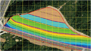
Earthwork Calculation

TOKNAV TSL150 terrestrial laser scanner for 3D laser scanning, geospatial data capture and survey mapping projects

Cultural Heritage Preservation

TOKNAV TSL150 terrestrial laser scanner for 3D laser scanning, geospatial data capture and survey mapping projects

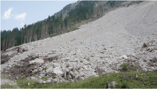
Landslide Site Investigation

TOKNAV TSL150 terrestrial laser scanner for 3D laser scanning, geospatial data capture and survey mapping projects

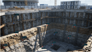
Building & Foundation Deformation Monitoring

TSL150 terrestrial laser scanner buyer checks, links and FAQ

TOKNAV TSL150 terrestrial laser scanner is built for 3D laser scanning, geospatial data capture and survey mapping projects. This page now gives buyers a clearer product summary, related TOKNAV links, resource paths and quotation support for distributors, project teams and technical evaluators.

Selection checks

  • Confirm application, target accuracy, correction method and expected operating environment before selecting this product.
  • Compare related TOKNAV products, datasheets and resource guides to avoid choosing a receiver, antenna, controller or software path in isolation.
  • Send project location, quantity, timeline and required accessories when requesting a quotation so TOKNAV can recommend a complete package.

FAQ

What is TSL150 terrestrial laser scanner used for?

TOKNAV TSL150 terrestrial laser scanner is built for 3D laser scanning, geospatial data capture and survey mapping projects. This page now gives buyers a clearer product summary, related TOKNAV links, resource paths and quotation support for distributors, project teams and technical evaluators.

Which related TOKNAV pages should buyers compare?

Buyers should review the linked category, resource, case study and contact pages to compare specifications, applications and quotation requirements.

What should I send when requesting a quotation?

Send your country, application, target accuracy, correction method, expected quantity, project timeline and required accessories or software.

How does this page support SEO and buyer evaluation?

The page now includes the focus topic terrestrial laser scanner, related internal links, visible FAQ content and structured FAQ data for clearer search and buyer context.

Become TOKNAV global distributors!

With a proven track record in surveying industry, we’re now looking for passionate distributors to join our global success story.