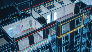
Интегрированная система HDR-изображений и высокоточной дальнометрии
TSL150 имеет легкую конструкцию, высокоточную систему определения дальности и встроенную систему панорамной съемки HDR, позволяющую быстро получать плотные 3D облака точек с цветовой текстурой высокого разрешения. Оснащенная интегрированным программным обеспечением для полевой обработки, система поддерживает управление сканированием, регистрацию облака точек в реальном времени, автоматическую настройку на нескольких станциях, визуальные измерения и колоризацию облака точек, обеспечивая бесшовный сквозной рабочий процесс от сбора данных до получения готовой продукции. Перенося ключевые задачи офисной обработки непосредственно в поле, TSL150 обеспечивает точное и эффективное решение для 3D-сканирования в сложных проектах.
TSL150
Интегрированная система HDR-изображений и высокоточной дальнометрии
TSL150 имеет легкую конструкцию, высокоточную систему определения дальности и встроенную систему панорамной съемки HDR, позволяющую быстро получать плотные 3D облака точек с цветовой текстурой высокого разрешения. Оснащенная интегрированным программным обеспечением для полевой обработки, система поддерживает управление сканированием, регистрацию облака точек в реальном времени, автоматическую настройку на нескольких станциях, визуальные измерения и колоризацию облака точек, обеспечивая бесшовный сквозной рабочий процесс от сбора данных до получения готовой продукции. Перенося ключевые задачи офисной обработки непосредственно в поле, TSL150 обеспечивает точное и эффективное решение для 3D-сканирования в сложных проектах.
Архитектура системы
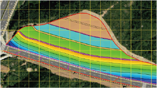
Дальность 150 м
PRR макс. 1,2 МГЦ
Точность 2 мм на расстоянии 50 м
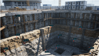
Регистрация на месте
Высокая точность и дальность
Максимальная дальность 150 м, точность 2 мм на расстоянии 50 м, удовлетворяет требованиям высокоточных измерений.
Интеллектуальная обработка на месте
Регистрация облаков точек в режиме реального времени, сокращение объема постобработки и обеспечение целостности данных.