GNSS surveying and mapping software based on years of market experience, it combines the functions of surveying and mapping data acquisition with the functions of RTK control and acquisition, road design and lofting. The software has humanized operation flow, more excellent graphical interaction and more powerful functions.
1. What communication solution is recommended for areas with poor network signals?
Using Radio mode is recommended. Since mobile network signals might be weak in remote rural areas, using a UHF radio is not limited by network coverage. Furthermore, local farms may already have a shared radio base station network available.
2. How can l set up the system to upload agricultural machinery operation data to the Precision Agriculture Platform?
Within the software settings of the auto-steering or guidance system, locate the data upload function (usually requiring a password, e.g., 2022). Correctly enter the server IP address, port number, and other information provided by the platform, and then turn on the “Data Upload” switch.
3. What is the main purpose of the Precision Agriculture Platform?
This platform is used for remote monitoring and management of agricultural machinery. You can view the real-time location, historical operation tracks, worked area, and other information of your machinery, functioning as a centralized equipment information management center.
4. Can the control software be installed and used on any tablet?
No. The software is developed and optimized for specific models of industrial tablets. Hardware resources vary greatly between different tablets, and the software cannot guarantee compatibility and stability on all Android tablets.
5.what causes lagging/stuttering during photogrammetry?
Only run the measuring software on the controller. Other software might consume resources needed for photogrammetry, causing the measurement to crash or lag halfway.
6. Can a camera be added to the TMC20 for remote monitoring of the construction site by office personnel?
A. Check the PDOP limit and height cutoff angle.
B. Ensure the satellite reception environment is good.
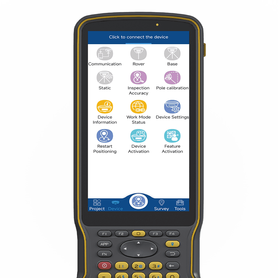
7. When attempting to discover and locate your target device, the Bluetooth signal of the device fails to appear in the search list.
A. Click “Search Bluetooth Devices” again.
B. Ensure that the location information on the device is enabled.
C. Check if the device is turned on.
D. Verify if the Bluetooth name of the device has been changed.
E. Ensure that the device is not too far away from the device.
8. After finding the target device in the Bluetooth list, you are unable to establish a successful connection with it.
A. Re-search for Bluetooth and connect again.
B. Pairing is required for initial connection.
9. When using NFC technology to connect your device to the target Bluetooth device, the pairing and connection process fails to complete.
A. Check if the NFC on the device is working properly.
B. Verify if the NFC tag content matches the actual Bluetooth address of the device.
C. Confirm if the NFC tag is locked.
10. When connecting your device via Bluetooth and checking the handbook for solutions, it displays an invalid or incorrect troubleshooting guide.
A. Check if the surroundings meet the reception conditions.
B. Check if the registration code has expired.
C. Verify if there are any regional restrictions.
D. Ensure that the Bluetooth is connected.
E. Check if the satellite system is turned off
Become TOKNAV global distributors!
With a proven track record in surveying industry, we’re now looking for passionate distributors to join our global success story.