
TOKNAV presenta los receptores GNSS T40 y T40 Pro: Elevando la topografía de precisión con baterías intercambiables y tecnología láser visual
2025-05-06 Receptores GNSS TOKNAV T40 & T40Pro | Batería intercambiable & Visual Laser Surveying
The importance of high precision in surveying cannot be overstated. Professionals in the field require tools that not only meet but exceed current standards of accuracy and reliability. The Toknav T40 and T40Pro GNSS receivers have been developed with feedback from industry experts, ensuring that they meet the needs of modern surveyors.
Actualizaciones clave: Baterías intercambiables para una mayor eficiencia de campo
Visualización láser: Precisión nítida en tiempo real
Moreover, these devices are engineered with user experience in mind, featuring intuitive interfaces and easy-to-navigate menus. Surveyors can spend less time learning how to use the equipment and more time focusing on their actual work. This shift increases overall productivity and satisfaction among users.
T40: Precisión con doble cámara láser y AR
In the realm of geospatial technology, the T40’s laser dual-camera system is particularly noteworthy. This system not only provides accurate measurements but also allows for real-time data visualization, significantly reducing the chances of error during surveying operations. The integration of augmented reality with laser technology is a game-changer, giving users the ability to visualize their measurements directly on-site.
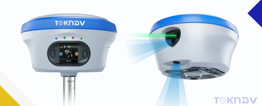
T40Pro: Herramienta de levantamiento fotogramétrico
For the T40Pro, the photogrammetry-ready features enhance its versatility even further. This model is designed to accommodate a wider range of surveying tasks, from traditional land surveying to advanced imaging for construction projects. The ability to capture high-definition images along with precise coordinates allows for comprehensive data collection and analysis.
As surveying technology evolves, so does the necessity for tools that can adapt to various conditions and requirements. The T40Pro, with its enhanced capabilities, empowers professionals to tackle more complex projects efficiently, making it an essential tool for anyone serious about precision in surveying.

Redefinición de la eficiencia topográfica con la serie T40
Additionally, the advancements in the T40 series are not only about technology but also about enhancing workflow. By integrating features such as hot-swappable batteries, users can maintain productivity levels without the interruptions typically associated with battery changes. This is particularly beneficial during extensive fieldwork where time and efficiency are critical.
Más información
Gracias por su interés
Información de contacto
Únase a TOKNAV para dar forma al futuro
In conclusion, the TOKNAV T40 and T40Pro GNSS Receivers represent a significant leap forward in surveying technology. With their combination of innovative features, reliability, and ease of use, they are set to redefine how professionals approach their work. The careful consideration of user feedback in the design process ensures these devices meet the real-world challenges faced by surveyors today.
As we continue to move toward a future where precision and efficiency are paramount, the TOKNAV T40 T40Pro GNSS Receivers stand out as leaders in their field. By investing in these advanced tools, surveyors can enhance their capabilities and remain competitive in an increasingly demanding industry.
For further information regarding the features and applications of the TOKNAV T40 T40Pro GNSS Receivers, potential users are encouraged to research and reach out directly to TOKNAV for personalized consultations and demonstrations.
Ultimately, the investment in the TOKNAV T40 T40Pro GNSS Receivers is not merely a purchase; it is a commitment to excellence, accuracy, and efficiency that will pay dividends in any surveying operation.
No. 9 Caipin Road,Building B, Room 801-6, Huangpu District, Guangzhou, China
Europa | Norteamérica y Sudamérica
Asia | África | Oceanía
+86 139 2607 5986 (Jeffrey)
info@toknavgnss.com
Producto
Soluciones
TOKNAV es una marca GNSS de gama alta propiedad de Guangzhou Toksurvey Information Technology Co.,Ltd.
Derechos de autor © 2025 Guangzhou TokSurvey Information Technology Co.,ltd | Política de privacidad
Conviértase en distribuidor mundial de TOKNAV
Con una trayectoria probada en el sector de la topografía, ahora buscamos distribuidores apasionados que se unan a nuestra historia de éxito mundial.