
Лидарные решения с поддержкой SLAM: Переосмысление захвата 3D-реальности для глобальных проектов
2026-04-18
В современных быстроразвивающихся отраслях, таких как цифровые двойники, интеллектуальная инфраструктура, BIM, промышленная инспекция и сохранение культурного наследия, требуется высокоэффективная, высокоточная и универсально адаптируемая съемка 3D-реальности. Традиционные методы съемки и картографирования в значительной степени зависят от сигналов ГНСС, страдают от низкой эффективности работы в полевых условиях и не могут работать в сложных, стесненных или блокированных сигналами средах. Чтобы решить эти глобальные проблемы, Toknav представляет два профессиональных, проверенных в полевых условиях решения для лидарной съемки с использованием технологии SLAM: ручной лидарный сканер TSR20 и наземный лазерный сканер TSL150. Созданные для международных пользователей, эти интегрированные системы сочетают в себе мобильность, точность и интеллектуальный рабочий процесс, устанавливая новые стандарты для 3D-реконструкции реальных объектов на разных континентах, в разных отраслях и в рамках критически важных проектов.
Лидарные решения на базе SLAM: Ручной сканер Toknav TSR20 в полевых условиях
Основные проблемы глобального захвата 3D-реальности
Проекты по всему миру сталкиваются с тремя постоянными узкими местами:
Среды, в которых не работает GNSS, включая крытые помещения, подземные сооружения, туннели, густые городские каньоны, леса и закрытые пространства, блокируют работу обычных систем позиционирования.
Скорость и точность трудно сбалансировать - мобильным сканерам часто не хватает точности, а статичные наземные сканеры разворачиваются медленно и требуют серьезной постобработки.
Сложные, трудоемкие рабочие процессы удлиняют сроки реализации проектов, повышают операционные риски и увеличивают общие затраты.
Toknav TSR20 и TSL150 решают эти проблемы в тандеме: мобильное SLAM-сканирование для широкого и быстрого охвата и статическое наземное сканирование для получения сверхточных деталей. Вместе они образуют комплексное решение на базе SLAM LiDAR для профессионального 3D-моделирования и доставки пространственных данных.
Ручной SLAM LiDAR сканер TSR20: Мобильность и превосходное картографирование в режиме реального времени
Разработанный для динамичного сбора данных в движении, TSR20 объединяет передовые алгоритмы SLAM с датчиком Livox Mid-360 LiDAR для создания плотных и точных облаков 3D-точек в режиме реального времени - с покрытием GNSS или без него.
Ключевые преимущества
Многорежимные характеристики SLAMПоддерживая режимы SLAM, RTK-SLAM и PPK-SLAM, система объединяет LiDAR, высокочастотный IMU и многоконсольные GNSS, обеспечивая относительную точность ≤3 см и абсолютную точность ≤5 см, полностью удовлетворяя требованиям профессиональных BIM, цифровых двойников и инженерных изысканий.
Неограниченные возможности адаптации к окружающей среде Благодаря неповторяющемуся сканированию на 360°, дальности измерения 40 м и сильному точечному проникновению TSR20 надежно работает в подземных пространствах, внутренних помещениях, на лестничных клетках, парковках, в коридорах линий электропередач и низкоствольных лесах.
Сверхлегкий и эргономичныйСканер весом всего 1,0 кг и компактным форм-фактором позволяет одному пользователю комфортно работать с ним в течение всего дня. Прочная конструкция и низкое энергопотребление обеспечивают стабильную работу в суровых полевых условиях.
Настоящая цветная 3D-реальностьДве сверхширокоугольные камеры 20 Мп с полем зрения 200° синхронизируют данные изображения, создавая фотореалистичные, текстурированные 3D-модели с четкими геометрическими и визуальными деталями.
Единый рабочий процесс64 ГБ встроенной памяти и SD-карта с возможностью расширения до 128 ГБ, беспроводная передача данных по WiFi и специальное программное обеспечение для постобработки обеспечивают беспрепятственное получение, визуализацию, классификацию, фильтрацию и моделирование в едином конвейере.
Идеальное применение
Картографирование подземного пространства, 3D-реконструкция помещений, обследование зданий, обследование линий электропередач, картографирование лесного хозяйства, картографирование при ликвидации последствий чрезвычайных ситуаций, а также проекты мобильной съемки больших площадей.
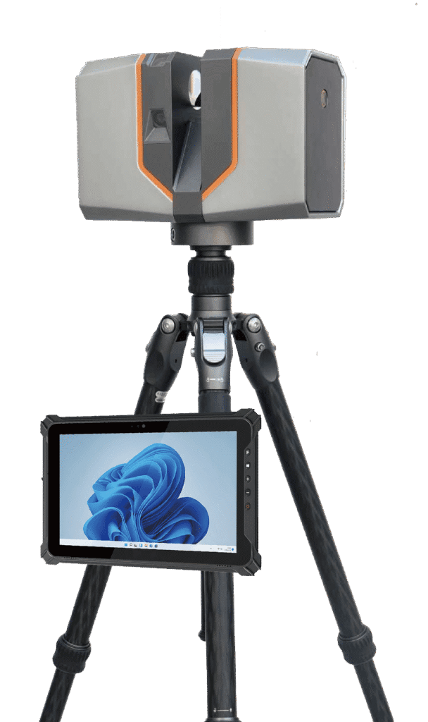
Наземный лазерный сканер TSL150: Статическое сканирование с миллиметровой точностью
Разработанный для высокоточных статических измерений, TSL150 сочетает в себе дальнюю лазерную дальность, профессиональное HDR-изображение и встроенную интеллектуальную обработку для получения результатов съемки для сложных инженерных и документационных задач.
Ключевые преимущества
Точность миллиметрового уровняПри максимальном радиусе действия 150 м система достигает точности 2 мм@50 м и 3 мм@100 м, что делает ее идеальной для структурного мониторинга, оцифровки наследия, точного реверсивного проектирования BIM и промышленной метрологии.
Высокоскоростной захват данныхЧастота следования импульсов 1,2 МГц и скорость сканирования 100 линий/сек значительно сокращают время работы в полевых условиях при создании плотных и высококачественных облаков точек.
Интеллектуальная обработка на месте Встроенное программное обеспечение поддерживает регистрацию облака точек в режиме реального времени, автоматическую настройку нескольких станций и визуальные измерения, сводя к минимуму постобработку в офисе и обеспечивая целостность данных до выезда на место.
Компактность и гибкость развертыванияВесом всего 3,3 кг и небольшой площадью, TSL150 поддерживает как вертикальный, так и перевернутый монтаж для использования в ограниченном пространстве, на возвышенностях и в труднодоступных местах. Степень защиты IP54 обеспечивает долговечность в сложных условиях.
Слияние нескольких датчиковПанорамная камера HDR с разрешением 100 Мп, MEMS IMU и поддержка нескольких ГНСС обеспечивают точную привязку к местности и насыщенные цветом облака точек, готовые для профессионального картографирования и моделирования.
Решения LiDAR с поддержкой SLAM: Наземный лазерный сканер Toknav TSL150
Идеальное применение
Сохранение культурного наследия, мониторинг деформации зданий, высокоточное BIM-моделирование, съемка трубопроводов, расчет земляных работ, исследование оползней и измерение промышленных объектов.
Превосходная комбинация: TSR20 + TSL150
Для глобальных проектов по захвату 3D-реальности ручной SLAM-сканер TSR20 и наземный сканер TSL150 прекрасно дополняют друг друга:
TSR20 быстро охватывает большие, сложные или труднодоступные участки с помощью эффективного мобильного сканирования.
TSL150 обеспечивает детализацию на уровне миллиметра для критических структур, ключевых компонентов и высокоточной документации.
В совокупности они обеспечивают полномасштабное и высокоточное 3D-моделирование со значительным сокращением времени, трудозатрат и стоимости.
Эта мощная пара поддерживает проекты цифрового строительства, интеллектуальной инфраструктуры, цифровой трансформации промышленности и сохранения наследия по всему миру.
Решения для LiDAR с поддержкой SLAM: Комбинированный рабочий процесс TSR20 и TSL150
Почему стоит выбрать Toknav?
Профессиональные алгоритмы SLAM и слияния датчиков обеспечивают стабильную и высокоточную работу в различных условиях.
Глобальная конструкция поддерживает совместимость с несколькими ГНСС и надежно работает в различных климатических и полевых условиях.
Сплошной рабочий процесс объединяет получение, обработку и моделирование для снижения сложности и повышения эффективности.
Прочное, портативное оборудование создано для ежедневного профессионального использования в международных полевых проектах.
Глобальная поддержка клиентов обеспечивает плавное развертывание, обучение и долгосрочную надежность.
Изучите решения Toknav для захвата 3D-реальности
Узнайте, как TSR20 и TSL150 могут повысить точность, скорость и эффективность ваших проектов.Ключевые слова для поиска: Toknav TSR20, Toknav TSL150, портативный SLAM LiDAR, наземный лазерный сканер, захват 3D реальности, система SLAM сканирования.
Toknav предоставляет профессиональные, надежные и перспективные решения SLAM LiDAR для превращения физических пространств в точные и пригодные для использования цифровые активы.