
Hydrographic Survey Equipment
Best Echo Sounder for River Surveying: How to Choose for Shallow, Muddy and USV Workflows
For river surveying teams, the best echo sounder is not only the sensor with the right depth range. It must work with the water condition, GNSS positioning workflow, survey software, boat or USV platform and the final deliverable required by the project owner.
Author: TOKNAV GNSS Solution Team. Last updated: July 2026.
Use this guide when you need to compare echo sounders, GNSS positioning and survey platforms for real river conditions. It is written for survey teams, contractors, distributors and project owners who need a practical equipment path rather than a generic sensor list.
Download the Hydrographic Survey PDF Checklist
Get a printable checklist for river condition, depth range, platform choice, GNSS correction workflow, echo sounder requirements and quote preparation.
Start With the Survey Job, Not the Sensor Name
A buyer searching for the best echo sounder for river surveying usually has a practical question: what equipment will produce reliable depth data in a real river environment? The answer depends on the project, not only on the echo sounder model.
Before comparing hardware, define whether the work is a simple river cross-section survey, reservoir mapping, bridge construction support, dredging check, flood-control inspection, shallow-water mapping or a USV-based unmanned survey. Each use case changes the importance of depth range, transducer installation, GNSS position quality and data output.
Water condition
Shallow, muddy or vegetation-heavy rivers may require more careful sensor selection, transducer mounting and survey speed control than open deep water.
Positioning workflow
Depth points need reliable horizontal positioning. RTK GNSS, base station, network correction or integrated USV positioning should be planned together.
Platform choice
Manual boat work, portable kits and USV workflows have different power, mounting, communication and safety requirements.
How to Choose for Shallow, Muddy River Water
Shallow and muddy rivers are common in practical hydrographic work. The project team may face low water depth, suspended sediment, unstable banks, debris, vegetation, narrow channels and difficult boat access. In this environment, the best hydrographic echo sounder setup is the one that maintains usable data while reducing field risk.
| Selection factor | What to check | Why it matters |
|---|---|---|
| Minimum and maximum depth | Confirm the shallowest expected depth and deepest channel section. | A mismatch can cause missing data, weak readings or unnecessary equipment cost. |
| Bottom condition | Describe mud, sand, rock, vegetation or mixed bottom type. | Bottom condition affects signal return and data interpretation. |
| GNSS correction | Confirm RTK base, network RTK, CORS/VRS or onboard GNSS workflow. | Depth data is only useful when position and time synchronization are reliable. |
| Mounting method | Define pole, boat side mount, hull mount or USV integration. | Mounting affects draft, stability, calibration and data repeatability. |
| Survey platform | Choose manual boat, compact portable system or USV. | Rivers with safety or access risk often benefit from unmanned surface vehicle workflows. |
When a USV Workflow Is Better Than a Manual Boat
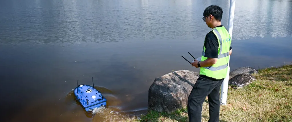
A manual boat can be practical for many river surveys, but a USV can be a better fit when the site is narrow, dangerous, difficult to access, repetitive or not suitable for crewed operation. For these projects, the echo sounder, GNSS receiver, communication link and mission workflow must be selected as one system.
TOKNAV can support buyers who are comparing a portable hydrographic kit, USV survey workflow or a broader hydrographic survey equipment package. The inquiry should include river width, depth range, current condition, required deliverable, GNSS correction method and whether the buyer needs a manual or unmanned platform.
Continue Planning With TOKNAV Resources
For equipment comparison
For positioning and project design
What to Send Before Requesting a Hydrographic Quote
A good inquiry gives the technical team enough context to recommend the right equipment path. Send these details when asking for a hydrographic package recommendation:
- River or water body type, approximate width and depth range.
- Water condition: muddy, shallow, fast current, vegetation, debris or clear water.
- Survey objective: cross sections, bathymetric map, dredging check, bridge support, reservoir or flood-control project.
- Preferred platform: manual boat, portable kit or USV.
- Positioning requirement: RTK base, network RTK, CORS/VRS or other correction method.
- Expected output: raw depth points, profile, CAD/GIS deliverable, map or inspection report.
الأسئلة الشائعة
What is the best echo sounder for shallow river surveying?
The best option depends on depth range, bottom condition, survey platform and GNSS workflow. For shallow muddy rivers, send water conditions and platform requirements before selecting equipment.
Do I need RTK GNSS for hydrographic surveying?
RTK GNSS is often important when the project requires accurate georeferenced depth data. The positioning workflow should be planned together with the echo sounder and platform.
When should I choose a USV for river surveying?
Consider a USV when the site is unsafe, narrow, repetitive, hard to access or better suited to unmanned operation.
Can TOKNAV recommend a complete package?
Yes. Share the survey objective, depth range, river condition, platform preference and positioning requirement so TOKNAV can recommend a package.
Need a Hydrographic Survey Equipment Recommendation?
Send the river condition, depth range, survey objective and platform preference. TOKNAV can help compare echo sounder, GNSS positioning and USV workflow options.