
شرح نظام GNSS RTK: إعداد القاعدة والمركبة لنجاح المسح
2026-03-12
إن نظام GNSS RTK الكامل هو العمود الفقري للمسح عالي الدقة، مما يمكّن المساحين من تحقيق دقة على مستوى السنتيمتر في الوقت الفعلي. ولكن ما هو بالضبط نظام GNSS RTK، وكيف يمكنك إعداد مكوناته الأساسية - المحطة الأساسية والمركبة الجوالة - لضمان نجاح المسح؟ تقدم TOKNAV، بصفتها موردًا رائدًا لأنظمة GNSS، نظام GNSS RTK شاملًا لنظام GNSS RTK، بما في ذلك مجموعة أدوات المسح الأساسية عالية الجودة لنظام GNSS، المصممة لتبسيط الإعداد وتقديم نتائج موثوقة لمحترفي المسح.
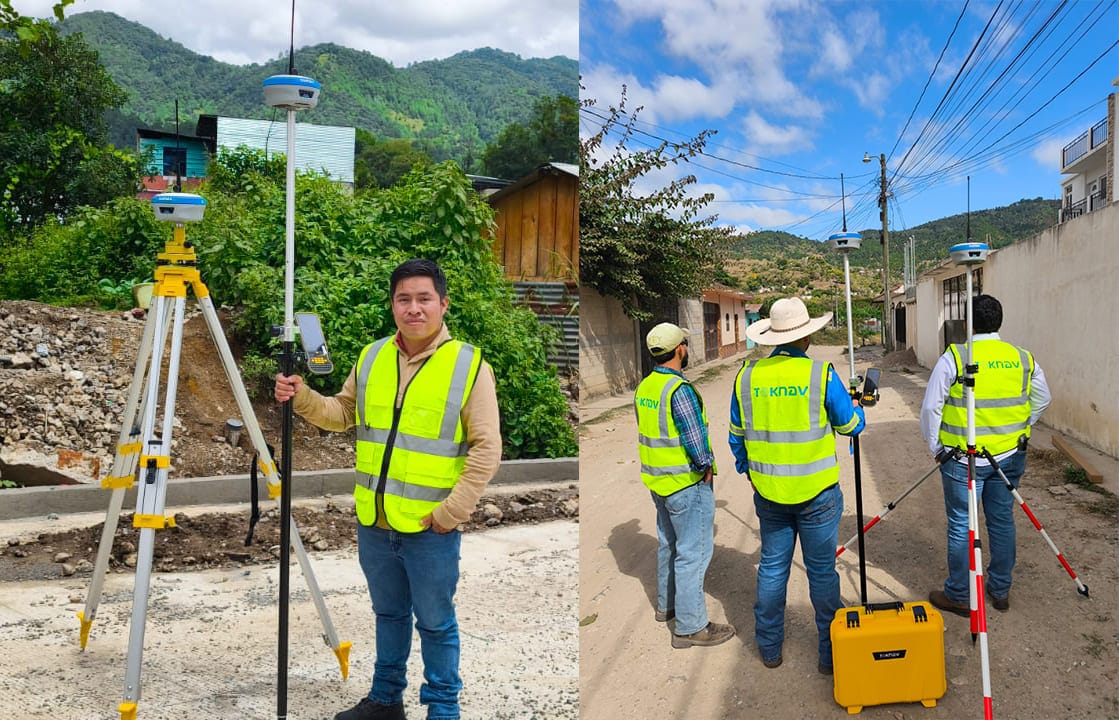
تبسّط مجموعة أدوات المسح المتجول الأساسي GNSS من TOKNAV عملية المسح عالية الدقة لمحترفي المسح.
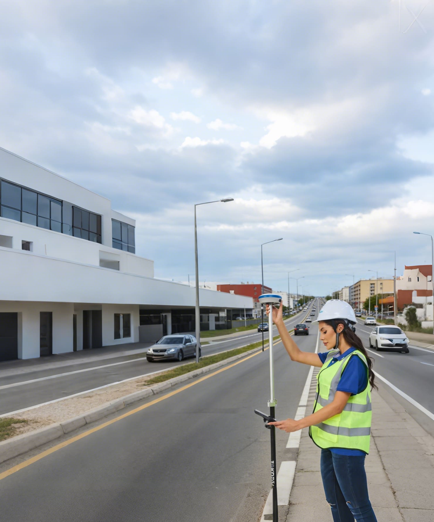
لنبدأ بالأساسيات: ما هي مكونات نظام GNSS RTK الكامل؟ يتكون نظام GNSS RTK النموذجي من ثلاثة أجزاء رئيسية: محطة قاعدية وجوالة (جهاز استقبال GNSS RTK) ووصلة اتصال بينهما. والمحطة الأساسية هي عبارة عن جهاز استقبال ثابت خاص بالنظم العالمية لسواتل الملاحة مثبت في موقع معروف، بينما العربة الجوالة هي جهاز استقبال محمول خاص بالنظم العالمية لسواتل الملاحة يستخدم لجمع البيانات في الميدان. وينقل رابط الاتصال - عادةً ما يكون UHF أو 4G أو NTRIP - بيانات التصحيح من المحطة الأساسية إلى العربة المتجولة، مما يسمح للعربة المتجولة بضبط قراءات الأقمار الصناعية وتقديم تحديد دقيق للمواقع.
يعد فهم أدوار المحطة الأساسية والمركبة الجوالة أمرًا بالغ الأهمية لنجاح المسح باستخدام تقنية تحديد الموقع بالترددات الراديوية. ويتمثل الدور الأساسي للمحطة الأساسية في العمل كنقطة مرجعية. فهي تستقبل باستمرار إشارات من الأقمار الصناعية للنظم العالمية لسواتل الملاحة وتحسب موقعها الخاص. ونظراً لأن موقع المحطة الأساسية معروف (إما من نقطة تم مسحها مسبقاً أو من إحداثيات الشبكة الوطنية)، يتم اكتشاف أي أخطاء في إشارات الأقمار الصناعية وتحويلها إلى بيانات تصحيح. ثم يتم إرسال بيانات التصحيح هذه إلى العربة الجوالة في الوقت الحقيقي. وتستخدم العربة المتجولة، التي تتحرك حول منطقة المسح، بيانات التصحيح هذه لإزالة الأخطاء في قراءات الأقمار الصناعية الخاصة بها، مما يؤدي إلى دقة على مستوى السنتيمتر.
دراسة حالة واقعية: كيف فازت القاعدة السليمة وإعداد الروفر بمشروع مسح الطرق في جنوب فرنسا
في العام الماضي، واجه فريق المسح في جنوب فرنسا موعداً نهائياً ضيقاً لمشروع إعادة مسح طريق ريفي بطول 12 كم. كانت التضاريس عبارة عن مزيج من الأراضي الزراعية المفتوحة والأجزاء المكسوة بالأشجار، مع تغطية خلوية متقطعة. في البداية، استخدموا في البداية جهاز استقبال GNSS أساسي بدون نظام تحديد المواقع العالمي لتحديد المواقع (RTK) وعانوا من أخطاء على مستوى المتر، مما أجبرهم على إعادة القياس بشكل متكرر - مما أدى إلى إضاعة الوقت وتعريض الجدول الزمني للخطر.
بعد التبديل إلى مجموعة أدوات النظام العالمي لسواتل الملاحة (TOKNAV)، اتبعوا أفضل الممارسات لإعداد محطة قاعدية ثابتة على نقطة تحكم معتمدة مع رؤية السماء دون عائق (وهو أمر بالغ الأهمية لدقة الإشارة). استخدموا التردد فوق العالي UHF للمسافات القصيرة المدى (حيث كانت الإشارة الخلوية ضعيفة) والجيل الرابع 4G الاحتياطي للمسافات الأطول عبر الأراضي الزراعية المفتوحة. في غضون ساعات، حقق الفريق دقة متسقة على مستوى السنتيمتر، حتى بالقرب من خطوط الأشجار - مما أدى إلى الاستغناء عن إعادة العمل بالكامل.
والنتيجة؟ لقد أنهوا المشروع الذي يبلغ طوله 12 كم قبل يومين من الموعد المحدد، ووفروا تكاليف العمالة، وحصلوا على عقد متابعة لمسوحات صيانة الطرق القريبة. يثبت هذا المثال الواقعي: إن الإعداد الصحيح للقاعدة والمركبة الجوالة يحول الدقة النظرية إلى نجاح ميداني قابل للقياس - حتى في التضاريس الصعبة.
قدم نظام GNSS RTK الخاص بشركة TOKNAV دقة على مستوى السنتيمتر لمسح طريق ريفي بطول 12 كم في فرنسا، متجاوزًا الموعد النهائي بيومين.
دليل خطوة بخطوة لإعداد طقم أدوات روفر قاعدة TOKNAV GNSS الخاص بك
قد تبدو عملية إعداد مجموعة أدوات النظام العالمي لتحديد المواقع (GNSS) المتجول الأساسي عملية شاقة، ولكن مع التوجيه الصحيح، فهي عملية مباشرة. اتبع هذه الخطوات لضمان الدقة والكفاءة في المسح التالي:
اختر موقعاً مناسباً للمحطة الأساسية: اختر منطقة مفتوحة خالية من العوائق (الأشجار والمباني وخطوط الطاقة) التي يمكن أن تحجب إشارات القمر الصناعي. اختر سطحاً مستوياً وثابتاً للحفاظ على ثبات المحطة القاعدية - وهذا يمنع الانحراف الموضعي الذي يمكن أن يفسد الدقة.
قم بإعداد المحطة الأساسية: قم بتركيب هوائي المحطة الأساسية على حامل ثلاثي القوائم عالي الجودة، مع التأكد من أنه مستوٍ ومثبت بإحكام. قم بتوصيل الهوائي بجهاز استقبال المحطة الأساسية، ثم قم بتشغيل الجهاز واتركه للتهيئة (عادةً من 2-5 دقائق).
تكوين المحطة الأساسية: أدخل الإحداثيات المعروفة لموقعك الأساسي (من نقاط التحكم التي تم مسحها مسبقاً أو بيانات الشبكة الوطنية). حدد طريقة الاتصال الخاصة بك (UHF أو 4G أو NTRIP) واضبط تردد الإرسال - اتبع الإعدادات الافتراضية ل TOKNAV للحصول على الأداء الأمثل.
قم بإعداد المركبة الجوالة: قم بتشغيل جهاز استقبال TOKNAV RTK (المركبة الجوالة) وقم بتوصيله بنفس وصلة الاتصال مثل المحطة الأساسية. تأكد من ضبط العربة الجوالة على استقبال بيانات التصحيح - معظم مركبات TOKNAV الجوالة تكتشف ذلك تلقائيًا، مما يسهل عملية الإعداد.
المعايرة والاختبار: بمجرد التوصيل، قم بمعايرة النظام عن طريق جمع البيانات من نقطة تحكم معروفة. اختبر الدقة عن طريق مسح منطقة صغيرة مألوفة والتحقق من النتائج - وهذا يضمن عدم وجود أخطاء في الإعداد قبل بدء مشروعك.

اتبع إعداد TOKNAV البسيط المكون من 5 خطوات لمجموعة أدوات الشبكة العالمية لسواتل الملاحة الأساسية لتحقيق دقة على مستوى السنتيمتر.
خيارات الاتصال الرئيسية لأنظمة GNSS RTK
تعد خيارات الاتصال جزءًا مهمًا من أي نظام GNSS RTK - يعتمد اختيار الخيار المناسب على نطاق المسح وموقعك:
UHF: مثالي للمسوحات قصيرة المدى (حتى 10 كم). إنه موثوق، ولا يتطلب اتصالاً بالإنترنت، ويعمل بشكل جيد في المناطق النائية ذات التغطية الخلوية الضعيفة - وهو مثالي للمسوحات الريفية الأوروبية.
4G: الأفضل للمسوحات بعيدة المدى. يسمح للمحطات الأساسية والمركبات الجوالة بالاتصال عبر مسافات كبيرة (حتى في المناطق النائية) ويقترن بشكل جيد مع مركبات TOKNAV الجوالة لنقل بيانات التصحيح بسلاسة.
NTRIP: يستخدم الإنترنت لنقل بيانات التصحيح، وهو مثالي للمساحين الذين يستخدمون شبكات RTK الوطنية (الشائعة في أوروبا) بدلاً من إنشاء محطة قاعدية خاصة بهم. أنظمة TOKNAV متوافقة تمامًا مع شبكات NTRIP الأوروبية.
أفضل ممارسات إعداد GNSS RTK الخاصة ب TOKNAV
لزيادة الدقة وتقليل وقت التعطل إلى الحد الأقصى، اتبع أفضل الممارسات الموصى بها من TOKNAV:
استخدم حامل ثلاثي القوائم وحامل هوائي عالي الجودة للحفاظ على ثبات المحطة الأساسية - يمكن أن تتسبب الحوامل الرخيصة في انحراف الموضع.
تجنب التداخل متعدد المسارات: اختر مواقع المحطات الأساسية الخالية من الأسطح العاكسة (المباني والمياه والهياكل المعدنية) التي يمكن أن تشوه إشارات الأقمار الصناعية.
المعايرة بانتظام: قم بمعايرة النظام قبل كل مشروع وبعد أي تغيير في موضع الهوائي للحفاظ على دقة على مستوى السنتيمتر.
طابق الاتصالات مع منطقتك: استخدم التردد فوق العالي UHF للنطاقات القصيرة، و4G/NTRIP للنطاقات الأطول - تعمل طرق المزج (مثل التردد فوق العالي UHF مع 4G الاحتياطية) بشكل جيد للتضاريس المتغيرة.
الاستعداد للظروف الميدانية: احتفظ ببطاريات احتياطية وشاحن محمول في متناول اليد لتجنب التوقف عن العمل - وهو أمر بالغ الأهمية لأيام المسح الطويلة في المناطق النائية.
استكشاف مشكلات نظام GNSS RTK الشائعة وإصلاحها
يمكنك تقليل وقت التعطل إلى أدنى حد ممكن من خلال الإصلاحات السريعة لهذه المشكلات الشائعة:
ضعف استقبال الإشارة: تحقق من وجود عوائق (أشجار، مبانٍ) حول المحطة الأساسية/المركبة. قم بتغيير موضع الهوائي إلى نقطة أعلى أو منطقة أوضح - حتى العوائق الصغيرة يمكن أن تقلل من الدقة.
أخطاء الاتصال: تحقق من أن وصلة الاتصال (UHF/4G/NTRIP) نشطة. تحقق من الإعدادات على كل من القاعدة والمركبة الجوالة للتأكد من أنهما يستخدمان نفس التردد/البروتوكول.
بيانات غير دقيقة: قم بإعادة معايرة النظام وتأكد من ضبط المحطة الأساسية على الإحداثيات الصحيحة المعروفة - الإحداثيات غير الصحيحة هي سبب شائع للأخطاء.
مشاكل في البطارية: استبدال البطاريات أو استخدام شاحن محمول. تتمتع مركبات TOKNAV الجوالة بعمر بطارية طويل، ولكن البطاريات الاحتياطية هي دائماً احتياطية آمنة للاستطلاعات طوال اليوم.
يوفر فريق دعم TOKNAV إرشادات خطوة بخطوة لاستكشاف مشكلات نظام GNSS RTK وإصلاحها.
الخاتمة
يعد نظام GNSS RTK جيد الإعداد لنظام GNSS RTK غير قابل للتفاوض لإجراء مسح عالي الدقة. من خلال فهم مكونات النظام وأدوار المحطة الأساسية والمركبة الجوالة واتباع أفضل الممارسات للإعداد واستكشاف الأخطاء وإصلاحها، يمكنك ضمان نجاح المسح - توفير الوقت وتقليل إعادة العمل وتقديم نتائج موثوقة.
صُمم نظام GNSS RTK من TOKNAV ومجموعة أدوات المسح الأساسية GNSS المتجولة خصيصًا لمحترفي المسح الأوروبيين، مع إعداد مبسط وخيارات اتصال متوافقة وأجهزة متينة ومختبرة ميدانيًا. سواءً كنت تقوم بمسح الطرق الريفية أو مواقع البناء أو قطع الأراضي، فإن حلول TOKNAV توفر لك الدقة التي تحتاجها على مستوى السنتيمتر.
هل أنت مستعد للبدء؟
تفضل بزيارة صفحة طقم أدوات المركبة الأساسية الخاصة بنا لمعرفة المزيد عن حل TOKNAV، أو اتصل بفريق الدعم لدينا للحصول على إرشادات خطوة بخطوة مصممة خصيصًا لمشروعك. لا تنسَ استكشاف صفحة نظام GNSS RTK الخاص بنا لمزيد من المعلومات عن حلولنا الكاملة الصديقة لأوروبا.
قم بزيارة صفحتنا
استكشف مجموعة أدوات نظام الملاحة المتجول الأساسي GNSS من TOKNAV وابدأ المسح عالي الدقة اليوم.