
Le pic de construction d'avril : Le système de guidage TokNav TMC10 pour les bulldozers : un gain d'efficacité
2026-04-16
Avec l'arrivée du mois d'avril, les températures grimpent régulièrement, ouvrant la voie à un boom de la construction à l'échelle nationale. Qu'il s'agisse de projets d'infrastructure à grande échelle, comme les autoroutes et les chemins de fer, de bâtiments urbains ou d'améliorations de routes rurales, la plupart des projets d'ingénierie lancent des travaux de construction à grande échelle pendant cette période de pointe. Pour les équipes de construction, cette saison chargée s'accompagne de calendriers serrés et de normes de qualité strictes, ce qui rend les opérations efficaces et précises non négociables. Au premier plan de chaque projet réussi se trouvent deux piliers essentiels : des levés techniques professionnels et un contrôle mécanique fiable, qui jettent les bases d'une progression sans heurts et d'une livraison dans les délais.
L'épine dorsale de la construction : Le levé d'ingénieur et les difficultés liées aux méthodes traditionnelles
La cartographie technique et l'arpentage de construction constituent l'épine dorsale de l'ensemble du processus de construction. Les tâches telles que l'implantation du site, le contrôle des pentes et le nivellement du sol exigent une précision extrême afin d'éviter des travaux de reprise coûteux et le gaspillage de matériaux. Même des écarts de mesure mineurs peuvent entraîner des problèmes majeurs : surfaces inégales, pentes incorrectes ou erreurs structurelles qui compromettent la sécurité. Malheureusement, les méthodes de construction traditionnelles encore largement utilisées dans l'industrie peinent à suivre le rythme des exigences modernes, ce qui crée des goulets d'étranglement au niveau de la productivité.
Limites de l'utilisation d'un bouteur conventionnel pour les levés de construction et la cartographie technique
Le fonctionnement des bouteurs conventionnels repose en grande partie sur l'arpentage manuel, le marquage et l'expérience de l'opérateur. Les géomètres passent des heures à planter des piquets et à mesurer des pentes, ce qui entraîne un gaspillage de main-d'œuvre et expose les travailleurs à des risques de sécurité. Ce processus est lent, exigeant en main-d'œuvre et sujet à l'erreur humaine - les conditions météorologiques, les problèmes de visibilité ou les erreurs de calcul sont autant de facteurs qui entraînent des écarts de précision. Les opérateurs doivent constamment se référer à des repères manuels, ce qui entraîne souvent un creusement inégal ou des travaux de reprise. Pour les projets de grande envergure, ces inefficacités s'additionnent rapidement : délais prolongés, coûts gonflés et qualité compromise, ce qui ne permet pas de répondre aux demandes de volume et de précision élevés pendant la période de pointe de la construction.
Le système de guidage TokNav TMC10 pour les bulldozers : La solution aux défis de la construction de haute précision
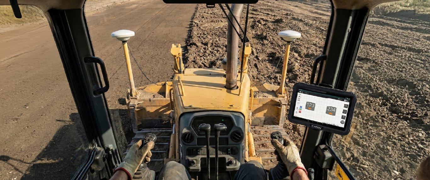
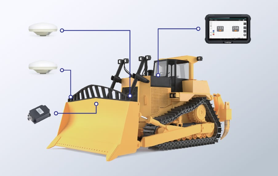
Pour résoudre ces problèmes, TokNav GNSS a lancé le système de guidage TokNav TMC10 Dozer, une solution 3D intelligente de pointe conçue pour les bulldozers. Conçu pour la précision et la convivialité, ce système intègre un positionnement par satellite GNSS haute performance et des capteurs de mesure inertielle IMU, s'affranchissant ainsi des limitations manuelles. Il fournit en temps réel des données de positionnement au centimètre près, transformant ainsi des bulldozers ordinaires en machines intelligentes et précises qui améliorent le travail sur site.
Le principal avantage du TokNav TMC10 est sa précision de positionnement de 2 cm, quelles que soient les conditions d'utilisation. Contrairement aux levés manuels, qui dépendent de conditions météorologiques favorables et comportent des erreurs, ce système maintient des performances stables même dans des environnements difficiles (brouillard, vent, poussière ou faible luminosité). En combinant le GNSS bi-mode et la détection dynamique IMU, il capture des données en temps réel sur la position du bulldozer, la hauteur de la lame et l'angle de la pente, affichant des conseils intuitifs sur l'écran de la cabine. Les opérateurs n'ont plus besoin de repères externes ou de mesures manuelles, car ils reçoivent des indications en direct pour régler la lame avec précision et obtenir des résultats parfaits à chaque passage.
Au-delà de la précision, le TMC10 augmente considérablement l'efficacité, ce qui est essentiel pendant la période de pointe du mois d'avril. L'arpentage manuel est minimisé ou éliminé, ce qui permet de réduire le temps de préconstruction de plusieurs heures par jour. Les bouteurs fonctionnent en continu, sans arrêts fréquents, ce qui permet de respecter le calendrier des projets. Cette efficacité permet également de réduire les coûts de main-d'œuvre (moins de géomètres nécessaires) et d'éliminer les excavations excessives, ce qui réduit les déchets de matériaux et les dépenses globales. Pour les entreprises qui gèrent plusieurs projets, cette rapidité et ces économies augmentent considérablement la rentabilité et la satisfaction des clients.
Polyvalence et durabilité : TokNav TMC10 s'adapte à divers scénarios de construction de haute précision
La polyvalence est un autre point fort du TMC10, qui convient à divers scénarios de construction au printemps : nivellement de terrains pour les habitations, coupe de talus pour les autoroutes, excavation de fondations pour les bâtiments commerciaux et reconstruction de routes rurales. Il est compatible avec la plupart des modèles de bulldozers courants, et son interface conviviale ne nécessite qu'une formation minimale, ce qui permet aux opérateurs de maîtriser le système rapidement, sans temps d'arrêt.
La durabilité est intégrée à chaque composant, conçu pour résister aux conditions difficiles des chantiers de construction : poussière, vibrations, eau et températures extrêmes. Cette conception robuste minimise les temps d'arrêt et permet de maintenir l'équipement opérationnel pendant les périodes de pointe. Associé au support technique professionnel de TokNav, le système offre une tranquillité d'esprit à long terme, quelle que soit l'échelle du projet.
Alors que le mois d'avril est le mois de la construction, les équipes s'efforcent de respecter les délais et de contrôler les coûts. Les méthodes dépassées ne sont plus viables, et le TokNav TMC10 change la donne en combinant précision centimétrique, guidage intelligent et durabilité. Il transforme les bulldozers standard en actifs intelligents, en résolvant les principaux problèmes d'inefficacité et d'erreurs.
Le TMC10 n'est pas un simple équipement, c'est un avantage concurrentiel. En l'adoptant, les entreprises réalisent des projets plus rapidement, maintiennent une qualité plus stricte, réduisent les coûts et améliorent la sécurité, transformant le chaos de la haute saison en un flux de travail efficace.
Pour les projets visant à accélérer, améliorer la qualité et réduire les coûts, le TokNav TMC10 est le partenaire idéal. En équipant votre flotte de cette solution, vous laisserez derrière vous les retards et les erreurs manuelles, et vous garderez une longueur d'avance sur la concurrence pendant la saison la plus chargée.
Lien interne : En savoir plus sur le système de guidage 3D TokNav TMC10 Dozer (https://www.toknavgnss.com/tmc10-dozer-guidance)