
Solutions LiDAR alimentées par SLAM : Redéfinir la capture de la réalité 3D pour les projets mondiaux
2026-04-18
Dans les industries actuelles en pleine évolution, les jumeaux numériques, les infrastructures intelligentes, le BIM, l'inspection industrielle et la préservation du patrimoine culturel exigent une capture de la réalité 3D de haute efficacité, de haute précision et universellement adaptable. Les méthodes traditionnelles d'arpentage et de cartographie dépendent fortement des signaux GNSS, souffrent d'une faible efficacité sur le terrain et peinent à fonctionner dans des environnements complexes, confinés ou bloqués par les signaux. Pour répondre à ces défis mondiaux, Toknav présente deux solutions LiDAR SLAM professionnelles et éprouvées sur le terrain : le scanner LiDAR SLAM portable TSR20 et le scanner laser terrestre TSL150. Conçus pour des utilisateurs internationaux, ces systèmes intégrés combinent mobilité, précision et flux de travail intelligent afin d'établir de nouvelles normes pour la reconstruction 3D dans le monde réel, sur tous les continents, dans tous les secteurs et pour tous les projets critiques.
Solutions LiDAR alimentées par SLAM : Scanner portable Toknav TSR20 sur le terrain
Les principaux défis de la capture de la réalité 3D à l'échelle mondiale
Partout dans le monde, les projets sont confrontés à trois goulets d'étranglement persistants :
Les environnements dépourvus de GNSS, notamment les installations intérieures, les structures souterraines, les tunnels, les canyons urbains denses, les forêts et les espaces clos, bloquent les systèmes de positionnement conventionnels.
Il est difficile de concilier vitesse et précision - les scanners mobiles manquent souvent de précision, tandis que les scanners terrestres statiques sont lents à déployer et nécessitent un post-traitement lourd.
Les flux de travail complexes et laborieux allongent les délais des projets, augmentent les risques opérationnels et font grimper les coûts globaux.
Les TSR20 et TSL150 de Toknav résolvent ces problèmes en tandem : le balayage SLAM mobile pour une couverture large et rapide et le balayage terrestre statique pour des détails de très haute précision. Ensemble, ils forment une solution LiDAR SLAM complète pour la modélisation 3D professionnelle et la fourniture de données spatiales.
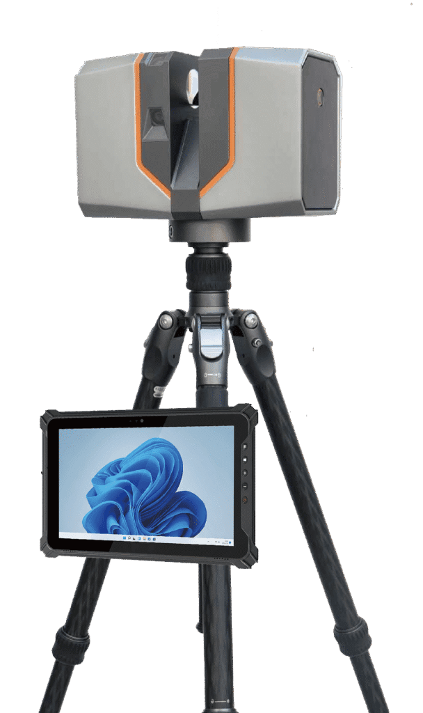
Scanner LiDAR SLAM portable TSR20 : Mobilité et excellence cartographique en temps réel
Conçu pour l'acquisition dynamique de données en mouvement, le TSR20 intègre des algorithmes SLAM avancés avec le capteur LiDAR Livox Mid-360 pour générer des nuages de points 3D denses et précis en temps réel, avec ou sans couverture GNSS.
Principaux avantages
Performance SLAM multimodePrenant en charge les modes SLAM, RTK-SLAM et PPK-SLAM, le système fusionne le LiDAR, l'IMU haute fréquence et le GNSS multi-constellations pour offrir une précision relative ≤3cm et une précision absolue ≤5cm, satisfaisant pleinement les exigences professionnelles en matière de BIM, de jumeaux numériques et de levés d'ingénierie.
Adaptabilité environnementale illimitéeAvec un balayage non répétitif à 360°, une plage de mesure de 40 m et une forte pénétration ponctuelle, le TSR20 fonctionne de manière fiable dans les espaces souterrains, les pièces intérieures, les cages d'escalier, les parkings, les couloirs de lignes électriques et les forêts à faible couvert.
Ultra-léger et ergonomiqueAvec un poids de seulement 1,0 kg et un format compact, le scanner permet à un seul utilisateur de l'utiliser confortablement tout au long de la journée. Sa conception robuste et sa faible consommation d'énergie garantissent des performances stables dans des conditions de terrain difficiles.
Réalité 3D en couleurs réellesDeux caméras ultra-larges de 20 Mpx avec des champs de vision de 200° capturent des données d'image synchronisées, produisant des modèles 3D texturés et photoréalistes avec des détails géométriques et visuels précis.
Flux de travail tout-en-unLe stockage interne de 64 Go et la carte SD extensible de 128 Go, le transfert de données sans fil par WiFi et le logiciel de post-traitement dédié permettent l'acquisition, la visualisation, la classification, le filtrage et la modélisation en un seul processus unifié.
Applications idéales
Cartographie des espaces souterrains, reconstruction 3D à l'intérieur, arpentage des bâtiments, inspection des lignes électriques, cartographie forestière, cartographie des interventions d'urgence et projets d'arpentage mobile sur de grandes superficies.
Scanner laser terrestre TSL150 : Numérisation statique de précision millimétrique
Conçu pour des mesures statiques de haute précision, le TSL150 combine la télémétrie laser à longue portée, l'imagerie HDR professionnelle et le traitement intelligent embarqué pour fournir des résultats de qualité pour les tâches d'ingénierie et de documentation les plus exigeantes.
Principaux avantages
Précision au niveau du millimètreAvec une portée maximale de 150 m, le système atteint une précision de 2 mm à 50 m et de 3 mm à 100 m, ce qui le rend idéal pour la surveillance des structures, la numérisation du patrimoine, la rétro-ingénierie BIM précise et la métrologie industrielle.
Capture de données à grande vitesseUne fréquence de répétition des impulsions de 1,2 MHz et une vitesse de balayage de 100 lignes/seconde réduisent considérablement le temps passé sur le terrain tout en produisant des nuages de points denses et de haute qualité.
Traitement intelligent sur siteLe logiciel intégré prend en charge l'enregistrement en temps réel des nuages de points, l'ajustement automatique des stations multiples et les mesures visuelles, minimisant ainsi le post-traitement au bureau et garantissant l'intégrité des données avant de quitter le site.
Déploiement compact et flexible Pesant seulement 3,3 kg et présentant un faible encombrement, le TSL150 peut être monté à la verticale ou à l'envers pour une utilisation dans des espaces confinés, des positions surélevées et des zones d'accès difficiles. Son indice de protection IP54 garantit sa durabilité dans les environnements difficiles.
Fusion multi-capteursUne caméra panoramique HDR de 100MP, un IMU MEMS et une prise en charge multi-GNSS fournissent des nuages de points géoréférencés avec précision et riches en couleurs, prêts pour la cartographie et la modélisation professionnelles.
Solutions LiDAR alimentées par SLAM : Scanner laser terrestre Toknav TSL150
Applications idéales
Préservation du patrimoine culturel, surveillance de la déformation des bâtiments, modélisation BIM de haute précision, étude des pipelines, calcul des travaux de terrassement, étude des glissements de terrain et mesure des installations industrielles.
La combinaison ultime : TSR20 + TSL150
Pour les projets de capture de la réalité 3D à l'échelle mondiale, le scanner SLAM portable TSR20 et le scanner terrestre TSL150 se complètent parfaitement :
Le TSR20 couvre rapidement les zones étendues, complexes ou difficiles d'accès grâce à une numérisation mobile efficace.
Le TSL150 fournit des détails au millimètre près pour les structures critiques, les composants clés et la documentation de haute précision.
Combinés, ils permettent une modélisation 3D de haute précision avec une couverture complète, tout en réduisant considérablement le temps, la main-d'œuvre et les coûts.
Ce puissant couplage soutient la construction numérique, les infrastructures intelligentes, la transformation numérique industrielle et les projets de conservation du patrimoine dans le monde entier.
Solutions LiDAR alimentées par SLAM : Flux de travail combiné TSR20 et TSL150
Pourquoi choisir Toknav ?
Des algorithmes professionnels de SLAM et de fusion de capteurs garantissent des performances stables et de haute précision dans divers environnements.
La conception globale permet une compatibilité multi-GNSS et fonctionne de manière fiable dans des conditions climatiques et de terrain différentes.
Le flux de travail de bout en bout intègre l'acquisition, le traitement et la modélisation afin de réduire la complexité et d'améliorer l'efficacité.
Le matériel robuste et portable est conçu pour une utilisation professionnelle quotidienne dans le cadre de projets internationaux sur le terrain.
L'assistance clientèle mondiale garantit un déploiement et une formation sans heurts, ainsi qu'une fiabilité à long terme.
Découvrez les solutions de capture de réalité 3D de Toknav
Découvrez comment le TSR20 et le TSL150 peuvent améliorer la précision, la vitesse et l'efficacité de vos projets : Toknav TSR20, Toknav TSL150, SLAM LiDAR portable, scanner laser terrestre, capture de la réalité en 3D, système de numérisation SLAM.
Toknav fournit des solutions LiDAR professionnelles, fiables et prêtes à l'emploi pour transformer les espaces physiques en actifs numériques précis et utilisables.