
Case Studies
TOKNAV GNSS Case Studies: CORS, Monitoring, USV and Robots
Real-world and publicly usable TOKNAV application stories for CORS/VRS planning, deformation monitoring, sports field marking robots, hydrographic survey, agriculture and machine control. Each case summarizes the country or buyer context, equipment, workflow, buyer result and next step for similar projects.
Customer names are kept anonymous unless already approved for public use. Where a public customer name or exact site is not approved, the case is presented as an application case with buyer context, equipment path and verifiable planning outcome instead of invented names or unsupported claims.
Priority Application Cases
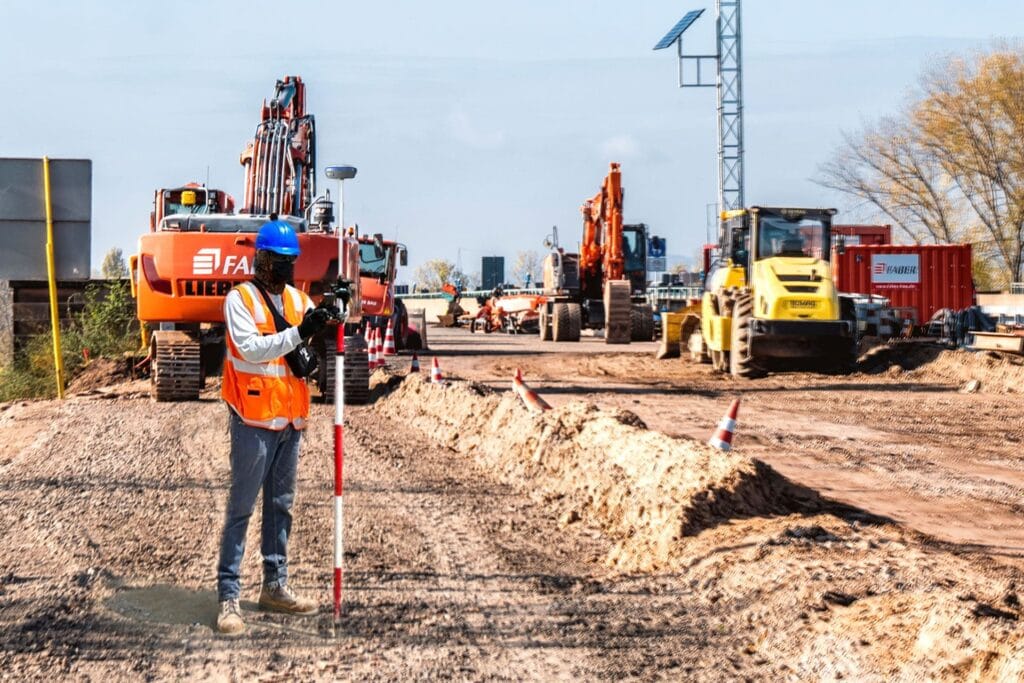
France: RTK Base-Rover Road Resurvey
Country: France
Industry: Road surveying and engineering resurvey
Equipment: TOKNAV GNSS base-rover kit, RTK rover workflow, UHF plus 4G fallback communication
Herausforderung: A rural road resurvey team faced a tight deadline, mixed open farmland and tree-lined sections, and unstable cellular coverage.
Workflow: The team set a fixed base station on a certified control point with open sky view, then used UHF where cellular coverage was weak and 4G fallback across open sections.
Ergebnis: The team achieved consistent centimeter-level accuracy, avoided rework and finished the 12 km road project two days ahead of schedule.
Philippines: Tboat USV Hydrographic Survey and Monitoring
Country: Philippines
Industry: Hydrographic survey, bathymetry and water quality monitoring
Equipment: Tboat10, Tboat20, RTK positioning, echo sounder and water-quality payload options
Herausforderung: Local teams needed safer and more repeatable water survey workflows for coastal shallow water, rivers and remote island conditions.
Workflow: Tboat USVs supported automatic route planning, real-time video/data feedback, RTK positioning and flexible payload integration for survey and monitoring tasks.
Ergebnis: Philippine users reported stable field performance, accurate depth data, easier transport and lower manual risk compared with traditional boat-based workflows.
CORS/VRS Infrastructure: Reference Station Planning Case
Country: Project country to be confirmed by buyer
Industry: CORS, VRS, reference station and network RTK infrastructure
Equipment: NET660, NET660i, tBase, TCA920 and station accessories
Herausforderung: Buyers often request a CORS/VRS quote before confirming station count, antenna environment, communication, power and expected rover users.
Workflow: TOKNAV first collects country, coverage area, station quantity, receiver preference, antenna environment and data communication plan.
Ergebnis: A clearer station plan helps the buyer compare receiver, antenna, server/workflow and maintenance requirements before procurement.
Deformation Monitoring: Dam, Slope and Infrastructure Planning Case
Country: Buyer-defined infrastructure site
Industry: GNSS deformation monitoring for dams, slopes, mines, bridges and buildings
Equipment: NET660i, TCA920, monitoring devices, power and communication components
Herausforderung: Monitoring buyers need to define point quantity, reference points, accuracy target, data interval, power, communication and alert workflow before hardware selection.
Workflow: TOKNAV uses a project intake checklist to connect site photos, point layout and reporting requirements with receiver, antenna and communication planning.
Ergebnis: The buyer can move from a broad monitoring request to a clearer bill of materials and integration discussion.
Sports Field Marking Robot: Soccer and Multi-Sport Venue Case
Country: Venue or contractor market to be confirmed by buyer
Industry: Sports facility construction, campus maintenance and field line marking
Equipment: TR10Pro sports field marking robot with GNSS/RTK positioning and digital field templates
Herausforderung: Venues and contractors need repeatable soccer, football, lacrosse, baseball and custom training layouts with less manual measuring and rework.
Workflow: Operators choose a field template, confirm site conditions, prepare paint and RTK correction, then run a repeatable robotic marking path.
Ergebnis: Facilities can standardize line marking quality and make multi-field preparation more predictable.
Agriculture and Machine Control: Field Leveling and Guidance Case
Country: Farm, contractor or dealer market to be confirmed by buyer
Industry: Precision agriculture, land leveling, dozer guidance and excavator guidance
Equipment: TAG66, TAG88, TMC10, TMC20 and compatible GNSS receiver workflows
Herausforderung: Dealers and project teams need to match steering, land leveling or machine control hardware with vehicle type, worksite condition and accuracy target.
Workflow: TOKNAV collects crop or operation type, machine model, field or construction environment, correction method and expected deployment quantity.
Ergebnis: Buyers receive a clearer product path before quotation instead of comparing unrelated agriculture and construction positioning products.
Additional Public Proof Story
China, Hangzhou: Heritage Building Digitalization and Crack Discovery
Country: China
Industry: Heritage conservation, building digitalization and 3D mapping
Equipment: TOKNAV TSR20 handheld LiDAR scanner with SLAM / RTK-SLAM workflows
Herausforderung: A Qing Dynasty residence in Hangzhou required detailed digital documentation to support restoration planning.
Workflow: TSR20 point clouds were combined with historical archive information to reconstruct building evolution and inspect structural details.
Ergebnis: The scan revealed hidden structural cracks and provided a data foundation for restoration planning.
Need to Turn a Project Into a Case Study?
Best fit: Projects with approved photos, site context, product list and measurable result.
Useful evidence: Field photos, screenshots, point layout, route map, survey output, monitoring graph or acceptance notes.
Publishing rule: TOKNAV can keep customer names anonymous unless public approval is available.
Case Study Comparison
| Case | Country | Industrie | Equipment | Buyer result |
|---|---|---|---|---|
| RTK road resurvey | France | Road surveying | GNSS base-rover kit, RTK rover, UHF/4G workflow | Centimeter-level accuracy and 12 km project completed two days ahead of schedule. |
| Tboat hydrographic survey | Philippines | Hydrographic survey and water monitoring | Tboat10, Tboat20, RTK positioning and payload integration | Stable field performance, safer water survey workflow and easier daily deployment. |
| Heritage building digitalization | China | Heritage conservation and 3D mapping | TSR20 handheld LiDAR scanner | Hidden cracks identified and restoration planning supported by point cloud data. |
| CORS/VRS station planning | Buyer-defined | Reference station infrastructure | NET660, NET660i, tBase, TCA920 | Clearer receiver, antenna, communication and maintenance plan before quotation. |
| Deformation monitoring planning | Buyer-defined | Dams, slopes, mines, bridges and buildings | NET660i, TCA920, monitoring devices | Monitoring points, accuracy, data interval and reporting workflow clarified before configuration. |
| Sports field marking robot | Buyer-defined | Sports venue construction and maintenance | TR10Pro sports field marking robot | More repeatable soccer and multi-sport field marking workflow for venue teams. |
| Agriculture and machine control | Buyer-defined | Precision agriculture and construction guidance | TAG66, TAG88, TMC10, TMC20 | Clearer product path for steering, land leveling, dozer or excavator guidance projects. |
Use These Guides to Plan a Similar Project
- Compare GNSS receivers
- Plan VRS infrastructure
- CORS Station Setup Checklist
- GNSS Deformation Monitoring Guide
- GNSS Antenna Selection Guide
- Sportplatz-Markierungsroboter
- Machine Control Guidance
- Download datasheets and brochures
What TOKNAV Needs to Build Your Case or Proposal
Project Details
- Country, industry and application.
- Products or equipment being considered.
- Required accuracy, correction method and operating environment.
- Photos, drawings, route map, station layout or monitoring point plan.
Approved Proof
- Public customer name or permission to keep it anonymous.
- Approved country/region disclosure.
- Approved photos, field screenshots, data examples or test notes.
- Result claims that can be verified and used publicly.
Request a Similar Solution
Share your country, project type, equipment interest, field environment and desired result. TOKNAV can recommend a receiver, antenna, software, USV, LiDAR or complete solution package.