
TOKNAV Hydrographic Survey Equipment: Professional Solutions for Precise Underwater Mapping
2026-03-16
Introduction: Core Value of Hydrographic Survey & Equipment
Without precise hydrographic data, maritime operations face severe risks like vessel grounding, structural damage and inefficiency, making reliable hydrographic survey equipment indispensable for modern waterway and marine projects.
Toknav breaks down key hydrographic survey gear, details TOKNAV’s Tboat10/Tboat20 USV-integrated solutions, outlines European compliance rules and walks through a full project workflow, all centered on professional-grade, field-ready equipment.
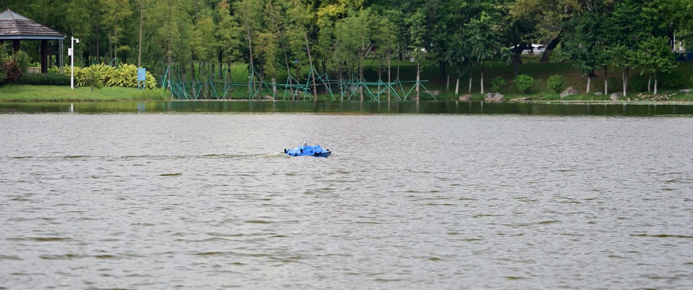
TOKNAV hydrographic survey equipment in field operation for precise water mapping
Core Hydrographic Survey Equipment & TOKNAV Applications
Marine USV for Survey: TOKNAV Tboat10 & Tboat20 Series
Marine USV for survey (Unmanned Surface Vehicle) is a game-changing asset in modern hydrographic surveying, eliminating the need for manned vessels and enhancing operational safety, efficiency, and flexibility. TOKNAV’s flagship Tboat10 and Tboat20 series stand out as premium carriers for hydrographic survey equipment, engineered to navigate shallow waters, narrow channels, hazardous coastal zones, and remote water bodies that are inaccessible or high-risk for crewed boats, with rugged builds and intelligent systems tailored for professional survey work.
The Tboat10 series features a double-hull M-type monohull crafted from high-molecular-weight carbon fiber, with full-perimeter anti-collision strips and reinforced bow/keel protection, weighing just 7kg (hull) and 30kg total, boasting a 35kg maximum payload to accommodate core hydrographic survey equipment like echo sounders and side-scan sonars.
It runs on dual automotive-grade 33.6V 25Ah ternary lithium batteries, supporting hot-swap replacement without shutdown, delivering 3 hours of operation at 2m/s and 7 hours at 1.5m/s per battery set, with a maximum speed of 7m/s and safe passage through 4m/s cross-currents.
For larger-scale projects, the Tboat20 series offers a full-curved V-shaped hull made of polyester carbon fiber composite and Kevlar fabric, IP67 waterproof rated, with 12kg hull weight, 40kg total weight, and a 50kg maximum payload, powered by 1100W brushless dual motors, reaching 6m/s max speed and matching the Tboat10’s impressive 7-hour low-speed endurance.
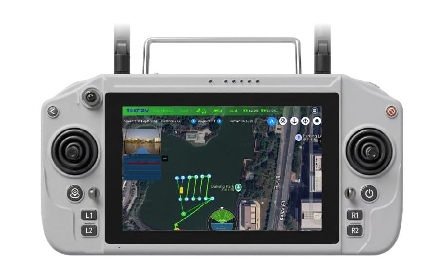
Both models feature full-system multi-frequency satellite tracking (BDS, GPS, GLONASS, Galileo, SBAS, QZSS), radar-based obstacle avoidance, automatic shallow-water tracking reverse, and intuitive tSail control software supporting multi-mode route planning and breakpoint resume.
Beyond accessibility, these USVs cut operational costs by eliminating fuel and labor overheads, supporting uninterrupted long-duration missions to collect consistent, high-quality data for port management, river mapping, and offshore surveys—solidifying their role as irreplaceable core hydrographic survey equipment.
Echo Sounder: High-Precision Depth Measurement Gear
The echo sounder is the core depth-measuring device in hydrographic survey equipment, working on acoustic principles to transmit sound waves underwater and calculate water depth by measuring the time it takes for waves to reflect off the seabed. Paired with TOKNAV’s USV platforms, the integrated echo sounder delivers industry-leading accuracy, with a 200kHz operating frequency, 8° beam angle for Tboat10 and 5°±1° for Tboat20, and a depth detection range of 0.15-200m (optional extended range available).
This precision hydrographic survey equipment boasts an 8mm depth resolution, with stability rate of ±2cm (CEP 0.95 @ 10m) and accuracy of ±1cm + 0.1% D (D=water depth value), ensuring flawless measurements even in turbid waters. It supports sound velocity adjustment from 0-1700 m/s, operates on 9V-28V power, and consumes just 5-10W, perfectly compatible with the USVs’ battery systems.
Advanced noise filtering technology eliminates interference from water currents and suspended sediments, and every depth reading is synced with precise GNSS coordinates, making it a non-negotiable component of any professional hydrographic survey equipment kit.
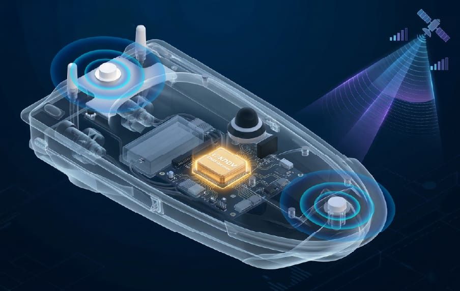
GNSS RTK Receiver: Centimeter-Level Positioning Core
GNSS RTK receiver (Global Navigation Satellite System Real-Time Kinematic) is the cornerstone of high-precision positioning for hydrographic survey equipment, providing centimeter-level location accuracy critical for reliable underwater mapping. TOKNAV’s integrated GNSS RTK system, built into Tboat10 and Tboat20, outperforms standard GNSS receivers with real-time base station corrections, erasing satellite signal errors and atmospheric interference.
TOKNAV GNSS RTK receiver – centimeter-level positioning core for hydrographic survey equipment
Build a Professional Hydrographic Survey Kit
Build a tailored kit by matching gear to project scale and environment: choose Tboat10 for small inland surveys, Tboat20 for large offshore projects. Integrate factory-calibrated echo sounders and RTK receivers for seamless compatibility, add 4G/2.4G communication modules, long-endurance remote batteries and IP67 enclosures for harsh conditions.
TOKNAV’s plug-and-play design simplifies deployment, and dedicated software converts raw data into actionable charts and 3D models, eliminating compatibility gaps and boosting efficiency.
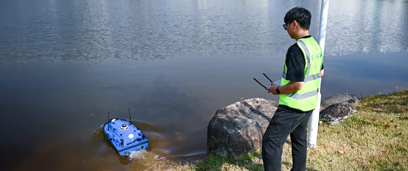
Complete TOKNAV hydrographic survey equipment kit assembly guide
TOKNAV Integrated Hydrographic Survey Solutions
TOKNAV integrated hydrographic survey equipment solution for practical water mapping projects
TOKNAV provides fully integrated, plug-and-play hydrographic survey solutions, merging USVs, echo sounders and RTK receivers into a unified workflow. Pre-calibrated and pre-configured, the systems cut deployment time and training costs, with intelligent features like one-touch control and hot-swap batteries for nonstop operation.
Compliant with global standards and backed by professional support, TOKNAV equipment helps teams deliver high-quality, compliant data efficiently, making it a trusted choice for survey professionals worldwide.
European Compliance & Standards
European hydrographic projects adhere to strict IHO S-44 bathymetric standards, EU maritime safety rules and environmental directives, requiring centimeter-level positioning, high-resolution measurement and low-impact design.
TOKNAV hydrographic survey equipment meets and exceeds these standards: RTK receivers hold certified precision, echo sounders pass rigorous calibration, and Tboat USVs feature IP67 waterproofing, low noise and eco-friendly materials. Full compliance ensures smooth project approval and avoids costly reworks for European surveys.
Complete Hydrographic Survey Workflow
1. Pre-Survey Planning: Define project scope, survey area, and accuracy requirements; select TOKNAV hydrographic survey equipment(Tboat10 for small projects, Tboat20 for large-scale); calibrate GNSS RTK and echo sounder; program USV routes via tSail software.
2. Field Deployment & Data Collection: Launch the TOKNAV marine USV, activate autonomous mode; collect real-time depth data via echo sounder and RTK positioning; monitor operations via 360° night vision camera and remote control (1200-nit sunlight-readable display).
3. Data Processing & Validation: Transfer raw data to TOKNAV software; filter noise, correct tide levels, and integrate datasets; validate against IHO S-44 and EU standards to ensurehydrographic survey equipmentdata compliance.
4. Reporting & Deliverables: Generate high-precision hydrographic charts, 3D seabed models, and depth contour maps; compile compliance reports and project documentation for client submission.
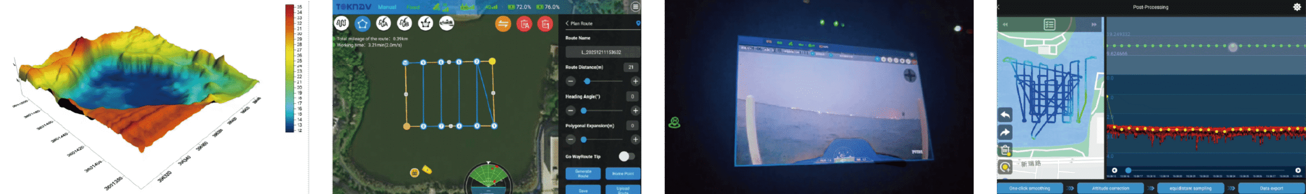
TOKNAV hydrographic survey project workflow with professional hydrographic survey equipment
Conclusion
With reliable specs, durable builds and EU-compliant design, this gear enhances safety, cuts costs and ensures consistent data collection for all aquatic projects. Upgrade your survey toolkit with TOKNAV’s field-proven solutions—visit our solutions page to explore Tboat series, request a quote or consult our team for a customized kit today.