
تقود حلول TOKNAV RTK و SLAM نجاح المسح في الأرجنتين - الأداء الميداني لـ tBase و T45 و TSR20
2026-04-20
Argentina is a country of incredible geographic diversity: from the fertile plains of the Pampas to the rugged slopes of the Andes, from dense forests in the north to urban centers like Buenos Aires, and from large-scale agriculture to heavy construction and infrastructure projects. For surveyors, engineers, construction managers, and agricultural teams across Argentina, reliable high-precision positioning equipment is not just useful—it is essential. Teams need tools that deliver centimeter-level accuracy, work reliably under tree cover or in city canyons, survive harsh weather, and fit real-world workflows. Today, we are proud to share real feedback, photos, and video results from our authorized TOKNAV dealer in Argentina, who has deployed TOKNAV’s flagship products: the tBase GNSS base station, T45 multi-functional RTK receiver, and TSR20 handheld SLAM LiDAR scanner. These tools are proving themselves daily across Argentine projects, and they are quickly becoming the go-to choice for professionals who want the best RTK & SLAM 2026 has to offer, without paying premium international prices.
لماذا تُعد TOKNAV الخيار الأفضل للمساحين وفرق البناء الأرجنتينية
Discover the Best RTK & SLAM 2026 for Your Projects
تُعد TOKNAV شركة رائدة عالميًا في حلول رسم الخرائط عالية الدقة لنظام الملاحة العالمي للأنظمة العالمية لسواتل الملاحة (GNSS) ونظام تحديد المواقع المتكامل (RTK) ونظام رسم الخرائط بنظام تحديد المواقع العالمي (SLAM)، المصممة خصيصًا للمسح الاحترافي للأراضي والبناء والزراعة الدقيقة وفحص البنية التحتية وإنشاء التوائم الرقمية. على عكس أدوات نظام تحديد المواقع العالمي لتحديد المواقع من فئة المستهلكين، تبني TOKNAV أجهزة من الدرجة الصناعية مع تتبع الأقمار الصناعية ذات الكوكبة الكاملة، وتكامل وحدة القياس المتكاملة المتقدمة ومعالجة البيانات متعددة الأوضاع. بالنسبة للمستخدمين الأرجنتينيين، هذا يعني الاستقرار في الأماكن التي تفشل فيها أجهزة الاستقبال الأخرى: تحت المظلات الثقيلة، وعلى المنحدرات الحادة، وفي مناطق البناء المتربة، وفي ظل الظروف الجوية المتغيرة. ويؤدي الجمع بين جهاز استقبال T45 RTK ومحطة tBase الأساسية والماسح الضوئي TSR20 SLAM إلى إنشاء سير عمل كامل لتحديد المواقع من البداية إلى النهاية يغطي كل مهمة - بدءًا من مسوحات التحكم الثابتة ورسم الخرائط الطبوغرافية إلى التقاط الواقع ثلاثي الأبعاد ومراقبة البناء. أبلغ المحترفون الأرجنتينيون عن عدد أقل من حالات التسرب، وأوقات إصلاح أسرع، وعمر بطارية أطول، وتشغيل أسهل من العلامات التجارية المنافسة التي استخدموها في الماضي. بالنسبة لشركات المسح الصغيرة، وشركات البناء الكبيرة، والعمليات الزراعية، والمشاريع الحكومية، تقدم TOKNAV أداءً وقيمة تتماشى تمامًا مع الاحتياجات المحلية.
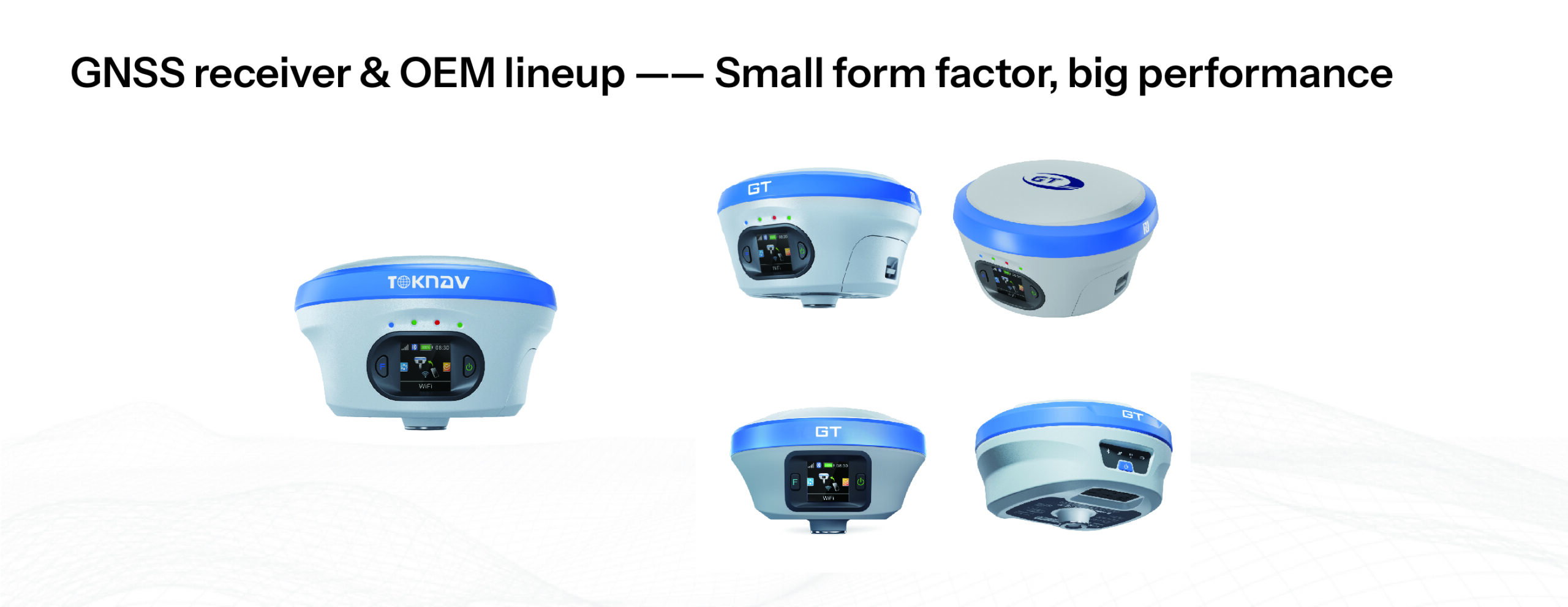
منتجات TOKNAV RTK: قاعدة T45 وقاعدة TBase ومجموعة أدوات الاستكشاف للعمل عالي الدقة
عندما تبحث الفرق في الأرجنتين عن أفضل جهاز استقبال RTK GPS 2026، فإنها تعطي الأولوية لثلاث ميزات غير قابلة للتفاوض: الدقة المثبتة وجودة البناء القوية وأداء الإشارة القوي في البيئات الصعبة. يتحقق طقم قاعدة T45 وTBase RTK وTBase الميسور التكلفة من TOKNAV T45 وTBase، وهو جهاز RTK الأساسي والمتجول من كل المربعات. صُممت T45 للاستخدام الاحترافي، وهي عبارة عن جهاز استقبال GNSS RTK محمول وقوي يعمل بنظام GNSS RTK مدعوم بمنصة Linux عالية الأداء ومزود ب 1408 قناة تتبع GNSS. يسمح هذا العدد الكبير من القنوات باكتساب الأقمار الصناعية بسرعة فائقة وتتبع مستقر حتى في الغابات الكثيفة أو الأخاديد الحضرية أو المناطق الجبلية حيث تكون الإشارات ضعيفة أو محجوبة في كثير من الأحيان. بالنسبة للمسّاحين الأرجنتينيين الذين يعملون في المناطق النائية أو التضاريس الصعبة، فإن هذا يعني عددًا أقل من الانقطاعات، وحلولاً ثابتة أسرع في نظام RTK، وساعات أكثر إنتاجية في الميدان.
أفضل جهاز استقبال RTK GPS 2026 لأفضل جهاز استقبال RTK لتحديد المواقع 2026 للتضاريس المتنوعة في الأرجنتين
يجب أن يكون أداء أفضل جهاز استقبال RTK GPS 2026 موثوقًا عبر المناظر الطبيعية المتنوعة في الأرجنتين، ويفي جهاز T45 بذلك. فهو يدعم التتبع الكامل متعدد الكوكبات: GPS، وGLONASS، وGalileo، وBiDou، وأنظمة الأقمار الصناعية العالمية الأخرى. تضمن هذه التغطية الكاملة قدرة جهاز الاستقبال على قفل الإشارات بغض النظر عن المكان الذي يأخذك إليه العمل. تم تصميم المحطة الأساسية الاحترافية لنظام الملاحة العالمي للأنظمة العالمية لسواتل الملاحة tBase لتغطية تفاضلية مستقرة وبعيدة المدى. وبفضل الراديو الداخلي عالي الطاقة، فإنه يوفر اتصالاً ثابتًا عبر مسافات طويلة - وهو مثالي للحقول الزراعية الكبيرة، وبناء الطرق، ومسوحات التعدين، ومشاريع البنية التحتية الشائعة في جميع أنحاء الأرجنتين. يشكل كل من T45 و tBase معًا قاعدة RTK كاملة ومجموعة أدوات RTK كاملة ومجموعة أدوات تجوال تدعم كلاً من اتصالات الراديو UHF وشبكة 4G باستخدام NTRIP و CORS. يضمن هذا التصميم ثنائي الوصلة المزدوجة تصحيحات RTK ثابتة حتى في المناطق الريفية ذات الإنترنت المحدود، وهي ميزة كبيرة للفرق التي تعمل بعيدًا عن المراكز الحضرية.
TOKNAV T45 & tBase RTK Base Rover Kit في مسح الأرجنتين
وحدة القياس والتتبع والتعويض عن الميل بوحدة القياس والتتبع والتعويض عن الميل بوحدة القياس والتتبع للتعويض عن الميل بوحدة القياس والتتبع للمسح الأسرع على المنحدرات
الكثير من الأراضي في الأرجنتين منحدرة - من مزارع الكروم في مندوزا إلى بناء الطرق على طول المناطق الجبلية. وتتطلب أجهزة استقبال RTK التقليدية من المساحين تسوية العمود بشكل مثالي لكل عملية قياس، مما يؤدي إلى إبطاء العمل وزيادة الإرهاق. يعمل TOKNAV T45 على التخلص من هذه المشكلة من خلال تقنية تعويض إمالة وحدة المسح الآلي للتعريف بالتوقيت الراديوي (RTK)، مما يوفر قياسات دقيقة حتى عند الميل حتى 60 درجة. ويظل خطأ التصحيح أقل من 2 سنتيمتر، مما يفي بمعايير الدقة الصارمة للمسح المساحي وتخطيط البناء وأعمال البنية التحتية. أبلغت الطواقم الميدانية الأرجنتينية عن تقليل الوقت الميداني بنسبة 30-40% في المشاريع المنحدرة لأنهم لم يعودوا بحاجة إلى التوقف وتسوية العمود بشكل متكرر. كما أن ميزة تعويض إمالة وحدة قياس الميل IMU هذه تقضي أيضًا على “النقاط المتطايرة” الشائعة مع المعدات القديمة، مما يضمن بيانات نظيفة وموثوقة يتم استيرادها بسلاسة إلى برامج التصميم بمساعدة الحاسوب ونظم المعلومات الجغرافية. بالنسبة لأي فريق يعمل على أرض غير مستوية، فإن هذه الميزة وحدها تجعل TOKNAV خيارًا أكثر ذكاءً.
جهاز استقبال RTK متين IP68 متين للبيئات القاسية
يتنوع مناخ الأرجنتين بشكل كبير، من الحرارة الشديدة في السهول الشمالية إلى الظروف الباردة والرطبة في باتاغونيا والمناطق الجبلية المرتفعة. يجب أن تقاوم معدات المسح الغبار والرطوبة والسقوط والتغيرات في درجات الحرارة. ويتميز كل من جهاز الاستقبال T45 والمحطة الأساسية tBase بهيكل جهاز استقبال RTK متين IP68 مع غلاف متين من سبائك الماغنسيوم. وهما مقاومان تمامًا للماء والغبار والصدمات وقادران على تحمل السقوط من ارتفاع 1.5 متر. يمتد نطاق درجة حرارة التشغيل من -30 درجة مئوية إلى +65 درجة مئوية، مما يجعلها مناسبة لحرارة الصيف وبرودة الشتاء على حد سواء. يشترك الماسح الضوئي TSR20 SLAM في جودة البنية المتينة هذه، حيث يعمل بشكل موثوق من -20 درجة مئوية إلى +55 درجة مئوية. بالنسبة لأطقم العمل الميدانية الأرجنتينية التي تعمل لأيام طويلة في ظروف قاسية، فإن هذا التصميم المتين يعني وقت تعطل أقل، وإصلاحات أقل، وتكلفة إجمالية أقل للملكية بمرور الوقت.
الماسح الضوئي المحمول TSR20 SLAM: رسم الخرائط ثلاثية الأبعاد في المناطق المحرومة من النظم العالمية لسواتل الملاحة في الأرجنتين
تتطلب العديد من المشاريع الأرجنتينية رسم الخرائط في المناطق التي تكون فيها إشارات نظام الملاحة العالمي لسواتل الملاحة ضعيفة أو غير متوفرة: الأجزاء الداخلية للمباني، ومرافق وقوف السيارات تحت الأرض، والأنفاق، والغابات الكثيفة، والأودية الحضرية المحاطة بالمباني العالية. هذا هو المكان الذي يصبح فيه ماسح TOKNAV TSR20 المحمول باليد SLAM LiDAR لا غنى عنه. صُمم الماسح الضوئي بالليزر SLAM دون الاعتماد على إشارات الأقمار الصناعية، حيث يلتقط TSR20 سحباً نقطية ثلاثية الأبعاد دقيقة مع أو بدون نظام الملاحة العالمي للأنظمة العالمية لسواتل الملاحة. وهو يوفر دقة نسبية في حدود 3 سم ودقة مطلقة في حدود 5 سم، مما يجعله مثاليًا للمسح المعماري والتحقق من البناء وفحص البنية التحتية والحفظ التاريخي ورسم الخرائط الداخلية.
يبلغ وزن جهاز TSR20 1.0 كجم فقط، وهو سهل الحمل للغاية ومصمم للاستخدام المحمول باليد طوال اليوم في المواقع الداخلية والخارجية. وهو يدعم ثلاثة أوضاع لرسم الخرائط: SLAM و RTK-SLAM و PPK-SLAM، مما يسمح للمستخدمين بالتبديل بمرونة بين رسم الخرائط في الوقت الفعلي وسير العمل بعد المعالجة. بالنسبة للمهندسين المعماريين والمهندسين وفرق البناء في الأرجنتين، ينشئ TSR20 نماذج ثلاثية الأبعاد مفصلة وتوائم رقمية تتكامل مباشرةً مع برامج نمذجة معلومات المباني ونظم المعلومات الجغرافية. كما يتضمن أيضاً كاميرات مزدوجة عالية الدقة لالتقاط نسيج متزامن بالألوان الحقيقية وتحويل السحب النقطية الهندسية إلى نماذج ثلاثية الأبعاد واقعية ودقيقة بصرياً. وسواء أكان رسم الخرائط الداخلية لمبنى في بوينس آيرس أو منطقة غابات في شمال الأرجنتين، فإن TSR20 يعمل بشكل موثوق حيث لا تستطيع أدوات GPS التقليدية القيام بذلك.
الماسح الضوئي TOKNAV TSR20 SLAM LiDAR لرسم الخرائط ثلاثية الأبعاد في الأرجنتين
ملاحظات ميدانية حقيقية من وكيل TOKNAV المعتمد في الأرجنتين
وقد نشر وكيلنا المعتمد المعتمد لدى TOKNAV في الأرجنتين أجهزة T45 وTBase وTSR20 في عشرات المشاريع الحقيقية: مسوحات الأراضي الزراعية في بامباس، ورسم خرائط ثلاثية الأبعاد للبناء في المناطق الحضرية، ومراقبة المنحدرات في المقاطعات الغربية، والمسوحات الطبوغرافية لتطوير البنية التحتية. وكانت ردود الفعل متسقة: تتفوق TOKNAV على العلامات التجارية المنافسة في ثبات الإشارة والمتانة وسهولة الاستخدام والقيمة الإجمالية.
1408 قناة GNSS GNSS للتثبيت السريع في الغابات والأودية الحضرية
تعد إحدى الشكاوى الرئيسية التي يواجهها المساحون الأرجنتينيون هي بطء تحديد الموقع عبر نظام RTK أو فقدانه تحت غطاء الأشجار أو في المدن المكتظة بالسكان. يحل جهاز T45 و tBase هذه المشكلة بفضل قدرة GNSS ذات 1408 قناة، التي تتعقب كل إشارة قمر صناعي متاحة عبر جميع الترددات. يوفر هذا الدعم الكامل للمجموعة من الأقمار الصناعية عمليات بدء تشغيل أسرع، وتهيئة RTK أسرع، واحتفاظًا أقوى بالإحداثيات حتى في البيئات الصعبة. في الاختبارات الميدانية التي أجريت في المناطق الحرجية، حافظ جهاز T45 على تحديد موقع RTK بمعدل أعلى بكثير من الأجهزة المنافسة ذات القنوات الأقل. بالنسبة للمساحين والمزارعين وفرق البناء، يعني هذا عملًا أسرع وبيانات أكثر موثوقية ورحلات أقل للعودة إلى الميدان لإعادة القياسات.
سير عمل كامل وسهولة استخدام يناسب الظروف الميدانية الأرجنتينية
لا توفر TOKNAV أجهزة عالية الجودة فحسب - بل توفر سير عمل كامل من الميدان إلى النهاية مصمم لسهولة الاستخدام في العالم الحقيقي. تم تصميم كل ميزة لجعل العمل أسرع وأبسط وأكثر موثوقية للمحترفين في الأرجنتين.
نظام تحديد المواقع العالمي لتحديد المواقع بالواقع المعزز لكفاءة تخطيط الإنشاءات
تعتمد فرق البناء في جميع أنحاء الأرجنتين على نظام تحديد المواقع بالواقع المعزز (AR) لتسريع عملية التخطيط وتقليل الأخطاء. ويشتمل جهاز T45 على كاميرا مدمجة ذات زاوية واسعة للغاية لتحديد المواقع بالواقع المعزز في الوقت الفعلي، مما يتيح للمشغلين رؤية نقاط التصميم مركبة على العالم الحقيقي عبر شاشة وحدة التحكم. يقلل هذا التوجيه البصري من وقت التدريب، ويحد من أخطاء التخطيط، ويسرع عملية تخطيط البناء بشكل كبير. كما يشتمل الجهاز على وحدة قياس مسافات بالليزر عالية الدقة لقياس المسافات والارتفاعات بدقة دون الحاجة إلى أدوات إضافية. بالنسبة لمشاريع البناء من جميع الأحجام، يعني هذا أن جهازًا واحدًا يقوم بعمل العديد من الأجهزة، مما يبسط عملية إدارة المخزون ويعزز كفاءة طاقم العمل.
تهيئة واجهة WebUI والشحن السريع من النوع C للراحة الميدانية
يدعم كل من T45 و tBase تكوين WebUI، مما يسمح للمستخدمين بإعداد جهاز الاستقبال ومراقبته وضبطه باستخدام أي متصفح ويب - دون الحاجة إلى برنامج خاص أو وحدة تحكم. تُعد هذه الإدارة عن بُعد مفيدة للغاية للمحطات الأساسية المنتشرة في المناطق النائية، حيث يمكن للفنيين ضبط الإعدادات دون السفر إلى الموقع. يتميز T45 أيضاً بتقنية الشحن السريع من النوع C، مع دعم بطارية طويلة العمر لأكثر من 16 ساعة من الاستخدام الميداني. تشتمل محطة tBase الأساسية على بطارية عالية السعة للنشر طوال اليوم، ويدعم تصميم TSR20 منخفض الطاقة جلسات العمل الممتدة. بالنسبة للأطقم الأرجنتينية التي تعمل لأيام طويلة في مواقع بعيدة، فإن ميزات الراحة هذه تقضي على القلق بشأن البطارية وتحافظ على المشاريع في الموعد المحدد.
نظام تحديد المواقع العالمي لتحديد المواقع TOKNAV T45 AR Stakeout GPS لمخطط البناء في الأرجنتين
PPK وRTK-SLAM لمشاريع رسم الخرائط بالطائرات بدون طيار ورسم الخرائط المتنقلة
تستخدم العديد من مشاريع المسح في الأرجنتين طائرات بدون طيار لرسم الخرائط الجوية. ويدعم نظام TOKNAV كلاً من سير عمل RTK وPPK، مما يمنح الفرق مرونة بناءً على توفر الإشارة. يوفر كل من tBase و T45 تصحيحات في الوقت الفعلي لرسم الخرائط بالطائرات بدون طيار، بينما يوفر وضع PPK دقة عالية حتى في المناطق التي لا توجد بها تغطية للشبكة. عند إقرانها مع الماسح الضوئي TSR20 SLAM، يمكن للفرق الجمع بين بيانات الطائرات بدون طيار الجوية مع عمليات المسح الأرضية ثلاثية الأبعاد بتقنية LiDAR لإنشاء توأم رقمي كامل للمواقع - من المباني الحضرية إلى البنية التحتية الريفية. يدمج وضع RTK-SLAM في TSR20 بيانات LiDAR مع تحديد المواقع عبر نظام تحديد المواقع العالمي لتحديد المواقع GNSS للحصول على نماذج ثلاثية الأبعاد سلسة ذات مرجعية جغرافية تعمل بشكل مثالي مع أدوات نمذجة معلومات المباني ونظم المعلومات الجغرافية. تعمل هذه الإمكانية على تحويل مشاريع البنية التحتية في الأرجنتين، مما يسمح للمهندسين بمراقبة التقدم المحرز وفحص الأصول وإدارة التوائم الرقمية بدقة على مستوى السنتيمتر.
مكان شراء TOKNAV في الأرجنتين وكيفية الحصول على الدعم المحلي
مع نمو وجود TOKNAV في جميع أنحاء أمريكا اللاتينية، أصبح الدعم المحلي وقنوات البيع الموثوقة أكثر أهمية من أي وقت مضى. يوفر وكيل TOKNAV المعتمد لدينا في الأرجنتين خدمات محلية كاملة: مبيعات المعدات، والعروض التوضيحية للمنتجات، والتدريب العملي، والدعم الفني، وخدمة الضمان، والمساعدة في الإصلاح. وهذا يعني أنك لن تضطر أبدًا إلى التعامل مع الدعم الدولي المعقد بمفردك.
موزع TOKNAV المعتمد في الأرجنتين: الخدمة والتدريب المحليان
يضمن لك الشراء من وكيل معتمد الحصول على أجهزة TOKNAV أصلية، وضمان المصنع الكامل، والوصول إلى الخبرة المحلية المصممة خصيصًا للوائح المسح الأرجنتينية واحتياجات المشروع. يقدم الوكيل الذي يتخذ من الأرجنتين مقرًا له عروضًا توضيحية شخصية للمنتج وتجارب ميدانية، وتدريبًا احترافيًا لتشغيل T45 وTBase وTSR20، ودعمًا فنيًا محليًا للإعداد واستكشاف الأخطاء وإصلاحها، وخدمات إصلاح ومعايرة سريعة، ومساعدة في إعداد CORS وNTRIP لشبكة RTK. هذا الدعم المحلي لا يقدر بثمن بالنسبة للشركات التي تنتقل إلى تقنية RTK و SLAM عالية الدقة لضمان أن فريقك يحقق أقصى أداء للمعدات من اليوم الأول.
قاعدة RTK ومجموعة أدوات التحديد عن بُعد (RTK) ذات الأسعار المعقولة لأي حجم أعمال
تلتزم TOKNAV بإتاحة حلول قاعدة RTK وحلول روفر لتحديد المواقع من الدرجة الاحترافية بأسعار معقولة للشركات من جميع الأحجام - بدءًا من شركات المسح الصغيرة إلى شركات البناء والزراعة الكبيرة. وتوفر مجموعة T45 + tBase أداءً متميزًا بتكلفة أقل من العلامات التجارية العالمية المتميزة، دون التضحية بالدقة أو المتانة. كما يوفر الماسح الضوئي TSR20 المحمول باليد SLAM نقطة دخول جذابة لرسم الخرائط ثلاثية الأبعاد، مما يجعل تقنية التوأم الرقمي في متناول الشركات الأرجنتينية التي لم تكن تستطيع في السابق تحمل تكلفة أدوات LiDAR المتطورة. تجعل خيارات الشراء المرنة والتخفيضات بالجملة من TOKNAV خياراً ذكياً للفرق التي تهتم بالميزانية وترفض التنازل عن الجودة.
ترقية سير عملك مع TOKNAV في الأرجنتين
تنمو قطاعات المسح والبناء والزراعة والبنية التحتية في الأرجنتين بشكل سريع، وتحتاج إلى أدوات تحديد المواقع التي تتناسب مع طموحها. تؤكد التعليقات الواردة من وكيلنا المعتمد: يوفر جهاز استقبال TOKNAV T45 GNSS RTK ومحطة tBase الأساسية وماسح ضوئي TSR20 المحمول باليد SLAM LiDAR الدقة والمتانة والتنوع اللازمين للتفوق في المناظر الطبيعية الفريدة في الأرجنتين. بدءًا من مسوحات RTK على مستوى السنتيمتر في بامباس إلى رسم خرائط SLAM ثلاثية الأبعاد في المراكز الحضرية، ومن مسوحات مزارع الكروم على جانب المنحدر إلى مراقبة البنية التحتية واسعة النطاق، يوفر TOKNAV حلاً كاملاً ومناسبًا للمستقبل. وبفضل نظام GNSS ذي 1408 قنوات، وتعويض إمالة وحدة قياس الميل IMU، ومراقبة الواقع المعزز، ومتانة IP68، وأوضاع RTK/PPK/SLAM المرنة، فإن أدوات TOKNAV تحل التحديات المحلية الحقيقية مع تعزيز الكفاءة والدقة والربحية.
إذا كنت على استعداد لترقية سير عمل المسح أو رسم الخرائط أو البناء باستخدام أفضل جهاز استقبال RTK GPS 2026 وتقنية المسح الضوئي المبتكرة SLAM، فقد حان الوقت المثالي للانضمام إلى العدد المتزايد من المهنيين الأرجنتينيين الذين يختارون TOKNAV.
هل أنت مستعد لتجربة دقة وأداء TOKNAV في مشاريعك في الأرجنتين؟ املأ النموذج الموجود على موقعنا الرسمي الآن لطلب عرض توضيحي مجاني للمنتج، أو أسعار مفصلة، أو معلومات الاتصال بالموزع المحلي، أو عرض أسعار لحلول مخصصة. سيستجيب فريقنا في الأرجنتين بسرعة لمساعدتك في اختيار الإعداد المثالي لـ T45 أو tBase أو TSR20 — مع توفير تدريب كامل ودعم محلي. قم بتحويل سير العمل الميداني لديك اليوم باستخدام تقنية RTK و SLAM الاحترافية من TOKNAV!