
CE ve FCC Sertifikalı: TOKNAV T40 Serisi Küresel Standartlarda Hassasiyet ve Güvenilirlik Sunuyor
2025-11-06 TOKNAV T40 Series CE FCC Certified | High-Precision GNSS Receivers
In the fast-evolving global geospatial industry, precision, reliability, and compliance with international standards have become the cornerstones of trust between technology providers and professionals worldwide. As surveyors, engineers, and geospatial experts tackle increasingly complex projects—from urban infrastructure development to environmental monitoring and land management—they rely on tools that not only deliver exceptional performance but also meet the strictest regulatory requirements across different regions. Recognizing this critical need, TOKNAV, a leading innovator in GNSS (Global Navigation Satellite System) technology, is proud to announce that its latest-generation products — the T40 and T40Pro GNSS receivers — have officially obtained both CE and FCC certifications. This dual recognition is more than just a regulatory milestone; it highlights TOKNAV’s continued dedication to advancing innovation, ensuring safety, and maintaining uncompromising quality in every product it delivers to the global geospatial market. For professionals across Europe, North America, and beyond, this certification is a testament to the brand’s commitment to excellence, offering peace of mind that their tools adhere to the highest international standards.
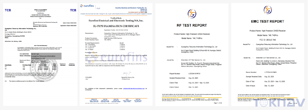
The significance of CE and FCC certifications cannot be overstated in the global technology landscape, especially for precision equipment like GNSS receivers. These certifications are not merely formalities; they are rigorous validations of a product’s ability to operate safely, reliably, and compatibly in diverse environments and markets. The CE mark, a mandatory requirement for products sold within the European Union (EU) and the European Economic Area (EEA), signifies compliance with the EU’s Radio Equipment Directive (RED), which sets strict standards for safety, electromagnetic compatibility (EMC), and environmental performance. For GNSS receivers like the T40 series, this means passing comprehensive tests to ensure they do not emit harmful electromagnetic interference (EMI) that could disrupt other electronic devices, while also being resilient to external interference that might compromise their precision. Specifically, the T40 series complies with EN 303 413:2021, the key standard for GNSS receivers under RED, and EN 301 489-1 V2.2.3 for EMC, ensuring optimal performance in complex electromagnetic environments. On the other hand, the FCC (Federal Communications Commission) certification is required for electronic devices sold or used in the United States, verifying compliance with the agency’s rules for radio frequency (RF) emissions and signal integrity. Together, these two certifications position the T40 series as a truly global product, capable of meeting the regulatory demands of two of the world’s largest and most influential technology markets.
The CE and FCC certifications validate the T40 series’ compliance with the European Union and U.S. Federal Communications Commission standards for safety, electromagnetic compatibility, and environmental performance. These approvals affirm that TOKNAV products meet the highest international requirements, ensuring reliability and trust for our global partners and customers. For TOKNAV’s clients—whether they are engineering firms operating in multiple countries, government agencies managing critical infrastructure, or independent surveyors serving local markets—this dual certification eliminates barriers to entry in key regions, allowing them to deploy the T40 series with confidence, knowing it will perform consistently and compliantly wherever their projects take them. Moreover, the certification process involved rigorous third-party testing, where the T40 and T40Pro were subjected to extreme conditions to simulate real-world field use, including temperature variations, humidity, and electromagnetic interference. Passing these tests underscores the series’ robustness and ability to deliver reliable performance even in the most demanding environments.
Cutting-edge Integration for Precision Surveying | toknav T40 series
In the geospatial industry, precision is non-negotiable. Whether measuring land boundaries, mapping underwater terrain, or guiding construction projects, even the smallest margin of error can lead to costly delays, rework, or safety hazards. To address this, the T40 series is engineered with cutting-edge technologies that push the boundaries of what GNSS receivers can achieve. The T40, designed for versatile, high-precision fieldwork, combines dual-laser measurement and high-definition visual positioning to deliver centimeter-grade accuracy—a level of precision that is essential for professional surveying applications. This precision is made possible through advanced RTK (Real-Time Kinematic) technology, which uses carrier phase measurement and differential correction to eliminate common GNSS errors, such as satellite clock drift and atmospheric delay, resulting in horizontal accuracy of ±(8 mm + 1 ppm) and vertical accuracy of ±(15 mm + 1 ppm) under RTK mode. Unlike traditional GNSS receivers that rely solely on satellite signals, the T40’s dual-laser system adds an extra layer of accuracy, allowing surveyors to measure hard-to-reach points with a laser range of up to 30 meters and a precision of ±5 mm, making it ideal for tasks like utility mapping or structural inspection.
Durability is another critical factor for field equipment, as surveyors often work in harsh, unpredictable environments—from remote construction sites to dense forests and coastal areas. The T40 addresses this with its rugged magnesium-aluminum alloy body, which offers exceptional durability while remaining lightweight (850g without batteries) for easy portability. This material is not only resistant to impact and corrosion but also provides effective thermal management, ensuring the device operates reliably in extreme temperatures ranging from -20°C to +60°C. Additionally, the T40 features an IP68 ingress protection rating, making it dust-tight and waterproof, capable of withstanding submersion in up to 1.5 meters of water for 30 minutes—perfect for use in rainy conditions or near water bodies. To further enhance its usability in demanding field environments, the T40 is equipped with hot-swappable dual batteries (7.2V, 3400mAh each), which provide over 20 hours of continuous operation with a controller network. The hot-swappable design allows users to replace a depleted battery with a fully charged one in seconds, without shutting down the device, ensuring uninterrupted workflow and eliminating the need to pause critical survey tasks.
The T40Pro, built for professional image-based surveying, takes precision and efficiency to the next level by integrating photogrammetry technology with IMU (Inertial Measurement Unit)-aided positioning and AR (Augmented Reality) stake-out capability. This powerful combination redefines the standards for field efficiency and precision mapping, allowing surveyors to streamline their workflows and reduce the time spent on data collection and processing. Photogrammetry, the science of extracting spatial information from images, enables the T40Pro to capture high-resolution images of the survey area and automatically generate detailed 3D models and topographic maps. The IMU-aided positioning ensures that even in areas with limited satellite signal—such as urban canyons or dense vegetation—the T40Pro maintains high accuracy by compensating for tilt and movement, eliminating “floating points” during RTK surveys. The AR stake-out feature, powered by a high-definition ultra-wide-angle camera (1920×1080 resolution, 70.3° horizontal field of view), overlays precise positioning data onto the real-world view, allowing surveyors to quickly and accurately locate stake-out points without the need for traditional markers or complex calculations.
This integration of technologies delivers tangible benefits for professionals across various industries. For example, in construction projects, the T40Pro can be used to quickly map construction sites, verify foundation layouts, and monitor progress with high precision, reducing the risk of errors and ensuring projects stay on schedule. In environmental monitoring, it can capture detailed images of landforms, vegetation, or water bodies, allowing researchers to track changes over time and make data-driven decisions. For land surveyors, the ability to extract high-precision coordinates directly from real-world images eliminates the need for time-consuming manual measurements, significantly improving field efficiency. The T40Pro also supports full-system, multi-frequency GNSS tracking, including GPS, GLONASS, BDS, Galileo, QZSS, SBAS, and IRNSS, ensuring reliable positioning even in challenging signal environments. With 32GB of internal storage, it can store large volumes of images and positioning data, while built-in 4G, Bluetooth, and Wi-Fi connectivity enable real-time data transmission to a controller or cloud platform for instant analysis.
Küresel Profesyoneller için Sertifikalı Mükemmellik
With CE and FCC certifications, the T40 Series fully meets international standards across key markets, opening up new opportunities for TOKNAV and its global partners. The certifications ensure that both the laser measurement system and photogrammetric imaging modules comply with stringent safety and performance regulations, making the series ideal for applications requiring high accuracy and operational safety. For professionals working in regulated industries—such as civil engineering, land management, and environmental protection—using certified equipment is often a requirement to secure projects and ensure compliance with local laws. The T40 series’ dual certification provides a competitive edge, as it demonstrates TOKNAV’s commitment to quality and regulatory compliance, giving clients confidence that their tools are reliable, safe, and fit for purpose.
Beyond regulatory compliance, the certifications also strengthen TOKNAV’s global presence, offering professionals reliable, compliant tools for demanding field environments. In the European market, the CE mark ensures that the T40 series can be freely sold and used across all EU and EEA member states, without the need for additional regional testing or certifications. This simplifies the procurement process for European clients, who can now source a single, certified product that meets all local requirements. In the United States, FCC certification ensures that the T40 series complies with the agency’s strict RF emission standards, preventing interference with other electronic devices and ensuring reliable performance in the country’s diverse radio frequency environment. For multinational companies operating in both regions, the T40 series eliminates the need to source different equipment for different markets, reducing costs and streamlining operations.
The T40 series’ certified excellence is particularly valuable in applications where safety and precision are critical. For example, in utility mapping, where surveyors work near power lines or underground cables, the T40’s compliance with safety standards ensures that the device does not pose a risk of electromagnetic interference, protecting both the user and the infrastructure. In coastal surveying, the series’ environmental durability—backed by CE and FCC testing—ensures it can withstand harsh saltwater conditions and strong winds, delivering reliable data even in challenging marine environments. Additionally, the certifications validate the T40 series’ ability to operate consistently across different climates and terrains, from the frozen landscapes of northern Europe to the hot, humid conditions of the southern United States.
Feedback from early users of the T40 series has highlighted the value of its certified performance. Professional surveyors have noted that the device’s centimeter-grade accuracy and reliable connectivity have significantly improved their workflow efficiency, reducing the time spent on data collection and verification. Government agencies have praised the series’ compliance with international standards, noting that it simplifies reporting and ensures data integrity for critical projects. For TOKNAV, this positive feedback reinforces the brand’s commitment to delivering products that meet the real-world needs of global professionals, while the CE and FCC certifications serve as an independent validation of the series’ quality and performance.
TOKNAV'ın Misyonunda İleriye Doğru Bir Adım
Building upon the success of our previously certified T30 series, the T40 and T40Pro continue TOKNAV’s mission to empower professionals worldwide with innovative, field-proven, and regulation-compliant technologies. The T30 series, which secured NGS (National Geodetic Survey) certification in 2025, established TOKNAV as a trusted provider of high-precision GNSS solutions, known for its reliability and performance in demanding field conditions. The T30 series featured integrated laser measurement, full-system GNSS support, and a rugged magnesium alloy design, laying the foundation for the T40 series’ advanced capabilities. With the T40 and T40Pro, TOKNAV has built on this legacy, incorporating cutting-edge technologies like dual-laser measurement, photogrammetry, and AR stake-out to address the evolving needs of the geospatial industry.
The development of the T40 series was driven by extensive customer feedback, which highlighted the need for more versatile, efficient, and compliant GNSS receivers. TOKNAV’s engineering team worked closely with surveyors, engineers, and environmental experts to identify pain points in current workflows—such as limited battery life, difficulty measuring hard-to-reach points, and the need for compliance across multiple markets—and incorporated solutions into the T40 and T40Pro. For example, the hot-swappable battery system was added in response to user requests for uninterrupted operation, while the dual-laser and photogrammetry technologies were included to address the need for faster, more accurate data collection. The result is a product line that not only meets international certification standards but also delivers tangible value to users, helping them complete projects more efficiently and with greater precision.
As customer feedback continues to highlight the superior stability and precision of our certified products, TOKNAV remains steadfast in its pursuit of excellence — advancing the surveying and mapping industry through trusted, high-performance solutions. The company’s commitment to innovation is evident in its ongoing investment in research and development, with a focus on integrating emerging technologies like AI (Artificial Intelligence) and machine learning into future GNSS solutions. These technologies have the potential to further enhance the T40 series’ capabilities, enabling automated data analysis, predictive maintenance, and even more precise positioning.
Looking ahead, TOKNAV aims to expand its global footprint, bringing the T40 series to more markets and empowering professionals in every corner of the world. The company’s dedication to regulatory compliance will remain a top priority, ensuring that future products continue to meet the highest international standards for safety, performance, and environmental responsibility. By combining innovation with compliance, TOKNAV is not only advancing its own mission but also contributing to the growth and development of the global geospatial industry, helping professionals tackle the world’s most complex challenges with confidence.
In a world where precision and reliability are essential, the T40 series stands out as a testament to TOKNAV’s commitment to excellence. With CE and FCC certifications, cutting-edge technology, and a user-centric design, it is poised to become the go-to choice for professionals seeking a global-standard GNSS receiver that delivers consistent performance, compliance, and value. Whether used in construction, environmental monitoring, land surveying, or any other geospatial application, the T40 series is designed to empower professionals to work smarter, faster, and more reliably—now and in the future.