Das automatisierte GNSS-Landnivelliersystem TAG88 ist ein vollautomatisches, satellitengestütztes Kontrollsystem für die präzise Landnivellierung in der Landwirtschaft. Es arbeitet rund um die Uhr, deckt einen Radius von 30 Kilometern ab und macht den häufigen Wechsel der Basisstation überflüssig. Das System unterstützt mehrere gleichzeitig arbeitende Einheiten. Mit der Echtzeitanzeige von Füll- und Abtragsmengen und der automatischen Anpassung der Position der Nivelliermaschine ermöglicht es eine schnelle und genaue Bauausführung ohne vorherige Absteckung, was die Effizienz steigert, Nacharbeiten reduziert und den wirtschaftlichen Nutzen erhöht.
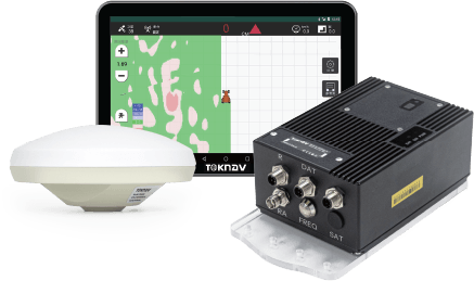
TAG88
Automatisches GNSS-Landnivellierungssystem
Das automatisierte GNSS-Landnivelliersystem TAG88 ist ein vollautomatisches, satellitengestütztes Kontrollsystem für die präzise Landnivellierung in der Landwirtschaft. Es arbeitet rund um die Uhr, deckt einen Radius von 30 Kilometern ab und macht den häufigen Wechsel der Basisstation überflüssig. Das System unterstützt mehrere gleichzeitig arbeitende Einheiten. Mit der Echtzeitanzeige von Füll- und Abtragsmengen und der automatischen Anpassung der Position der Nivelliermaschine ermöglicht es eine schnelle und genaue Bauausführung ohne vorherige Absteckung, was die Effizienz steigert, Nacharbeiten reduziert und den wirtschaftlichen Nutzen erhöht.
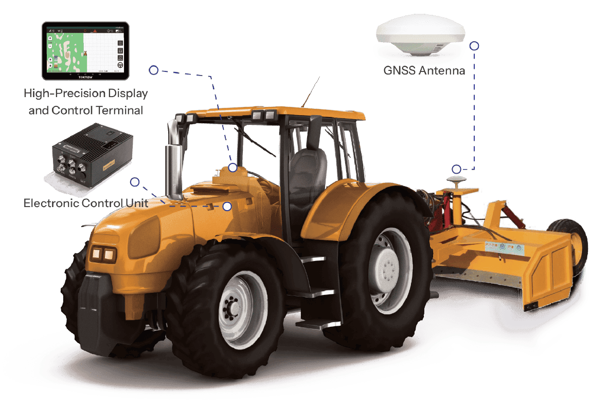
Systemarchitektur
Merkmale des Systems
Vollständige Abdeckung des Netzsignals
Das System integriert den Beidou-Satelliten und ist vollständig kompatibel mit GPS-, BDS-, GALILEO- und GLONASS-Signalen.
Multitasking
Das System umfasst eine Traktornavigation und ist mit Teleskopen, Aufreißern, Planierschildern, Scrapern und Gradern kompatibel.
Intelligenter Anzeigebildschirm
10,1-Zoll-High-Definition-Display mit sofortiger Multi-Touch-Reaktion.
24-Stunden-Dauerbetrieb
Das System ist für den 24-Stunden-Dauerbetrieb ausgelegt und kann auch bei ungünstigen Wetterbedingungen eingesetzt werden.
Kartenvisualisierung in Echtzeit
Die Benutzer können den Prozess über die Software überwachen und den Arbeitsablauf leicht nachvollziehen.
Automatische Erkennung und Anpassung
Das System erkennt automatisch Geländeschwankungen und passt den Bezugspunkt des Plans an.
Vollständige Abdeckung des Netzsignals
Das System integriert den Beidou-Satelliten und ist vollständig kompatibel mit GPS-, BDS-, GALILEO- und GLONASS-Signalen.
24-Stunden-Dauerbetrieb
Das System ist für den 24-Stunden-Dauerbetrieb ausgelegt und kann auch bei ungünstigen Wetterbedingungen eingesetzt werden.
Multitasking
Das System umfasst eine Traktornavigation und ist mit Teleskopen, Aufreißern, Planierschildern, Scrapern und Gradern kompatibel.
Kartenvisualisierung in Echtzeit
Die Benutzer können den Prozess über die Software überwachen und den Arbeitsablauf leicht nachvollziehen.
Intelligenter Anzeigebildschirm
10,1-Zoll-High-Definition-Display mit sofortiger Multi-Touch-Reaktion.
Automatische Erkennung und Anpassung
Das System erkennt automatisch Geländeschwankungen und passt den Bezugspunkt des Plans an.
Mit einer bewährten Erfolgsbilanz in der Vermessungsbranche suchen wir jetzt nach leidenschaftlichen Vertriebsmitarbeitern, die an unserer globalen Erfolgsgeschichte teilhaben möchten.